รูปภาพหรือไฟล์เสียงนี้ ต้นฉบับอยู่ที่ คอมมอนส์ รายละเอียดด้านล่าง เป็นข้อความที่แสดงผลจาก ไฟล์ต้นฉบับในคอมมอนส์ คอมมอนส์เป็นเว็บไซต์ในโครงการสำหรับเก็บรวบรวมสื่อเสรี ที่ คุณสามารถช่วยได้
ความย่อ Warning The original file is very high-resolution. It might not load properly or could cause your browser to freeze when opened at full size. To avoid these issues, use the ZoomViewer. Open in ZoomViewer
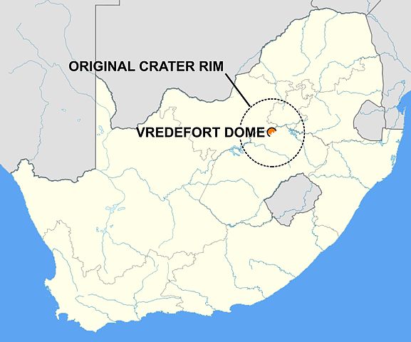
คำอธิบายMap of Vredefort dome.jpg English:
วันที่ 13 เมษายน พ.ศ. 2557, 15:11:05 แหล่งที่มา งานของตัว ผู้สร้างสรรค์ Oggmus
ตำแหน่งที่ตั้งกล้อง 27° 00′ 00.92″ ใต้, 27° 30′ 05.55″ ตะวันออก ภาพนี้และภาพอื่น ๆ ณ สถานที่เดียวกันที่ OpenStreetMap -27.000256; 27.501541
การอนุญาตใช้สิทธิ ข้าพเจ้า ในฐานะผู้ถือลิขสิทธิ์ของภาพหรือสื่อนี้ อนุญาตให้ใช้ภาพหรือสื่อนี้ภายใต้เงื่อนไขต่อไปนี้
ไฟล์นี้อยู่ภายใต้สัญญาอนุญาต ครีเอทีฟคอมมอนส์ แบบแสดงที่มา-อนุญาตแบบเดียวกัน 3.0 ต้นฉบับ
คุณสามารถ: ที่จะแบ่งปัน – ที่จะทำสำเนา แจกจ่าย และส่งงานดังกล่าวต่อไปที่จะเรียบเรียงใหม่ – ที่จะดัดแปลงงานดังกล่าว ภายใต้เงื่อนไขต่อไปนี้: แสดงที่มา – คุณต้องให้เกียรติเจ้าของงานอย่างเหมาะสม โดยเพิ่มลิงก์ไปยังสัญญาอนุญาต และระบุหากมีการเปลี่ยนแปลง คุณอาจทำเช่นนี้ได้ในรูปแบบใดก็ได้ตามควร แต่ต้องไม่ใช่ในลักษณะที่แนะว่าผู้ให้อนุญาตสนับสนุนคุณหรือการใช้งานของคุณอนุญาตแบบเดียวกัน – หากคุณดัดแปลง เปลี่ยนรูป หรือต่อเติมงานนี้ คุณต้องใช้สัญญาอนุญาตแบบเดียวกันหรือแบบที่เหมือนกับสัญญาอนุญาตที่ใช้กับงานนี้เท่านั้น https://creativecommons.org/licenses/by-sa/3.0 CC BY-SA 3.0 Creative Commons Attribution-Share Alike 3.0 true true ไทย เพิ่มคำบรรยายทรรทัดเดียวเพื่อขยายความว่าไฟล์นี้มีอะไร
ประวัติไฟล์ คลิกวันที่/เวลาเพื่อดูไฟล์ที่ปรากฏในขณะนั้น
วันที่/เวลา รูปย่อ ขนาด ผู้ใช้ ความเห็น ปัจจุบัน 20:33, 13 เมษายน 2557 10,000 × 8,319 (1.63 เมกะไบต์) Oggmus User created page with UploadWizard
หน้าที่มีภาพนี้ หน้าต่อไปนี้ โยงมาที่ภาพนี้:
การใช้ไฟล์ส่วนกลาง วิกิอื่นต่อไปนี้ใช้ไฟล์นี้:
ไฟล, vredefort, dome, ไฟล, ประว, ไฟล, หน, าท, ภาพน, การใช, ไฟล, วนกลางขนาดของต, วอย, างน, กเซล, ความละเอ, ยดอ, กเซล, กเซล, กเซล, กเซล, กเซล, กเซล, ภาพท, ความละเอ, ยดส, งกว, 8206, กเซล, ขนาดไฟล, เมกะไบต, ชน, ดไมม, image, jpeg, ปภาพหร, อไฟล, เส, ยงน, นฉบ, บอย, ค. ifl prawtiifl hnathimiphaphni karichiflswnklangkhnadkhxngtwxyangni 721 600 phikesl khwamlaexiydxun 289 240 phikesl 577 480 phikesl 923 768 phikesl 1 231 1 024 phikesl 2 462 2 048 phikesl 10 000 8 319 phikesl duphaphthimikhwamlaexiydsungkwa 8206 10 000 8 319 phikesl khnadifl 1 63 emkaibt chnidimm image jpeg rupphaphhruxiflesiyngni tnchbbxyuthi khxmmxns raylaexiyddanlang epnkhxkhwamthiaesdngphlcak ifltnchbbinkhxmmxns khxmmxnsepnewbistinokhrngkarsahrbekbrwbrwmsuxesri thi khunsamarthchwyid khwamyx Warning The original file is very high resolution It might not load properly or could cause your browser to freeze when opened at full size To avoid these issues use the ZoomViewer Open in ZoomViewerkhaxthibayMap of Vredefort dome jpg English Map of South Africa showing the location of the Vredefort impact crater and the probable location of its original rim wnthi 13 emsayn ph s 2557 15 11 05aehlngthima ngankhxngtwphusrangsrrkh Oggmus taaehnngthitngklxng27 00 00 92 it 27 30 05 55 tawnxxk phaphniaelaphaphxun n sthanthiediywknthi OpenStreetMap 27 000256 27 501541karxnuyatichsiththi khapheca inthanaphuthuxlikhsiththikhxngphaphhruxsuxni xnuyatihichphaphhruxsuxniphayitenguxnikhtxipniiflnixyuphayitsyyaxnuyat khriexthifkhxmmxns aebbaesdngthima xnuyataebbediywkn 3 0 tnchbbkhunsamarth thicaaebngpn thicathasaena aeckcay aelasngngandngklawtxip thicaeriyberiyngihm thicaddaeplngngandngklaw phayitenguxnikhtxipni aesdngthima khuntxngihekiyrtiecakhxngnganxyangehmaasm odyephimlingkipyngsyyaxnuyat aelarabuhakmikarepliynaeplng khunxacthaechnniidinrupaebbidkidtamkhwr aettxngimichinlksnathiaenawaphuihxnuyatsnbsnunkhunhruxkarichngankhxngkhun xnuyataebbediywkn hakkhunddaeplng epliynrup hruxtxetimnganni khuntxngichsyyaxnuyataebbediywknhruxaebbthiehmuxnkbsyyaxnuyatthiichkbnganniethannhttps creativecommons org licenses by sa 3 0 CC BY SA 3 0 Creative Commons Attribution Share Alike 3 0 true truekhabrryayodyyxithyephimkhabrryaythrrthdediywephuxkhyaykhwamwaiflnimixairixethmthiaesdngxyuiniflniprakxbdwyphusrangbangkhathiimmiixethmwikisnethshnathikhxngwtthuphayitpraphcnni changphaphchuxphusrangsrrkh Oggmuschuxphuichwikimiediy Oggmusyuxaraexl http commons wikimedia org wiki User OggmussthanalikhsiththimilikhsiththisyyaxnuyatCreative Commons Attribution ShareAlike 3 0 Unported xngkvswnthisrang wnkxtng13 emsayn 2014coordinates of the point of view xngkvs27 0 0 922 S 27 30 5 548 Ethimakhxngiflkarsrangdngedimodyphuxpohld prawtiifl khlikwnthi ewlaephuxduiflthipraktinkhnann wnthi ewlarupyxkhnadphuichkhwamehn pccubn20 33 13 emsayn 255710 000 8 319 1 63 emkaibt OggmusUser created page with UploadWizard hnathimiphaphni hnatxipni oyngmathiphaphni hlumxukkabatefredxfxrt karichiflswnklang wikixuntxipniichiflni karichbn avk wikipedia org Vredefort karichbn ca wikipedia org Crater de Vredefort karichbn en wikipedia org Vredefort impact structure karichbn ml wikipedia org വ ര ഡ ഫ ർട ട ഉൽക ക ഗർത ത karichbn nl wikipedia org Precambrium karichbn pl wikipedia org Vredefort krater karichbn www wikidata org Q330095 ekhathungcak https th wikipedia org wiki ifl Map of Vredefort dome jpg, wikipedia, วิกิ หนังสือ, หนังสือ, ห้องสมุด,
บทความ , อ่าน, ดาวน์โหลด, ฟรี, ดาวน์โหลดฟรี, mp3, วิดีโอ, mp4, 3gp, jpg, jpeg, gif, png, รูปภาพ, เพลง, เพลง, หนัง, หนังสือ, เกม, เกม