This file requires updating because: Multiple Interstates and future Interstate are Missing In doing so, you could add a timestamp to the file.
Please notify the uploader with {{subst:update-note|1=File:Map of current Interstates.svg|2= Multiple Interstates and future Interstate are Missing}} ~~~~
ความย่อ
คำอธิบายMap of current Interstates.svg
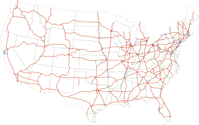
English: (Outdated) Map of the Interstate Highway System in the United States
Labels:
One or Two-digit interstates
(dark orange line)
Selected three-digit interstates
(blue line)
Selected planned interstates
(green dashed line)
วันที่
แหล่งที่มา
National Atlas
ผู้สร้างสรรค์
SPUI
การอนุญาตใช้สิทธิ
Public domainPublic domainfalsefalse
Annotations
InfoField
This image is annotated: View the annotations at Commons
{{spuimap}} Map of the present Interstate Highway System. Base map is [http://www.nationalatlas.gov/printable/images/pdf/reference/genref.pdf] (public domain US Federal Government). *Purple: two-digit *Blue: selected three-digit *Green: selected future ro
ไฟล, current, interstates, ไฟล, ประว, ไฟล, หน, าท, ภาพน, การใช, ไฟล, วนกลาง, อม, ลเก, ยวก, บภาพขนาดของต, วอย, าง, ของไฟล, กเซล, ความละเอ, ยดอ, กเซล, กเซล, กเซล, กเซล, กเซล, ภาพท, ความละเอ, ยดส, งกว, 8206, ไฟล, กเซล, ขนาดไฟล, โลไบต, ปภาพหร, อไฟล, เส, ยงน, นฉบ, . ifl prawtiifl hnathimiphaphni karichiflswnklang khxmulekiywkbphaphkhnadkhxngtwxyang PNG nikhxngifl SVG ni 689 432 phikesl khwamlaexiydxun 320 201 phikesl 640 401 phikesl 1 024 642 phikesl 1 280 803 phikesl 2 560 1 605 phikesl duphaphthimikhwamlaexiydsungkwa 8206 ifl SVG 689 432 phikesl khnadifl 518 kiolibt rupphaphhruxiflesiyngni tnchbbxyuthi khxmmxns raylaexiyddanlang epnkhxkhwamthiaesdngphlcak ifltnchbbinkhxmmxns khxmmxnsepnewbistinokhrngkarsahrbekbrwbrwmsuxesri thi khunsamarthchwyid This file requires updating because Multiple Interstates and future Interstate are Missing In doing so you could add a timestamp to the file Please notify the uploader with code subst update note 1 File Map of current Interstates svg 2 Multiple Interstates and future Interstate are Missing code khwamyx khaxthibayMap of current Interstates svg English Outdated Map of the Interstate Highway System in the United States Labels nbsp One or Two digit interstates dark orange line nbsp Selected three digit interstates blue line nbsp Selected planned interstates green dashed line wnthi 13 krkdakhm ph s 2549 aehlngthima National Atlas phusrangsrrkh SPUI karxnuyatichsiththi Public domain Public domain false false nganniidthukephyaephrsusatharnsmbtiodyecakhxng SPUI sungmiphlthwolk inbangpraeths karkrathadngklawxacimsamarththaidtamkdhmay SPUI xnuyatihthukkhnmisiththiinkarichiflniinthukehtuphlkarich odyimmimienguxnikh ewnaetkdhmayimxnuyatihthaechnnn AnnotationsInfoFieldThis image is annotated View the annotations at Commons622 143 8 8 689 432 Nueva YorkkhabrryayodyyxithyephimkhabrryaythrrthdediywephuxkhyaykhwamwaiflnimixairxngkvsInterstate highway systemopaelndMapa przedstawiajaca siatke autostrad w USArsesiySistema mezhshtatnyh avtomagistralej SShAixethmthiaesdngxyuiniflniprakxbdwyphusrangbangkhathiimmiixethmwikisnethsyuxaraexl https commons wikimedia org wiki user SPUI 7Ecommonswikichuxphuichwikimiediy SPUI commonswikichuxphusrangsrrkh SPUIsthanalikhsiththicopyrighted dedicated to the public domain by copyright holder nbsp xngkvssyyaxnuyatreleased into the public domain by the copyright holder nbsp xngkvswnthisrang wnkxtng13 krkdakhm 2006MIME type nbsp xngkvsimage svg xml prawtiifl khlikwnthi ewlaephuxduiflthipraktinkhnann wnthi ewlarupyxkhnadphuichkhwamehn pccubn18 19 13 kumphaphnth 2556689 432 518 kiolibt Scott5114Add I 49 in Missouri 13 39 11 mkrakhm 2556689 432 519 kiolibt Agricolaeadd I 376 rebranding north to I 80 planned I 99 from I 80 to I 86 14 27 2 krkdakhm 2554689 432 485 kiolibt JkirkuslamontChanged hues to improve legibility for the colour blind 11 36 10 mkrakhm 2553689 432 754 kiolibt Techman224Made three dight Interstates near Atlanta Georgia blue 04 32 24 thnwakhm 2552689 432 754 kiolibt Cloroxadded I69 13 12 29 kumphaphnth 2551689 432 744 kiolibt Alex43223Updated a couple highways 09 38 22 mithunayn 2550689 432 687 kiolibt Fran RogersReverted to earlier revision 09 37 22 mithunayn 2550689 432 687 kiolibt Fran Rogers spuimap Map of the present Interstate Highway System Base map is http www nationalatlas gov printable images pdf reference genref pdf public domain US Federal Government Purple two digit Blue selected three digit Green selected future ro 23 07 13 krkdakhm 2549689 432 687 kiolibt SPUI commonswiki spuimap hnathimiphaphni hnatxipni oyngmathiphaphni rabbthanghlwngxinetxrsett shrth karichiflswnklang wikixuntxipniichiflni karichbn an wikipedia org Estaus Unius karichbn ar wikipedia org الولايات المتحدة karichbn ast wikipedia org Sistema Interestatal d Autopistes karichbn az wikipedia org Amerika Birlesmis Statlari karichbn bg wikipedia org Sedineni amerikanski shati Mezhdushatska magistralna sistema karichbn bs wikipedia org Autoput karichbn ca wikipedia org Escandol dels tramvies dels Estats Units Sistema Interestatal d Autopistes dels Estats Units karichbn da wikipedia org USA Interstate Highway System karichbn de wikipedia org Liste der Interstate Highways Interstate Highway Vereinigte Staaten New Yorker Hafen Benutzer Diefarbeblau Archiv Ostkuste karichbn en wikipedia org Economy of the United States Transportation in the United States List of gaps in Interstate Highways List of auxiliary Interstate Highways Controlled access highway List of business routes of the Interstate Highway System User Master son US Roads User Master son US Roads MTF Wikipedia talk External links Driving in the United States Trucking industry in the United States 1956 in the United States List of transport megaprojects User Stephen100002 sandbox User Vigneshdm1990 sandbox User 44Nifty sandbox User XanUltra Transportation policy of the United States Talk United States Archive 102 Portal Transport Highway media Wikipedia Village pump technical Archive 208 karichbn en wikibooks org Transportation Deployment Casebook Interstate Highway System Transportation Deployment Casebook Printable version karichbn eo wikipedia org Interŝtata Ŝosea Sistemo Usono karichbn es wikipedia org Sistema Interestatal de Autopistas Estados Unidos karichbn et wikipedia org Interstate Highway System Ameerika Uhendriikide majandus karichbn eu wikipedia org Zerrenda Ameriketako Estatu Batuetako estatuarteko autobideak Estatuarteko Autobide Sistema karichbn fa wikipedia org ایالات متحده آمریکا سامانه بزرگراه های میان ایالتی karichbn fi wikipedia org Interstate Highway System dukarichthwolkephimetimkhxngiflnikhxmulekiywkbphaph phaphnimikhxmulephimetim sungswnihymacakklxngdicitxlhruxsaeknenxrthisamarthekbkhxmuldngklawiwrwmkbphaphid thaphaphnithukprbprungaekikhhruxepliynaeplngcakedim khxmulbangxyangcayngkhngimepliynaeplngehmuxnphaphthithukprbprungaekikhnnkhwamkwang689 459pxkhwamsung432 441px ekhathungcak https th wikipedia org wiki ifl Map of current Interstates svg, wikipedia, วิกิ หนังสือ, หนังสือ, ห้องสมุด,