ภาพแผนที่นี้ ควรจะถูกสร้างใหม่เป็นกราฟิกส์เวกเตอร์ ซึ่งมีข้อดีอีกหลายประการ ดูเพิ่มเติมที่คอมมอนส์:สื่อต้องการเก็บกวาดสำหรับสารสนเทศเพิ่มเติม หากภาพนี้มีในรูปแบบกราฟิกส์เวกเตอร์อยู่แล้ว กรุณาอัปโหลดและแทนที่แม่แบบนี้ด้วย {{vector version available|ชื่อภาพใหม่}} แนะนำเป็นอย่างยิ่งให้ตั้งชื่อไฟล์เวกเตอร์ใหม่นั้นในรูปแบบ "Map of the Holy Roman Empire, 1789 en.svg" แล้วใส่แม่แบบ Vector version available (หรือ Vva) ซึ่งไม่ต้องใช้พารามิเตอร์ ชื่อภาพใหม่
ความย่อ
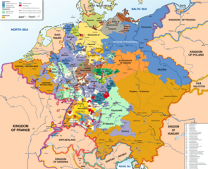
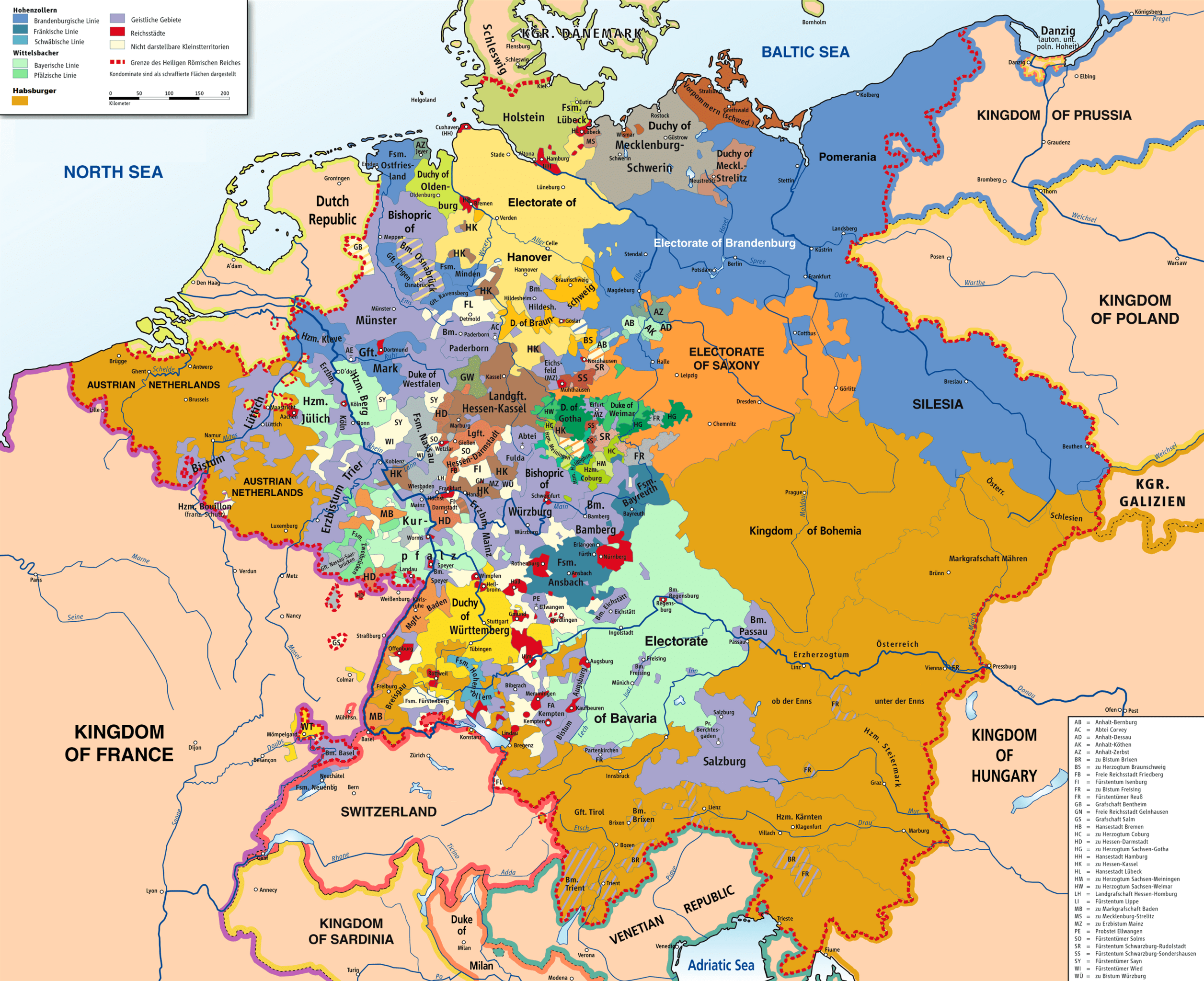
คำอธิบายMap of the Holy Roman Empire, 1789 en.png
English: Map of the Holy Roman Empire, 1789.
วันที่
แหล่งที่มา
Own work based on: HRR 1789.png "translated (somewhat) from original German version"
References:
Putzger, F. W. (พ.ศ. 2508) Historischer Weltatlas (ที่๘๙ ed.)
(พ.ศ. 2512) Westermanns Großer Atlas zur Weltgeschichte, Georg Westermann Verlag
Haacks geographischer Atlas. VEB Hermann Haack Geographisch-Kartographische Anstalt, Gotha/Leipzig, 1. Auflage, 1979
Kinder, Hermann (พ.ศ. 2532) Dtv-Atlas Weltgeschichte / 2, Von der Französischen Revolution bis zur Gegenwart. (ที่๒๓ ed.), มิวนิก: Dt. Taschenbuch-Verl ISBN: 3-423-03002-X. OCLC: 313766861.
I've added a few more English place names, as follows: Wien > Vienna Muenchen > Munich Mailand > Milan Bruessel > Brussels Prag > Prague Antwerpen > Antwerp Triest > Trieste Warschau > Warsaw Gent > Ghent Erzbistum removed from Salzburg; should be Ar...
{{Information |Description={{en|1=Map of the Holy Roman Empire, 1789, translated (somewhat) from original German version on Wikipedia Commons}} |Source=Own source, translated map from Image:HRR 1789.png, also on WC |Author=Robert Alfers, [[:de:Benutzer:kg
ไฟล, holy, roman, empire, 1789, ไฟล, ประว, ไฟล, หน, าท, ภาพน, การใช, ไฟล, วนกลางขนาดของต, วอย, างน, กเซล, ความละเอ, ยดอ, กเซล, กเซล, กเซล, กเซล, กเซล, กเซล, ภาพท, ความละเอ, ยดส, งกว, 8206, กเซล, ขนาดไฟล, โลไบต, ชน, ดไมม, image, ปภาพหร, อไฟล, เส, ยงน, นฉบ, บอย,. ifl prawtiifl hnathimiphaphni karichiflswnklangkhnadkhxngtwxyangni 736 600 phikesl khwamlaexiydxun 295 240 phikesl 589 480 phikesl 942 768 phikesl 1 256 1 024 phikesl 2 513 2 048 phikesl 2 650 2 160 phikesl duphaphthimikhwamlaexiydsungkwa 8206 2 650 2 160 phikesl khnadifl 726 kiolibt chnidimm image png rupphaphhruxiflesiyngni tnchbbxyuthi khxmmxns raylaexiyddanlang epnkhxkhwamthiaesdngphlcak ifltnchbbinkhxmmxns khxmmxnsepnewbistinokhrngkarsahrbekbrwbrwmsuxesri thi khunsamarthchwyid phaphaephnthini khwrcathuksrangihmepnkrafiksewketxr sungmikhxdixikhlayprakar duephimetimthikhxmmxns suxtxngkarekbkwadsahrbsarsnethsephimetim hakphaphnimiinrupaebbkrafiksewketxrxyuaelw krunaxpohldaelaaethnthiaemaebbnidwy vector version available i chuxphaphihm i aenanaepnxyangyingihtngchuxiflewketxrihmnninrupaebb Map of the Holy Roman Empire 1789 en svg aelwisaemaebb Vector version available hrux Vva sungimtxngichpharamietxr chuxphaphihmkhwamyx khaxthibayMap of the Holy Roman Empire 1789 en png English Map of the Holy Roman Empire 1789 wnthi 8 mithunayn ph s 2551aehlngthima Own work based on HRR 1789 png translated somewhat from original German version References Putzger F W ph s 2508 Historischer Weltatlas thi89 ed ph s 2512 Westermanns Grosser Atlas zur Weltgeschichte Georg Westermann Verlag Haacks geographischer Atlas VEB Hermann Haack Geographisch Kartographische Anstalt Gotha Leipzig 1 Auflage 1979 Kinder Hermann ph s 2532 Dtv Atlas Weltgeschichte 2 Von der Franzosischen Revolution bis zur Gegenwart thi23 ed miwnik Dt Taschenbuch Verl ISBN 3 423 03002 X OCLC 313766861 phusrang Robert Alfers ziegelbrennerphikdxangxingthangphumisastr rabuphikdbnaephnthi Wikimaps Warper thamikhwamimehmaasm krunatng warp status skip ephuxsxnewxrchnxun German original karxnuyatichsiththi iflnixyuphayitsyyaxnuyatkhriexthifkhxmmxns runaesdngthima xnuyataebbediywkn 3 0 tnchbb 2 5 thwip 2 0 thwip aela 1 0 thwipkhunsamarth thicaaebngpn thicathasaena aeckcay aelasngngandngklawtxip thicaeriyberiyngihm thicaddaeplngngandngklaw phayitenguxnikhtxipni aesdngthima khuntxngihekiyrtiecakhxngnganxyangehmaasm odyephimlingkipyngsyyaxnuyat aelarabuhakmikarepliynaeplng khunxacthaechnniidinrupaebbidkidtamkhwr aettxngimichinlksnathiaenawaphuihxnuyatsnbsnunkhunhruxkarichngankhxngkhun xnuyataebbediywkn hakkhunddaeplng epliynrup hruxtxetimnganni khuntxngichsyyaxnuyataebbediywknhruxaebbthiehmuxnkbsyyaxnuyatthiichkbnganniethannhttps creativecommons org licenses by sa 3 0 CC BY SA 3 0 Creative Commons Attribution Share Alike 3 0 true truekhabrryayodyyxithyephimkhabrryaythrrthdediywephuxkhyaykhwamwaiflnimixairixethmthiaesdngxyuiniflniprakxbdwysthanalikhsiththimilikhsiththisyyaxnuyatCreative Commons Attribution ShareAlike 3 0 Unported xngkvsCreative Commons Attribution ShareAlike 2 0 Generic xngkvsCreative Commons Attribution ShareAlike 2 5 Generic xngkvsCreative Commons Attribution ShareAlike 1 0 Generic xngkvswnthisrang wnkxtng8 mithunayn 2008 prawtiifl khlikwnthi ewlaephuxduiflthipraktinkhnann wnthi ewlarupyxkhnadphuichkhwamehn pccubn21 47 30 phvscikayn 25612 650 2 160 726 kiolibt FDRMRZUSAImplemented map legend inserted Kilometers 05 59 30 phvscikayn 25612 650 2 160 810 kiolibt FDRMRZUSAImplemented map legend Habsburger Reduced dimensions size 23 17 17 kumphaphnth 25562 650 2 160 2 69 emkaibt Opus33I 039 ve added a few more English place names as follows Wien gt Vienna Muenchen gt Munich Mailand gt Milan Bruessel gt Brussels Prag gt Prague Antwerpen gt Antwerp Triest gt Trieste Warschau gt Warsaw Gent gt Ghent Erzbistum removed from Salzburg should be Ar 00 08 3 krkdakhm 25532 650 2 160 2 55 emkaibt Ras67cropped 11 09 8 mithunayn 25512 659 2 170 2 62 emkaibt RobNS Information Description en 1 Map of the Holy Roman Empire 1789 translated somewhat from original German version on Wikipedia Commons Source Own source translated map from Image HRR 1789 png also on WC Author Robert Alfers de Benutzer kg hnathimiphaphni hnatxipni oyngmathiphaphni karptirupdinaednineyxrmni rthkhxngckrwrrdiormnxnskdisiththi irchsxunmithethilbarikhth karichiflswnklang wikixuntxipniichiflni karichbn als wikipedia org Reichsunmittelbarkeit karichbn ar wikipedia org الإمبراطورية الفورية الوساطة الألمانية كلاينشتاتراي karichbn azb wikipedia org موقدس روم ژرمن ایمپراتورلوغو karichbn az wikipedia org Almaniyanin birlesdirilmesi 1871 karichbn be wikipedia org Svyashchennaya Rymskaya imperyya Germanskaya medyyatyzacyya karichbn bg wikipedia org Germanska mediatizaciya karichbn cs wikipedia org Svata rise rimska Sjednoceni Nemecka Mediatizace karichbn da wikipedia org Fyrstbispedommet Bamberg karichbn de wikipedia org Diskussion Konigreich Preussen Archiv 1 karichbn el wikipedia org Agia Rwmaikh Aytokratoria karichbn en wikipedia org Holy Roman Empire Battle of Rastatt 1796 Imperial immediacy Unification of Germany German mediatisation Kleinstaaterei Names of Germany Army of Sambre and Meuse Talk Holy Roman Empire Archive 1 Austria Germany relations Siege of Kehl 1796 1797 Wikipedia Graphics Lab Map workshop Archive Dec 2012 Nationality of Wolfgang Amadeus Mozart Rhine campaign of 1796 User Dainomite sandbox Dissolution of the Holy Roman Empire Rhine campaign of 1795 Battle of Kehl 1796 Siege of Huningen 1796 1797 Wikipedia Village pump technical Archive 144 Early clashes in the Rhine campaign of 1796 User Falcaorib User Bunhouse768 sandbox karichbn es wikipedia org Sacro Imperio Romano Germanico Mediatizacion y secularizacion Kleinstaaterei Francisco Alejandro Nebel Disolucion del Sacro Imperio Romano Germanico Relaciones Alemania Austria karichbn et wikipedia org Kleinstaaterei Saksamaa mediatisatsioon karichbn gl wikipedia org Mediatizacion e secularizacion Kleinstaaterei karichbn he wikipedia org יחסי אוסטריה גרמניה karichbn hy wikipedia org Սրբազան Հռոմեական կայսրություն dukarichthwolkephimetimkhxngiflni ekhathungcak https th wikipedia org wiki ifl Map of the Holy Roman Empire 1789 en png, wikipedia, วิกิ หนังสือ, หนังสือ, ห้องสมุด,