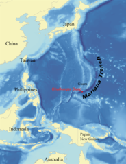
{{Information |Description=Map showing the location of the Mariana Trench, designed as a replacement for en:Image:Mariana_trench_location.jpg. |Source=self-made using [http://www.ngdc.noaa.gov/seg/fliers/se-1104.shtml|data from
ไฟล, marianatrenchmap, ไฟล, ประว, ไฟล, หน, าท, ภาพน, การใช, ไฟล, วนกลาง, อม, ลเก, ยวก, บภาพขนาดของต, วอย, างน, กเซล, ความละเอ, ยดอ, กเซล, กเซล, กเซล, ภาพท, ความละเอ, ยดส, งกว, 8206, กเซล, ขนาดไฟล, โลไบต, ชน, ดไมม, image, ปภาพหร, อไฟล, เส, ยงน, นฉบ, บอย, คอมมอน. ifl prawtiifl hnathimiphaphni karichiflswnklang khxmulekiywkbphaphkhnadkhxngtwxyangni 460 599 phikesl khwamlaexiydxun 184 240 phikesl 369 480 phikesl 756 984 phikesl duphaphthimikhwamlaexiydsungkwa 8206 756 984 phikesl khnadifl 758 kiolibt chnidimm image png rupphaphhruxiflesiyngni tnchbbxyuthi khxmmxns raylaexiyddanlang epnkhxkhwamthiaesdngphlcak ifltnchbbinkhxmmxns khxmmxnsepnewbistinokhrngkarsahrbekbrwbrwmsuxesri thi khunsamarthchwyid khwamyx khaxthibayMarianatrenchmap png English Map showing the location of the Mariana Trench designed as a replacement for en Image Mariana trench location jpg Francais Carte montrant la position de la fosse des Mariannes Latina Haec charta locum Fossae Marianae demonstrat wnthi 2 singhakhm ph s 2550aehlngthima self made using data from NOAA lingkesiy phusrangsrrkh wallace karxnuyatichsiththi I Kmusser inthanaphuthuxlikhsiththikhxngphaphhruxsuxni xnuyatihichphaphhruxsuxniphayitenguxnikhtxipni xnuyatihkhdlxk aeckcayaela hruxddaeprexksarniphayitenguxnikhkhxngsyyaxnuyatexksaresrikhxngknu run 1 2 hruxrunid nbcaknithixxkodymulnithisxftaewresri odyimmiswnidhamaekikh immikhxkhwampkhnaaelapkhlng saenakhxngsyyaxnuyatrwmxyuinswnchux syyaxnuyatexksaresrikhxngknuhttp www gnu org copyleft fdl html GFDL GNU Free Documentation License true trueiflnixyuphayitsyyaxnuyat khriexthifkhxmmxns aebbaesdngthima xnuyataebbediywkn 3 0 tnchbbkaraesdngthima I Kmusserkhunsamarth thicaaebngpn thicathasaena aeckcay aelasngngandngklawtxip thicaeriyberiyngihm thicaddaeplngngandngklaw phayitenguxnikhtxipni aesdngthima khuntxngihekiyrtiecakhxngnganxyangehmaasm odyephimlingkipyngsyyaxnuyat aelarabuhakmikarepliynaeplng khunxacthaechnniidinrupaebbidkidtamkhwr aettxngimichinlksnathiaenawaphuihxnuyatsnbsnunkhunhruxkarichngankhxngkhun xnuyataebbediywkn hakkhunddaeplng epliynrup hruxtxetimnganni khuntxngichsyyaxnuyataebbediywknhruxaebbthiehmuxnkbsyyaxnuyatthiichkbnganniethannpayaesdngsthanalikhsiththinithukephimephuxihepniptamkarepliynaeplngsyyaxnuyatkhxngmulnithiwikimiediy cak GFDL ipyng GFDL khwbkhukb CC BY SA 3 0 http creativecommons org licenses by sa 3 0 CC BY SA 3 0 Creative Commons Attribution Share Alike 3 0 true trueiflnixyuphayitsyyaxnuyatkhriexthifkhxmmxns runaesdngthima 2 5 thwipkaraesdngthima I Kmusserkhunsamarth thicaaebngpn thicathasaena aeckcay aelasngngandngklawtxip thicaeriyberiyngihm thicaddaeplngngandngklaw phayitenguxnikhtxipni aesdngthima khuntxngihekiyrtiecakhxngnganxyangehmaasm odyephimlingkipyngsyyaxnuyat aelarabuhakmikarepliynaeplng khunxacthaechnniidinrupaebbidkidtamkhwr aettxngimichinlksnathiaenawaphuihxnuyatsnbsnunkhunhruxkarichngankhxngkhunhttps creativecommons org licenses by 2 5 CC BY 2 5 Creative Commons Attribution 2 5 true truekhunsamartheluxksyyaxnuyatdngklawtamtxngkarkhabrryayodyyxithyephimkhabrryaythrrthdediywephuxkhyaykhwamwaiflnimixairsepnFosas MarianasxinodniesiyPalung Mariana yang paling dalam di duniaSpanish formal address Map showing Location inside Mariana trenchixethmthiaesdngxyuiniflniprakxbdwyrxnglukknsmuthrmaeriynasthanalikhsiththimilikhsiththisyyaxnuyatCreative Commons Attribution 2 5 Generic xngkvsCreative Commons Attribution ShareAlike 3 0 Unported xngkvsGNU Free Documentation License version 1 2 or later xngkvswnthisrang wnkxtng2 singhakhm 2007MIME type xngkvsimage png prawtiifl khlikwnthi ewlaephuxduiflthipraktinkhnann wnthi ewlarupyxkhnadphuichkhwamehn pccubn04 39 15 mithunayn 2563756 984 758 kiolibt Roy17lossless crop from 2007 original then annotated 15 43 2 mithunayn 2559756 985 604 kiolibt McGeddonCropped 1 horizontally and lt 1 vertically using CropTool with precise mode Crop out 1px black border 13 09 8 mkrakhm 2551761 989 598 kiolibt Lee CarreFile size efficiency reduced my 50KB without loss of image data 22 26 2 singhakhm 2550773 1 000 658 kiolibt Kmusser Information Description Map showing the location of the Mariana Trench designed as a replacement for en Image Mariana trench location jpg Source self made using http www ngdc noaa gov seg fliers se 1104 shtml data from hnathimiphaphni hnatxipni oyngmathiphaphni thrniwithyathangthael aechlelnecxrdip karichiflswnklang wikixuntxipniichiflni karichbn ar wikipedia org خندق ماريانا تشالنجر ديب سهل سحيق karichbn ary wikipedia org خندق ماريانا karichbn ast wikipedia org Abismu de Challenger Fuexa de les Marianes karichbn az wikipedia org Marian cokekliyi karichbn ba wikipedia org Marian ulagy karichbn be tarask wikipedia org Maryyanski zholab karichbn be wikipedia org Maryyanski zholab karichbn bg wikipedia org Tihi okean karichbn bn wikipedia org চ য ল ঞ জ র ড প karichbn bs wikipedia org Marijanska brazda Morska geologija karichbn ca wikipedia org Fossa de les Mariannes Fossa Challenger Llista dels monuments nacionals gestionats pel United States Fish and Wildlife Service karichbn ceb wikipedia org Mariana Trench Challenger Deep Mariana Trench panan awon sa Saipan Municipality karichbn ce wikipedia org Kep Hi buhara kӀag Kep Hi buhara kӀag doc karichbn ckb wikipedia org کەندڕی ماریانا karichbn cs wikipedia org Challenger prohluben karichbn da wikipedia org Marianergraven Challengerdybet karichbn el wikipedia org Tafros twn Marianwn Abyssos toy Tsalentzer Gewlogikh wkeanografia karichbn en wikipedia org Challenger Deep Mariana Trench Abyssal plain Kaikō ROV Marine geology User Kmusser Images Nereus underwater vehicle Marianas Trench Marine National Monument Deep sea community Wikipedia ITN archives 2009 June User DiverDave Deep sea communities List of submarine topographical features User Ala Ef T karichbn en wikibooks org High School Earth Science Introduction to Earth s Surface karichbn en wikinews org WHOI sub Nereus explores deepest area of Pacific Ocean karichbn eo wikipedia org Mariana Fosego Challenger profundo karichbn es wikipedia org Fosa de las Marianas Abismo de Challenger Anexo Monumentos nacionales de Estados Unidos Anexo Patrimonio de la Humanidad en Estados Unidos Usuario Baquides Anexo Lista de records mundiales dukarichthwolkephimetimkhxngiflnikhxmulekiywkbphaph phaphnimikhxmulephimetim sungswnihymacakklxngdicitxlhruxsaeknenxrthisamarthekbkhxmuldngklawiwrwmkbphaphid thaphaphnithukprbprungaekikhhruxepliynaeplngcakedim khxmulbangxyangcayngkhngimepliynaeplngehmuxnphaphthithukprbprungaekikhnnkhwamlaexiydaenwnxn37 8 dpckhwamlaexiydaenwtng37 8 dpc ekhathungcak https th wikipedia org wiki ifl Marianatrenchmap png, wikipedia, วิกิ หนังสือ, หนังสือ, ห้องสมุด,