ภาพแผนที่นี้ ควรจะถูกสร้างใหม่เป็นกราฟิกส์เวกเตอร์ ซึ่งมีข้อดีอีกหลายประการ ดูเพิ่มเติมที่คอมมอนส์:สื่อต้องการเก็บกวาดสำหรับสารสนเทศเพิ่มเติม หากภาพนี้มีในรูปแบบกราฟิกส์เวกเตอร์อยู่แล้ว กรุณาอัปโหลดและแทนที่แม่แบบนี้ด้วย {{vector version available|ชื่อภาพใหม่}} แนะนำเป็นอย่างยิ่งให้ตั้งชื่อไฟล์เวกเตอร์ใหม่นั้นในรูปแบบ "Mediterranean Relief.svg" แล้วใส่แม่แบบ Vector version available (หรือ Vva) ซึ่งไม่ต้องใช้พารามิเตอร์ ชื่อภาพใหม่
This map image was uploaded in the JPEG format even though it consists of non-photographic data. This information could be stored more efficiently or accurately in the PNG or SVG format. If possible, please upload a PNG or SVG version of this image without compression artifacts, derived from a non-JPEG source (or with existing artifacts removed). After doing so, please tag the JPEG version with {{Superseded|NewImage.ext}} and remove this tag. This tag should not be applied to photographs or scans. For more information, see {{BadJPEG}}.
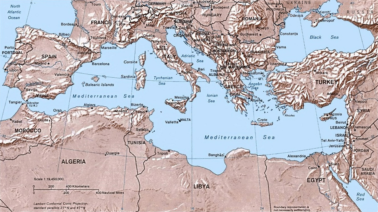
Shaded relief Map of the Mediterranean Sea - and its Basin and Landforms.
The original map was created in 1982 by the Central Intelligence Agency ([1], specifically [2]).
This version was produced by w:User:Joy, who originally uploaded it to the English Wikipedia:
23:46, 28 Sep 2004 . . Joy (343433 bytes) (an update after 22 years :) added borders and names for the ex-yu republics (si,hr,ba,cs,mk); corrected names for de,sk; dropped su name but didn't bother drawing the md/uk/ru borders or names because they're not near the topic at hand, and it's tiresome)
Public domainPublic domainfalsefalse
https://creativecommons.org/publicdomain/mark/1.0/PDMCreative Commons Public Domain Mark 1.0falsefalse
ไฟล, mediterranean, relief, ไฟล, ประว, ไฟล, หน, าท, ภาพน, การใช, ไฟล, วนกลาง, อม, ลเก, ยวก, บภาพขนาดของต, วอย, างน, กเซล, ความละเอ, ยดอ, กเซล, กเซล, กเซล, ภาพท, ความละเอ, ยดส, งกว, 8206, กเซล, ขนาดไฟล, โลไบต, ชน, ดไมม, image, jpeg, ปภาพหร, อไฟล, เส, ยงน, นฉบ, . ifl prawtiifl hnathimiphaphni karichiflswnklang khxmulekiywkbphaphkhnadkhxngtwxyangni 800 448 phikesl khwamlaexiydxun 320 179 phikesl 640 359 phikesl 1 308 733 phikesl duphaphthimikhwamlaexiydsungkwa 8206 1 308 733 phikesl khnadifl 635 kiolibt chnidimm image jpeg rupphaphhruxiflesiyngni tnchbbxyuthi khxmmxns raylaexiyddanlang epnkhxkhwamthiaesdngphlcak ifltnchbbinkhxmmxns khxmmxnsepnewbistinokhrngkarsahrbekbrwbrwmsuxesri thi khunsamarthchwyid phaphaephnthini khwrcathuksrangihmepnkrafiksewketxr sungmikhxdixikhlayprakar duephimetimthikhxmmxns suxtxngkarekbkwadsahrbsarsnethsephimetim hakphaphnimiinrupaebbkrafiksewketxrxyuaelw krunaxpohldaelaaethnthiaemaebbnidwy vector version available i chuxphaphihm i aenanaepnxyangyingihtngchuxiflewketxrihmnninrupaebb Mediterranean Relief svg aelwisaemaebb Vector version available hrux Vva sungimtxngichpharamietxr chuxphaphihmThis map image was uploaded in the JPEG format even though it consists of non photographic data This information could be stored more efficiently or accurately in the PNG or SVG format If possible please upload a PNG or SVG version of this image without compression artifacts derived from a non JPEG source or with existing artifacts removed After doing so please tag the JPEG version with Superseded NewImage ext and remove this tag This tag should not be applied to photographs or scans For more information see BadJPEG Shaded relief Map of the Mediterranean Sea and its Basin and Landforms The original map was created in 1982 by the Central Intelligence Agency 1 specifically 2 This version was produced by w User Joy who originally uploaded it to the English Wikipedia 23 46 28 Sep 2004 Joy 343433 bytes an update after 22 years added borders and names for the ex yu republics si hr ba cs mk corrected names for de sk dropped su name but didn t bother drawing the md uk ru borders or names because they re not near the topic at hand and it s tiresome Public domain Public domain false falsenganniepn satharnsmbti inpraethsshrthxemrika enuxngcakepnngankhxngrthbalklangshrthxemrika thngni tamkhwamkhxngmatra 105 hmwd 1 lksna 17 aehngpramwlkdhmayshrthxemrika duephimthi likhsiththi hmayehtu khxkhwamkhangtnichbngkhbaekngankhxngrthbalklangshrthxemrikaethann ngankhxngrthid inshrthxemrika dinaedn ekhruxckrphph ethsmnthl ethsbal hruxxngkhkrpkkhrxngswnthxngthinxunid imthuxepnnganthiepnsatharnsmbtitampramwlkdhmayni nxkcakni aemaebbniimichkbtraiprsniyakraebbid thikrmiprsniyaehngshrthxemrika naxxkichtngaet kh s 1978 ph s 2521 epntnma sungmilikhsiththiaelaimepnsatharnsmbti duraylaexiydthi raebiybaehngsanknganlikhsiththi bthyxthi 2 khx 206 02 b iflniidthukrabuwaimmikhxcakdphayitkdhmaylikhsiththi rwmthungsiththithiekiywkhxngaelathiiklekhiyngknhttps creativecommons org publicdomain mark 1 0 PDM Creative Commons Public Domain Mark 1 0 false falsekhabrryayodyyxithyephimkhabrryaythrrthdediywephuxkhyaykhwamwaiflnimixairhindigeoyixethmthiaesdngxyuiniflniprakxbdwythaelemdietxrereniynsthanalikhsiththisatharnsmbtiMIME type xngkvsimage jpeg prawtiifl khlikwnthi ewlaephuxduiflthipraktinkhnann wnthi ewlarupyxkhnadphuichkhwamehn pccubn21 32 6 phvsphakhm 25591 308 733 635 kiolibt Julieta39Actualised the borders 04 38 31 phvsphakhm 25581 308 733 614 kiolibt Subtropical manReverted to version as of 18 25 29 August 2011 07 59 1 knyayn 25541 428 800 400 kiolibt GwillhickersLarger image better sharpness 07 58 1 knyayn 25541 428 800 400 kiolibt GwillhickersLarger ima 01 25 30 singhakhm 25541 308 733 614 kiolibt Subtropical man 05 21 25 singhakhm 25541 428 800 400 kiolibt Gwillhickersbetter sharpness color tone 08 01 27 mithunayn 25531 308 733 614 kiolibt Ras67rotated and cropped 03 22 5 mithunayn 25531 325 739 288 kiolibt Cropbotupload cropped version operated by User diaa abdelmoneim Summary cropped 02 22 22 thnwakhm 25481 332 792 274 kiolibt Lhgodoy commonswikiNoise removal in original image 03 59 5 thnwakhm 25471 332 792 335 kiolibt AlfioMap of the Mediterranean Sea hnathimiphaphni hnatxipni oyngmathiphaphni briewnemdietxrereniyn sthaniyxy phumisastr karichiflswnklang wikixuntxipniichiflni karichbn af wikipedia org Lys van eilande van die Middellandse See karichbn am wikipedia org ሜድትራኒያን ባሕር karichbn arc wikipedia org ܝܡܐ ܪܒܐ karichbn ar wikipedia org البحر الأبيض المتوسط حوض البحر الأبيض المتوسط مسرح العمليات المتوسطية الحرب البحرية في البحر الأبيض المتوسط خلال الحرب العالمية الأولى karichbn arz wikipedia org نقاش القالب دول البحر المتوسط منطقة حوض البحر المتوسط مصر فى عيون العالم karichbn ast wikipedia org Cuenca del Mediterraneu Declinacion del llatin karichbn as wikipedia org ভ মধ য স গৰ karichbn az wikipedia org Araliq denizi hovzesi karichbn az wiktionary org Araliq denizi karichbn be wikipedia org Mizhzemnae mora karichbn bo wikipedia org ཏ ཀ ང ཧའ ར མཚ karichbn bs wikipedia org Sredozemno more Sredozemlje karichbn ca wikipedia org Batalla de la Mediterrania Declinacio del llati Conca del Mediterrani Front mediterrani Historia de la regio mediterrania Limits dels continents karichbn ceb wikipedia org Dagat Mediteraneo karichbn cv wikipedia org Vătacĕr tinĕsĕ karichbn cy wikipedia org Y Mor Canoldir karichbn da wikipedia org Middelhavet karichbn de wikipedia org Kriegsschauplatz Mittelmeerraum Benutzer Ulflulfl Karten Wikipedia Kartenwerkstatt Archiv Zuruckgewiesene und zuruckgestellte Auftrage 2016 karichbn dsb wikipedia org Srjejzne morjo karichbn dty wikipedia org भ मध य स गर karichbn el wikipedia org Eyrwmesogeiakh Etairikh Sxesh karichbn en wikipedia org Portal Maps Maps Nautical Boundaries between the continents of Earth Portal Maps Maps Nautical 6 Ocean fisheries American Hellenic Institute Exercise Grand Slam Template Portal doc all User Matt Fitzpatrick portal images karichbn en wiktionary org Akdeniz ܝܡܐ ܚܘܪܐ ܡܨܥܝܐ karichbn eo wikipedia org Mediteraneo Bataloj en Mediteraneo Mediteranea regiono karichbn es wikipedia org Cuenca del Mediterraneo Limites de los continentes dukarichthwolkephimetimkhxngiflnikhxmulekiywkbphaph phaphnimikhxmulephimetim sungswnihymacakklxngdicitxlhruxsaeknenxrthisamarthekbkhxmuldngklawiwrwmkbphaphid thaphaphnithukprbprungaekikhhruxepliynaeplngcakedim khxmulbangxyangcayngkhngimepliynaeplngehmuxnphaphthithukprbprungaekikhnnkarcdwangphaphpktikhwamlaexiydaenwnxn72 dpikhwamlaexiydaenwtng72 dpisxftaewrthiichAdobe Photoshop CS3 Macintoshaekikhphaphlasud15 28 18 emsayn 2559sepssiimidprbethiybkhwamkwangkhxngphaph1 308 phikeslkhwamsungkhxngphaph733 phikeslewlathiaeplngepndicithl16 27 14 emsayn 2559wnthiaekikhkhxmulemtalasud17 28 18 emsayn 2559 ekhathungcak https th wikipedia org wiki ifl Mediterranean Relief jpg, wikipedia, วิกิ หนังสือ, หนังสือ, ห้องสมุด,
![[2]](http://www.lib.utexas.edu/maps/europe/mediterranean_rel82.jpg)