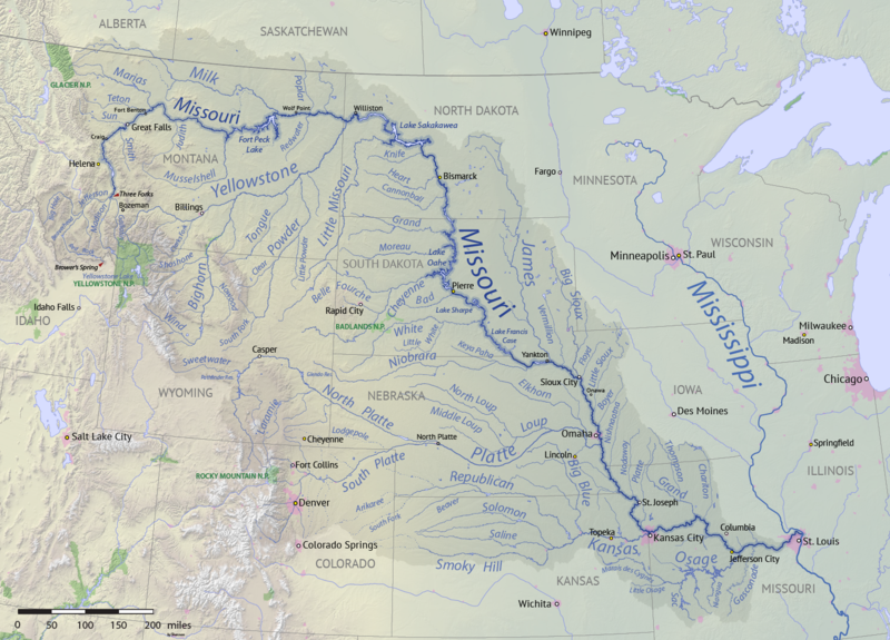
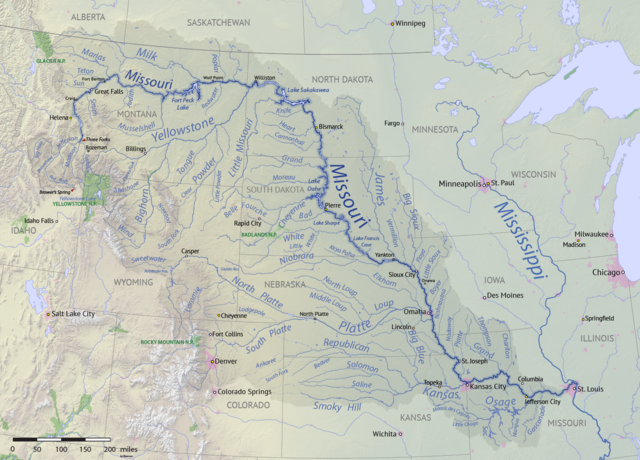
English: Map of the Missouri River drainage basin in the US and Canada. made using USGS and Natural Earth data. Replacement for File:Missouririvermap.jpg.
วันที่
แหล่งที่มา
งานของตัว
ผู้สร้างสรรค์
Shannon1
This file has an extracted image: File:North Dakota on Missouri River basin map (cropped).png.
This file is licensed under the Creative Commons Attribution-Share Alike 4.0 International, 3.0 Unported, 2.5 Generic, 2.0 Generic and 1.0 Generic license.
{{Information |description ={{en|1=Map of the Missouri River drainage basin in the US and Canada. made using USGS and Natural Earth data. Replacement for File:Missouririvermap.jpg.}} |source =Own work |author =Shannon1 |date =2018-03-21 }} Category:Missouri River
ไฟล, missouri, river, basin, ไฟล, ประว, ไฟล, หน, าท, ภาพน, การใช, ไฟล, วนกลาง, อม, ลเก, ยวก, บภาพขนาดของต, วอย, างน, กเซล, ความละเอ, ยดอ, กเซล, กเซล, กเซล, กเซล, กเซล, ภาพท, ความละเอ, ยดส, งกว, 8206, กเซล, ขนาดไฟล, เมกะไบต, ชน, ดไมม, image, ปภาพหร, อไฟล, เส, ย. ifl prawtiifl hnathimiphaphni karichiflswnklang khxmulekiywkbphaphkhnadkhxngtwxyangni 800 575 phikesl khwamlaexiydxun 320 230 phikesl 640 460 phikesl 1 024 736 phikesl 1 280 920 phikesl 1 496 1 075 phikesl duphaphthimikhwamlaexiydsungkwa 8206 1 496 1 075 phikesl khnadifl 2 63 emkaibt chnidimm image png rupphaphhruxiflesiyngni tnchbbxyuthi khxmmxns raylaexiyddanlang epnkhxkhwamthiaesdngphlcak ifltnchbbinkhxmmxns khxmmxnsepnewbistinokhrngkarsahrbekbrwbrwmsuxesri thi khunsamarthchwyid khwamyx khaxthibayMissouri River basin map png English Map of the Missouri River drainage basin in the US and Canada made using USGS and Natural Earth data Replacement for File Missouririvermap jpg wnthi 21 minakhm ph s 2561aehlngthima ngankhxngtwphusrangsrrkh Shannon1 This file has an extracted image File North Dakota on Missouri River basin map cropped png karxnuyatichsiththi khapheca inthanaphuthuxlikhsiththikhxngphaphhruxsuxni xnuyatihichphaphhruxsuxniphayitenguxnikhtxipni xnuyatihkhdlxk aeckcayaela hruxddaeprexksarniphayitenguxnikhkhxngsyyaxnuyatexksaresrikhxngknu run 1 2 hruxrunid nbcaknithixxkodymulnithisxftaewresri odyimmiswnidhamaekikh immikhxkhwampkhnaaelapkhlng saenakhxngsyyaxnuyatrwmxyuinswnchux syyaxnuyatexksaresrikhxngknuhttp www gnu org copyleft fdl html GFDL GNU Free Documentation License true trueThis file is licensed under the Creative Commons Attribution Share Alike 4 0 International 3 0 Unported 2 5 Generic 2 0 Generic and 1 0 Generic license khunsamarth thicaaebngpn thicathasaena aeckcay aelasngngandngklawtxip thicaeriyberiyngihm thicaddaeplngngandngklaw phayitenguxnikhtxipni aesdngthima khuntxngihekiyrtiecakhxngnganxyangehmaasm odyephimlingkipyngsyyaxnuyat aelarabuhakmikarepliynaeplng khunxacthaechnniidinrupaebbidkidtamkhwr aettxngimichinlksnathiaenawaphuihxnuyatsnbsnunkhunhruxkarichngankhxngkhun xnuyataebbediywkn hakkhunddaeplng epliynrup hruxtxetimnganni khuntxngichsyyaxnuyataebbediywknhruxaebbthiehmuxnkbsyyaxnuyatthiichkbnganniethannhttps creativecommons org licenses by sa 4 0 CC BY SA 4 0 Creative Commons Attribution Share Alike 4 0 true truekhunsamartheluxksyyaxnuyatdngklawtamtxngkarkhabrryayodyyxithyephimkhabrryaythrrthdediywephuxkhyaykhwamwaiflnimixairixethmthiaesdngxyuiniflniprakxbdwyphusrangbangkhathiimmiixethmwikisnethsyuxaraexl https commons wikimedia org wiki user Shannon1chuxphuichwikimiediy Shannon1chuxphusrangsrrkh Shannon1sthanalikhsiththimilikhsiththisyyaxnuyatCreative Commons Attribution ShareAlike 3 0 Unported xngkvsCreative Commons Attribution ShareAlike 4 0 International xngkvsCreative Commons Attribution ShareAlike 2 5 Generic xngkvsCreative Commons Attribution ShareAlike 1 0 Generic xngkvsGNU Free Documentation License version 1 2 or later xngkvsCreative Commons Attribution ShareAlike 2 0 Generic xngkvswnthisrang wnkxtng21 minakhm 2018thimakhxngiflkarsrangdngedimodyphuxpohld prawtiifl khlikwnthi ewlaephuxduiflthipraktinkhnann wnthi ewlarupyxkhnadphuichkhwamehn pccubn07 15 9 emsayn 25611 496 1 075 2 63 emkaibt Shannon1missing label 04 56 31 minakhm 25611 500 1 080 2 8 emkaibt Shannon1slight fixes 02 30 31 minakhm 25611 500 1 078 2 78 emkaibt Shannon1 Information description en 1 Map of the Missouri River drainage basin in the US and Canada made using USGS and Natural Earth data Replacement for File Missouririvermap jpg source Own work author Shannon1 date 2018 03 21 Category Missouri River hnathimiphaphni hnatxipni oyngmathiphaphni aemnamissuri karichiflswnklang wikixuntxipniichiflni karichbn af wikipedia org Missouririvier karichbn azb wikipedia org میزوری چایی karichbn az wiktionary org Missuri karichbn ba wikipedia org Missuri jylga karichbn be wikipedia org Misury raka karichbn bh wikipedia org म स र नद karichbn bn wikipedia org ম স র নদ karichbn ca wikipedia org Iowa Kansas City Missouri Kansas City Kansas Riu Platte karichbn cv wikipedia org Missuri yuhanshyv karichbn da wikipedia org Missouri floden karichbn en wikipedia org Missouri River Grand River South Dakota User Shannon1 Sandbox 5 User Shannon1 Maps Yellowstone expedition List of tributaries of the Missouri River Wikipedia Graphics Lab Map workshop Archive Jul 2011 List of dams in the Missouri River watershed User Shannon1 Maps to do Joseph LaBarge Spread Eagle steamboat Emilie steamboat karichbn es wikipedia org Iowa Dakota del Norte Dakota del Sur Denver Rio Misuri Bismarck Dakota del Norte Misuri Rio Yellowstone Lincoln Nebraska Omaha Nebraska Columbia Misuri Kansas City Misuri Topeka Rio Marias Sioux City Kansas City Kansas Rio Cheyenne Rio Gallatin Great Falls Montana Rio Platte Rio Milk Rio James Dakotas Rio Smoky Hill Rio Saline Kansas Rio Niobrara dukarichthwolkephimetimkhxngiflnikhxmulekiywkbphaph phaphnimikhxmulephimetim sungswnihymacakklxngdicitxlhruxsaeknenxrthisamarthekbkhxmuldngklawiwrwmkbphaphid thaphaphnithukprbprungaekikhhruxepliynaeplngcakedim khxmulbangxyangcayngkhngimepliynaeplngehmuxnphaphthithukprbprungaekikhnnsxftaewrthiichAdobe ImageReadykhwamlaexiydaenwnxn59 06 dpckhwamlaexiydaenwtng59 06 dpc ekhathungcak https th wikipedia org wiki ifl Missouri River basin map png, wikipedia, วิกิ หนังสือ, หนังสือ, ห้องสมุด,