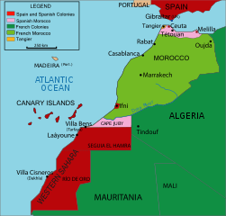
English: Vectorised map about the French and Spanish protectorate on Morocco in 1912 - own work inspired from Jean Sellier, Atlas des peuples d'Afrique, p. 84.
This bad Adobe SVG map is very large because its creator kept the superfluous Adobe PGF or other CDATA garbage
.
This SVG map contains embedded raster graphics.[1] Such images are liable to produce inferior results when scaled to different sizes (as well as possibly being very inefficient in file size). If appropriate to do so, they should be replaced with images created using vector graphics. Note: This template is only supposed to be used if the SVG file mixes vector and raster graphics. If the SVG file only contains raster graphics {{FakeSVG}} is supposed to be used. See also {{TopoSVG}}.
The file size of this SVG map may be irrationally large because its text has been converted to paths, to inhibit translation.
Reverted to version as of 13:49, 4 June 2008 (UTC) The legal international status of Cap Juby zone never changed during the Spanish ocupation (1912-1958).
{{Information |Description={{en|1=Vectorised map about thefrench and spanish protectorate on marocco In 1912 own work inspired from Jean Sellier, Atlas des peuples d'Afrique,p 84. Protectorat marocain Protectorado maroqui A PNG french version is availabl
ไฟล, morocco, protectorate, ไฟล, ประว, ไฟล, หน, าท, ภาพน, การใช, ไฟล, วนกลาง, อม, ลเก, ยวก, บภาพขนาดของต, วอย, าง, ของไฟล, กเซล, ความละเอ, ยดอ, กเซล, กเซล, กเซล, กเซล, กเซล, ภาพท, ความละเอ, ยดส, งกว, 8206, ไฟล, กเซล, ขนาดไฟล, โลไบต, ปภาพหร, อไฟล, เส, ยงน, นฉบ,. ifl prawtiifl hnathimiphaphni karichiflswnklang khxmulekiywkbphaphkhnadkhxngtwxyang PNG nikhxngifl SVG ni 406 388 phikesl khwamlaexiydxun 251 240 phikesl 502 480 phikesl 804 768 phikesl 1 072 1 024 phikesl 2 143 2 048 phikesl duphaphthimikhwamlaexiydsungkwa 8206 ifl SVG 406 388 phikesl khnadifl 815 kiolibt rupphaphhruxiflesiyngni tnchbbxyuthi khxmmxns raylaexiyddanlang epnkhxkhwamthiaesdngphlcak ifltnchbbinkhxmmxns khxmmxnsepnewbistinokhrngkarsahrbekbrwbrwmsuxesri thi khunsamarthchwyid khwamyx khaxthibayMorocco Protectorate svg English Vectorised map about the French and Spanish protectorate on Morocco in 1912 own work inspired from Jean Sellier Atlas des peuples d Afrique p 84 Francais Protectorat marocainEspanol Protectorado marroqui A PNG french version is availableaehlngthima Image Maroc sans cadre svgphusrangsrrkh Cradelkarxnuyat karichiflniihm khapheca inthanaphuthuxlikhsiththikhxngphaphhruxsuxni xnuyatihichphaphhruxsuxniphayitenguxnikhtxipni xnuyatihkhdlxk aeckcayaela hruxddaeprexksarniphayitenguxnikhkhxngsyyaxnuyatexksaresrikhxngknu run 1 2 hruxrunid nbcaknithixxkodymulnithisxftaewresri odyimmiswnidhamaekikh immikhxkhwampkhnaaelapkhlng saenakhxngsyyaxnuyatrwmxyuinswnchux syyaxnuyatexksaresrikhxngknuhttp www gnu org copyleft fdl html GFDL GNU Free Documentation License true trueiflnixyuphayitsyyaxnuyat khriexthifkhxmmxns aebbaesdngthima xnuyataebbediywkn 3 0 tnchbbkhunsamarth thicaaebngpn thicathasaena aeckcay aelasngngandngklawtxip thicaeriyberiyngihm thicaddaeplngngandngklaw phayitenguxnikhtxipni aesdngthima khuntxngihekiyrtiecakhxngnganxyangehmaasm odyephimlingkipyngsyyaxnuyat aelarabuhakmikarepliynaeplng khunxacthaechnniidinrupaebbidkidtamkhwr aettxngimichinlksnathiaenawaphuihxnuyatsnbsnunkhunhruxkarichngankhxngkhun xnuyataebbediywkn hakkhunddaeplng epliynrup hruxtxetimnganni khuntxngichsyyaxnuyataebbediywknhruxaebbthiehmuxnkbsyyaxnuyatthiichkbnganniethannpayaesdngsthanalikhsiththinithukephimephuxihepniptamkarepliynaeplngsyyaxnuyatkhxngmulnithiwikimiediy cak GFDL ipyng GFDL khwbkhukb CC BY SA 3 0 http creativecommons org licenses by sa 3 0 CC BY SA 3 0 Creative Commons Attribution Share Alike 3 0 true trueiflnixyuphayitsyyaxnuyatkhriexthifkhxmmxns runaesdngthima xnuyataebbediywkn 2 5 thwip 2 0 thwip aela 1 0 thwipkhunsamarth thicaaebngpn thicathasaena aeckcay aelasngngandngklawtxip thicaeriyberiyngihm thicaddaeplngngandngklaw phayitenguxnikhtxipni aesdngthima khuntxngihekiyrtiecakhxngnganxyangehmaasm odyephimlingkipyngsyyaxnuyat aelarabuhakmikarepliynaeplng khunxacthaechnniidinrupaebbidkidtamkhwr aettxngimichinlksnathiaenawaphuihxnuyatsnbsnunkhunhruxkarichngankhxngkhun xnuyataebbediywkn hakkhunddaeplng epliynrup hruxtxetimnganni khuntxngichsyyaxnuyataebbediywknhruxaebbthiehmuxnkbsyyaxnuyatthiichkbnganniethannhttps creativecommons org licenses by sa 2 5 CC BY SA 2 5 Creative Commons Attribution Share Alike 2 5 true truekhunsamartheluxksyyaxnuyatdngklawtamtxngkarewxrchnxun French SVG German svg Arabic svg magyar Lithuanian svgSVG genesisInfoField sxrsokhdkhxngifl SVG niimthuktxng enuxngcakphbkhxphidphlad238 aehng iflphaphkrafiksewketxr W3C trwcsxbaelwmikhxphidphladiniflni srangkhunodyich Adobe Illustrator aelaody Inkscape This bad Adobe SVG map is very large because its creator kept the superfluous Adobe PGF or other CDATA garbage This SVG map contains embedded raster graphics 1 Such images are liable to produce inferior results when scaled to different sizes as well as possibly being very inefficient in file size If appropriate to do so they should be replaced with images created using vector graphics Note This template is only supposed to be used if the SVG file mixes vector and raster graphics If the SVG file only contains raster graphics FakeSVG is supposed to be used See also TopoSVG The file size of this SVG map may be irrationally large because its text has been converted to paths to inhibit translation khabrryayodyyxithyephimkhabrryaythrrthdediywephuxkhyaykhwamwaiflnimixairixethmthiaesdngxyuiniflniprakxbdwysthanalikhsiththimilikhsiththisyyaxnuyatCreative Commons Attribution ShareAlike 2 5 Generic xngkvsCreative Commons Attribution ShareAlike 2 0 Generic xngkvsCreative Commons Attribution ShareAlike 1 0 Generic xngkvsCreative Commons Attribution ShareAlike 3 0 Unported xngkvsGNU Free Documentation License version 1 2 or later xngkvs prawtiifl khlikwnthi ewlaephuxduiflthipraktinkhnann wnthi ewlarupyxkhnadphuichkhwamehn pccubn02 25 17 phvscikayn 2563406 388 815 kiolibt FertejolReverted to version as of 13 49 4 June 2008 UTC The legal international status of Cap Juby zone never changed during the Spanish ocupation 1912 1958 07 05 28 minakhm 2553406 388 827 kiolibt FladPosition adjustment 06 51 28 minakhm 2553406 388 828 kiolibt FladTransform some text in order to show properly 06 49 28 minakhm 2553406 388 825 kiolibt FladTransform some text in order to show properly 06 46 28 minakhm 2553406 388 825 kiolibt FladCap Juby was considered as a part of the spanish colonies Transform some text to show properly 20 49 4 mithunayn 2551406 388 815 kiolibt Cradelmore translating Category Images by Cradel 02 38 2 mithunayn 2551406 388 817 kiolibt CradelCape Juby 16 01 1 mithunayn 2551406 388 821 kiolibt Cradel Information Description en 1 Vectorised map about thefrench and spanish protectorate on marocco In 1912 own work inspired from Jean Sellier Atlas des peuples d 039 Afrique p 84 Protectorat marocain Protectorado maroqui A PNG french version is availabl hnathimiphaphni hnatxipni oyngmathiphaphni ewsethirnsahara karichiflswnklang wikixuntxipniichiflni karichbn ary wikipedia org لحماية لفرانساوية على لمغريب لحماية الصبليونية على لمغريب karichbn ast wikipedia org Protectorau frances de Marruecos Africa Occidental Espanola karichbn azb wikipedia org ایسپانیا صحراسی karichbn bar wikipedia org Westsahara karichbn be wikipedia org Zahop Maroka Francyyaj karichbn bg wikipedia org Frensko Maroko karichbn ca wikipedia org Ifni Africa Occidental Espanyola Cap Juby Protectorat frances del Marroc karichbn cs wikipedia org Ifni Spanelska zapadni Afrika Cabo Juby Sakia al Hamra Rio de Oro Spanelska Sahara karichbn da wikipedia org Spansk Sahara Rio de Oro Fransk Marokko karichbn en wikipedia org Western Sahara Ifni Cape Juby Spanish Sahara Spanish protectorate in Morocco Ifni War Spanish West Africa Rio de Oro Saguia el Hamra Portal Western Sahara Morocco in World War II Wikipedia Graphics Lab Map workshop Archive Aug 2021 karichbn eo wikipedia org Hispana Maroko Orrivero Franca protektorato de Maroko karichbn eu wikipedia org Ifni Marokoko Protektoratu Frantsesa karichbn fa wikipedia org وادی الذهب ایفنی karichbn fi wikipedia org Ifni Ranskan Marokko Espanjan Lansi Afrikka karichbn hr wikipedia org Feski sporazum karichbn id wikipedia org Maroko Prancis Ifni karichbn io wikipedia org Ifni karichbn it wikipedia org Guerra di Ifni karichbn ja wikipedia org イフニ リヒャルト クーデンホーフ カレルギー dukarichthwolkephimetimkhxngiflnikhxmulekiywkbphaph phaphnimikhxmulephimetim sungswnihymacakklxngdicitxlhruxsaeknenxrthisamarthekbkhxmuldngklawiwrwmkbphaphid thaphaphnithukprbprungaekikhhruxepliynaeplngcakedim khxmulbangxyangcayngkhngimepliynaeplngehmuxnphaphthithukprbprungaekikhnnkhwamkwang405 833khwamsung387 866 ekhathungcak https th wikipedia org wiki ifl Morocco Protectorate svg, wikipedia, วิกิ หนังสือ, หนังสือ, ห้องสมุด,