2011-08-23T10:26:48Z Heb 680x520 (604212 Bytes) Added [[:en:Bornholm]] (taken from [[:File:Denmark blank map.svg]])
2011-04-12T00:40:40Z Alphathon 680x520 (602549 Bytes) Upgraded Sicily based on "File:Freeworldmaps-sicily.jpg". Upgraded Malta based on "File:Map of Malta 2.png". Simplified Croatian borders.
2011-04-10T21:43:04Z Alphathon 680x520 (607359 Bytes) Upgraded Croatia, Bosnia & Herzegovina, Slovenia and surrounding countries based on data from "File:Kroatien - Politische Gliederung (Karte).png"
2011-04-10T20:05:09Z Alphathon 680x520 (568373 Bytes) Improved Serbia, Montenegro and surrounding countries using data from "File:Serbia Map.png". Fixed Serbia-Montenegro border. Added Kosovo (using dashed border, since it is not a universally recognised nation, and left the lan
2011-04-10T15:55:02Z Alphathon 680x520 (524980 Bytes) Tweaked Ukraine and surrounding countries based on data from "File:Up-map.png"
2011-04-10T04:02:09Z Alphathon 680x520 (511168 Bytes) Improved Greece, Albania, F.Y.R. Macedonia and Bulgaria based on "File:Greece topo.jpg"
2011-04-10T02:48:52Z Alphathon 680x520 (505569 Bytes) Tweaked Germany and surrounding countries based on info from "File:Germany_general_map.png"
2011-04-10T01:54:05Z Alphathon 680x520 (493733 Bytes) Converted all lakes back to separate layer. Added Finish lakes and tweaked Finland shape based on "File:Finland 1996 CIA map.jpg". Added Swiss lakes based on "File:Suisse cantons.svg". Tweaked Scotland and added Lochs.
2011-04-10T00:07:54Z Alphathon 680x520 (450120 Bytes) Improved England outline and added Isle of Wight based on "File:England Regions - Blank.svg". Improved Denmark based on "File:2 digit postcode danmark.png". Improved Sweden based on "File:Map of Sweden, CIA, 1996.jpg"
2011-04-08T15:53:07Z Alphathon 680x520 (438878 Bytes) Upgraded/fixed various parts of the map. Details: *Some minor fixes to Ireland and added some of the larger lakes based on [[:File:Ireland_trad_counties_named.svg]] *Pretty major fixes to Scotland (mainly the west coast and i
2008-09-17T09:50:25Z F7 680x520 (531491 Bytes)
2008-09-17T09:42:57Z F7 680x520 (2353 Bytes)
2008-05-26T19:04:07Z Collard 680x520 (531491 Bytes) uploading on behalf of [[User:Checkit]], direct complaints to him plox: 'Moved countries out of the "outlines" group, removed "outlines" style class, remove separate style information for Russia'
2008-04-30T01:38:52Z TimothyBourke 680x520 (531767 Bytes) Changed the country code of Serbia to RS per [http://en.wikipedia.org/wiki/Serbian_country_codes] and the file [http://www.iso.org/iso/iso3166_en_code_lists.txt].
2007-07-10T11:47:59Z MrWeeble 680x520 (533112 Bytes) Updated to include British Crown Dependencies as seperate entities and regroup them as "British Islands", with some simplifications to the XML and CSS
2007-05-14T17:17:34Z Zirland 680x520 (540659 Bytes) serbia and montenegro
2007-03-30T20:40:49Z W!B: 680x520 (538830 Bytes) minor corr: update nl:Ijsselmeer, del fi:lakes (all small), add ru:lake Oneka (all ref maps.google), glued northern irland back to ie ;)
2007-02-04T15:07:29Z Maix 680x520 (538310 Bytes) {{Information |Description=A blank Map of Europe in SVG format. Every country has an id which is its ISO-3116-1-ALPHA2 code in lower case for easy coloring. |Source=Image based on [[Image:Europe_countries.svg|]] by [[User:Ti
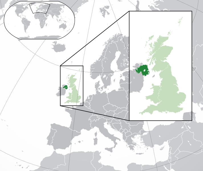
== {{int:filedesc}} == {{Information |Description={{en|A map of Northern Ireland (dark green) within the United Kingdom (dark and light green) and Europe (dark green, light green and darker grey).}} |Source={{Derived from|Blank_map_of_Europe.svg|displa...
ไฟล, northern, ireland, europe, ไฟล, ประว, ไฟล, หน, าท, ภาพน, การใช, ไฟล, วนกลาง, อม, ลเก, ยวก, บภาพขนาดของต, วอย, าง, ของไฟล, กเซล, ความละเอ, ยดอ, กเซล, กเซล, กเซล, กเซล, กเซล, กเซล, ภาพท, ความละเอ, ยดส, งกว, 8206, ไฟล, กเซล, ขนาดไฟล, เมกะไบต, ปภาพหร, อไฟล, เ. ifl prawtiifl hnathimiphaphni karichiflswnklang khxmulekiywkbphaphkhnadkhxngtwxyang PNG nikhxngifl SVG ni 713 600 phikesl khwamlaexiydxun 285 240 phikesl 571 480 phikesl 913 768 phikesl 1 218 1 024 phikesl 2 435 2 048 phikesl 2 045 1 720 phikesl duphaphthimikhwamlaexiydsungkwa 8206 ifl SVG 2 045 1 720 phikesl khnadifl 7 84 emkaibt rupphaphhruxiflesiyngni tnchbbxyuthi khxmmxns raylaexiyddanlang epnkhxkhwamthiaesdngphlcak ifltnchbbinkhxmmxns khxmmxnsepnewbistinokhrngkarsahrbekbrwbrwmsuxesri thi khunsamarthchwyid khwamyx khaxthibayNorthern Ireland in the UK and Europe svg English A map of Northern Ireland within the United Kingdom and Europe The map is a polar orthographic projection Northern Ireland Great Britain United Kingdom except Northern Ireland Europe except UK Francais Une carte de l Irlande du Nord au sein du Royaume Uni et en Europe La carte est un polair projection orthographique Irlande du Nord Grande Bretagne Royaume Unie sauf l Irlande du Nord Europe sauf le Royaume Unie Deutsch Eine Karte der Nordirland drinnen das Vereinigtes Konigreich und drinnen Europa Die Karte ist ein polare orthografische Azimutalprojektion Nordirland Grossbritannien Vereinigtes Konigreich ausser Nordirland Europa ausser das Vereinigtes Konigreich Cymraeg Gogledd Iwerddon Y Deyrnas Unedig Ewrop Gaidhlig Eirinn a Tuath An Rioghachd Aonaichte An Roinn Eorpa Gaeilge Tuaisceart Eireann An Riocht Aontaithe An Eoraipwnthi 25 kumphaphnth ph s 2555 22 33 UTC aehlngthima This file was derived from Blank map of Europe with disputed regions svg phusrangsrrkh Blank map of Europe with disputed regions svg maix nganddaeplng Alphathon aeɫfe 8ɒn ewxrchnxun English EnglandKernowek Pow SowsGaidhlig SasainnGaeilge SasanaCymraeg LloegrDeutsch England English ScotlandGaidhlig AlbaGaeilge AlbainCymraeg Yr AlbanDeutsch SchottlandFrancais Ecosse English WalesCymraeg CymruGaidhlig A ChuimrighGaeilge An Bhreatain BheagKernowek KembraDeutsch WalesSVG genesisInfoField sxrsokhdkhxngifl SVG khnadihyniimthuktxng enuxngcakphbkhxphidphlad201 aehng iflphaphkrafiksewketxr W3C trwcsxbaelwmikhxphidphladiniflthimikhnadihymakni srangkhunodyich Inkscape or with something else karxnuyatichsiththi iflnixyuphayitsyyaxnuyat khriexthifkhxmmxns aebbaesdngthima xnuyataebbediywkn 3 0 tnchbbkhunsamarth thicaaebngpn thicathasaena aeckcay aelasngngandngklawtxip thicaeriyberiyngihm thicaddaeplngngandngklaw phayitenguxnikhtxipni aesdngthima khuntxngihekiyrtiecakhxngnganxyangehmaasm odyephimlingkipyngsyyaxnuyat aelarabuhakmikarepliynaeplng khunxacthaechnniidinrupaebbidkidtamkhwr aettxngimichinlksnathiaenawaphuihxnuyatsnbsnunkhunhruxkarichngankhxngkhun xnuyataebbediywkn hakkhunddaeplng epliynrup hruxtxetimnganni khuntxngichsyyaxnuyataebbediywknhruxaebbthiehmuxnkbsyyaxnuyatthiichkbnganniethannhttps creativecommons org licenses by sa 3 0 CC BY SA 3 0 Creative Commons Attribution Share Alike 3 0 true true bnthukkarxphohld This image is a derivative work of the following images File Blank map of Europe svg licensed with Cc by sa 2 5 2012 02 21T16 27 27Z Alphathon 680x520 614699 Bytes Updated Metadata and the boarders coastlines along the western coast of the Black Sea 2011 09 19T22 57 58Z Alphathon 680x520 603759 Bytes Added North Northern Cyprus 2011 08 23T10 26 48Z Heb 680x520 604212 Bytes Added en Bornholm taken from File Denmark blank map svg 2011 04 12T00 40 40Z Alphathon 680x520 602549 Bytes Upgraded Sicily based on File Freeworldmaps sicily jpg Upgraded Malta based on File Map of Malta 2 png Simplified Croatian borders 2011 04 10T21 43 04Z Alphathon 680x520 607359 Bytes Upgraded Croatia Bosnia amp Herzegovina Slovenia and surrounding countries based on data from File Kroatien Politische Gliederung Karte png 2011 04 10T20 05 09Z Alphathon 680x520 568373 Bytes Improved Serbia Montenegro and surrounding countries using data from File Serbia Map png Fixed Serbia Montenegro border Added Kosovo using dashed border since it is not a universally recognised nation and left the lan 2011 04 10T15 55 02Z Alphathon 680x520 524980 Bytes Tweaked Ukraine and surrounding countries based on data from File Up map png 2011 04 10T04 02 09Z Alphathon 680x520 511168 Bytes Improved Greece Albania F Y R Macedonia and Bulgaria based on File Greece topo jpg 2011 04 10T02 48 52Z Alphathon 680x520 505569 Bytes Tweaked Germany and surrounding countries based on info from File Germany general map png 2011 04 10T01 54 05Z Alphathon 680x520 493733 Bytes Converted all lakes back to separate layer Added Finish lakes and tweaked Finland shape based on File Finland 1996 CIA map jpg Added Swiss lakes based on File Suisse cantons svg Tweaked Scotland and added Lochs 2011 04 10T00 07 54Z Alphathon 680x520 450120 Bytes Improved England outline and added Isle of Wight based on File England Regions Blank svg Improved Denmark based on File 2 digit postcode danmark png Improved Sweden based on File Map of Sweden CIA 1996 jpg 2011 04 08T15 53 07Z Alphathon 680x520 438878 Bytes Upgraded fixed various parts of the map Details Some minor fixes to Ireland and added some of the larger lakes based on File Ireland trad counties named svg Pretty major fixes to Scotland mainly the west coast and i 2008 09 17T09 50 25Z F7 680x520 531491 Bytes 2008 09 17T09 42 57Z F7 680x520 2353 Bytes 2008 05 26T19 04 07Z Collard 680x520 531491 Bytes uploading on behalf of User Checkit direct complaints to him plox Moved countries out of the outlines group removed outlines style class remove separate style information for Russia 2008 04 30T01 38 52Z TimothyBourke 680x520 531767 Bytes Changed the country code of Serbia to RS per http en wikipedia org wiki Serbian country codes and the file http www iso org iso iso3166 en code lists txt 2008 02 08T22 44 37Z CarolSpears 680x520 531767 Bytes validated 2007 07 10T11 47 59Z MrWeeble 680x520 533112 Bytes Updated to include British Crown Dependencies as seperate entities and regroup them as British Islands with some simplifications to the XML and CSS 2007 05 14T17 17 34Z Zirland 680x520 540659 Bytes serbia and montenegro 2007 03 30T20 40 49Z W B 680x520 538830 Bytes minor corr update nl Ijsselmeer del fi lakes all small add ru lake Oneka all ref maps google glued northern irland back to ie 2007 02 05T18 44 32Z Maix 680x520 538295 Bytes cropped 2007 02 04T15 07 29Z Maix 680x520 538310 Bytes Information Description A blank Map of Europe in SVG format Every country has an id which is its ISO 3116 1 ALPHA2 code in lower case for easy coloring Source Image based on Image Europe countries svg by User TiUploaded with derivativeFXkhabrryayodyyxithyephimkhabrryaythrrthdediywephuxkhyaykhwamwaiflnimixairxngkvsMap of Northern IrelandixethmthiaesdngxyuiniflniprakxbdwynxrethirnixraelndsthanalikhsiththimilikhsiththisyyaxnuyatCreative Commons Attribution ShareAlike 3 0 Unported xngkvswnthisrang wnkxtng25 kumphaphnth 2012 prawtiifl khlikwnthi ewlaephuxduiflthipraktinkhnann wnthi ewlarupyxkhnadphuichkhwamehn pccubn03 00 7 singhakhm 25572 045 1 720 7 84 emkaibt Rob984Improved version More accurate coastline borders etc Added Gradient and Longitude and latitude lines Zoom insert centred on UK 21 57 21 kumphaphnth 2557680 520 2 48 emkaibt Rob984White background so that the edge of the map is clear Consistency with other European countries 039 maps also 01 24 20 mkrakhm 2556680 520 2 46 emkaibt AlphathonAdded Robinson projection to top left corner 06 38 27 kumphaphnth 2555680 520 941 kiolibt AlphathonFixed XML 06 34 27 kumphaphnth 2555680 520 941 kiolibt AlphathonMore detailed version of the British Isles 07 36 26 kumphaphnth 2555680 520 789 kiolibt AlphathonAdded missing parts of Belgium and the Netherlands 05 36 26 kumphaphnth 2555680 520 806 kiolibt Alphathon int filedesc Information Description en A map of Northern Ireland dark green within the United Kingdom dark and light green and Europe dark green light green and darker grey Source Derived from Blank map of Europe svg displa hnathimiphaphni hnatxipni oyngmathiphaphni ixraelndehnux karichiflswnklang wikixuntxipniichiflni karichbn af wikipedia org Noord Ierland karichbn af wiktionary org Noord Ierland karichbn am wikipedia org ስሜን አየርላንድ karichbn ang wikipedia org Norderne irland karichbn ar wikipedia org أيرلندا الشمالية بوابة أيرلندا الشمالية صورة مختارة بوابة أيرلندا الشمالية صورة مختارة أرشيف بوابة أيرلندا الشمالية صورة مختارة 1 حقوق المثليين في أيرلندا الشمالية karichbn arz wikipedia org ايرلاندا الشماليه karichbn az wikipedia org Simali Irlandiya Avropa olkelerinin siyahisi karichbn be tarask wikipedia org Paynochnaya Irlyandyya karichbn be wikipedia org Paynochnaya Irlandyya karichbn bg wikipedia org Severna Irlandiya karichbn bh wikipedia org उत तर आयरल ड karichbn bn wikipedia org উত তর আয রল য ন ড ইউর প র স র বভ ম র ষ ট র এব ন র ভরশ ল অঞ চলসম হ র ত ল ক karichbn bs wikipedia org Sjeverna Irska karichbn bxr wikipedia org Hojto Irland karichbn ca wikipedia org Irlanda del Nord karichbn cdo wikipedia org Bae k Ai i lang karichbn chy wikipedia org United Kingdom karichbn cs wikipedia org Severni Irsko karichbn diq wikipedia org Irlanday Zimey karichbn el wikipedia org Boreia Irlandia karichbn en wikipedia org Northern Ireland Category Northern Ireland History of the Jews in Ireland Northern Ireland Law Commission List of sovereign states and dependent territories in Europe Vehicle registration plates of Northern Ireland LGBT rights in Northern Ireland karichbn en wikinews org Category Northern Ireland karichbn eo wikipedia org Nord Irlando karichbn es wikipedia org Irlanda del Norte Portal Irlanda Portal Irlanda Norte karichbn et wikipedia org Pohja Iirimaa karichbn fa wikipedia org ایرلند شمالی تاریخ یهودیان در ایرلند karichbn fa wikivoyage org ایرلند شمالی karichbn fi wikipedia org Pohjois Irlanti karichbn fr wikipedia org Irlande du Nord karichbn fr wikinews org Categorie Irlande du Nord karichbn gag wikipedia org Poyraz Irlandiya gazetalari listasi karichbn ga wikipedia org Tuaisceart Eireann Plata Claruchain d fheithicli i dTuaisceart Eireann karichbn gl wikipedia org Irlanda do Norte karichbn gn wikipedia org Yvate Irilanda dukarichthwolkephimetimkhxngiflnikhxmulekiywkbphaph phaphnimikhxmulephimetim sungswnihymacakklxngdicitxlhruxsaeknenxrthisamarthekbkhxmuldngklawiwrwmkbphaphid thaphaphnithukprbprungaekikhhruxepliynaeplngcakedim khxmulbangxyangcayngkhngimepliynaeplngehmuxnphaphthithukprbprungaekikhnnkhwamkwang2045khwamsung1720 ekhathungcak https th wikipedia org wiki ifl Northern Ireland in the UK and Europe svg, wikipedia, วิกิ หนังสือ, หนังสือ, ห้องสมุด,