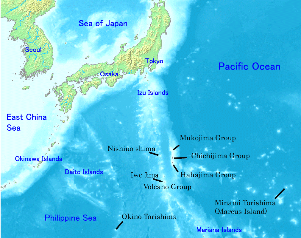
Created by [http://commons.wikimedia.org/wiki/Image:Map_of_ogasawara_islands.png Map of ogasawara islands.png] {{Information |Description=Map of Ogasawara Islands. |Source= |Date= |Author= |Permission={{demis-pd}} }}
ไฟล, ogasawara, islands, ไฟล, ประว, ไฟล, หน, าท, ภาพน, การใช, ไฟล, วนกลางขนาดของต, วอย, างน, กเซล, ความละเอ, ยดอ, กเซล, กเซล, กเซล, ภาพท, ความละเอ, ยดส, งกว, 8206, กเซล, ขนาดไฟล, โลไบต, ชน, ดไมม, image, ปภาพหร, อไฟล, เส, ยงน, นฉบ, บอย, คอมมอนส, รายละเอ, ยดด, า. ifl prawtiifl hnathimiphaphni karichiflswnklangkhnadkhxngtwxyangni 760 600 phikesl khwamlaexiydxun 304 240 phikesl 608 480 phikesl 1 011 798 phikesl duphaphthimikhwamlaexiydsungkwa 8206 1 011 798 phikesl khnadifl 296 kiolibt chnidimm image png rupphaphhruxiflesiyngni tnchbbxyuthi khxmmxns raylaexiyddanlang epnkhxkhwamthiaesdngphlcak ifltnchbbinkhxmmxns khxmmxnsepnewbistinokhrngkarsahrbekbrwbrwmsuxesri thi khunsamarthchwyid Map of Ogasawara Islands Created by Map of ogasawara islands png Public domain Public domain false false This image is in the public domain because it came from the site https www demis nl products web map server examples and was released by the copyright holder Permission is granted to copy distribute and or modify this map since it is based on free of copyright images from www demis nl See also approval email on de wp and its clarification Deutsch nbsp English nbsp makedonski nbsp മലയ ള nbsp Nederlands nbsp slovenscina nbsp Public domain Public domain false false This work has been released into the public domain by its copyright holder www demis nl This applies worldwide inbangpraeths karkrathadngklawxacimsamarththaidtamkdhmaywww demis nl xnuyatihthukkhnmisiththiinkarichiflniinthukehtuphlkarich odyimmimienguxnikh ewnaetkdhmayimxnuyatihthaechnnn Public domain Public domain false falsekhabrryayodyyxithyephimkhabrryaythrrthdediywephuxkhyaykhwamwaiflnimixairixethmthiaesdngxyuiniflniprakxbdwysthanalikhsiththicopyrighted dedicated to the public domain by copyright holder nbsp xngkvssyyaxnuyatreleased into the public domain by the copyright holder nbsp xngkvs prawtiifl khlikwnthi ewlaephuxduiflthipraktinkhnann wnthi ewlarupyxkhnadphuichkhwamehn pccubn05 01 1 mkrakhm 25511 011 798 296 kiolibt SagredoCreated by http commons wikimedia org wiki Image Map of ogasawara islands png Map of ogasawara islands png Information Description Map of Ogasawara Islands Source Date Author Permission demis pd 12 29 30 emsayn 25491 011 798 260 kiolibt Tdk commonswikiMap of Ogasawara Islands Created by Image Map of ogasawara islands png demis pd hnathimiphaphni hnatxipni oyngmathiphaphni phasaxngkvsaebbobnin hmuekaanmop otekiyw karichiflswnklang wikixuntxipniichiflni karichbn ar wikipedia org جزر بونين karichbn ast wikipedia org Islles Ogasawara Islles Nanpō karichbn az wikipedia org Bonin adalari Minamitori Okinotori Oqasavara adalari karichbn ca wikipedia org Illes Ogasawara Grup Ogasawara karichbn cs wikipedia org Boninske ostrovy karichbn cy wikipedia org Ynysoedd Bonin karichbn en wikipedia org Geography of Japan Tokyo List of islands of Japan Bonin Islands Ogasawara Tokyo Japanese archipelago Nanpō Islands Portal Japan Bonin white eye Wikipedia Graphics Lab Images to improve Archive Jan 2008 Ogasawara Subprefecture Wandering Island List of governors of the Nanpō Islands Geography of the Bonin Islands karichbn eo wikipedia org Ogasavaroj karichbn es wikipedia org Tokio Islas Ogasawara Islas Nanpō karichbn eu wikipedia org Ogasawara uharteak karichbn fa wikipedia org ایوو جیما جزایر توکیو جزایر اوگاساوارا جزایر نانپو زیر استان اوگاساوارا karichbn fi wikipedia org Ogasawarasaaret karichbn fr wikipedia org Archipel Nanpō Archipel Ogasawara karichbn gl wikipedia org Minami Torishima Arquipelago xapones Illas Ogasawara karichbn he wikipedia org איי בונין karichbn hr wikipedia org Boninsko otocje Otoci Nanpō karichbn hy wikipedia org Տոկիո Բոնին կղզիներ karichbn id wikipedia org Tokyo Kepulauan Bonin Kepulauan Nanpō karichbn ilo wikipedia org Is isla ti Nanpō dukarichthwolkephimetimkhxngiflni ekhathungcak https th wikipedia org wiki ifl Ogasawara islands png, wikipedia, วิกิ หนังสือ, หนังสือ, ห้องสมุด,