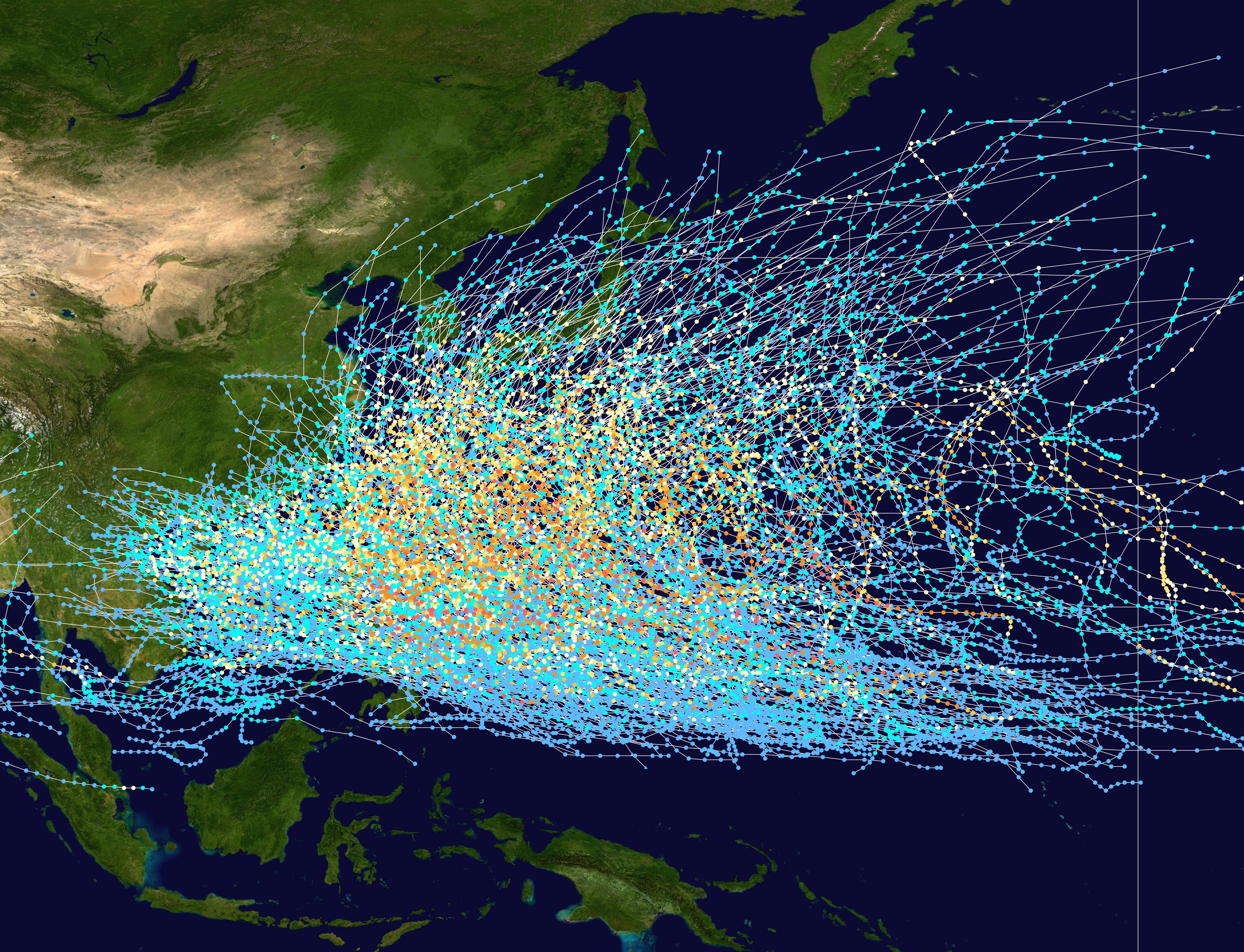
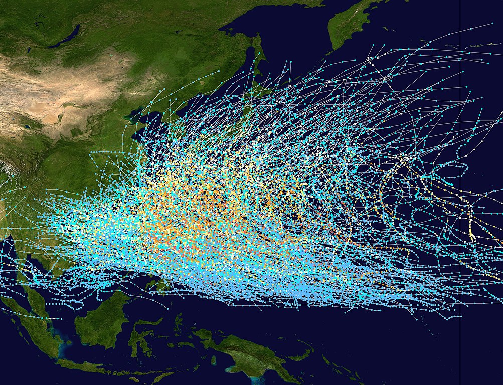
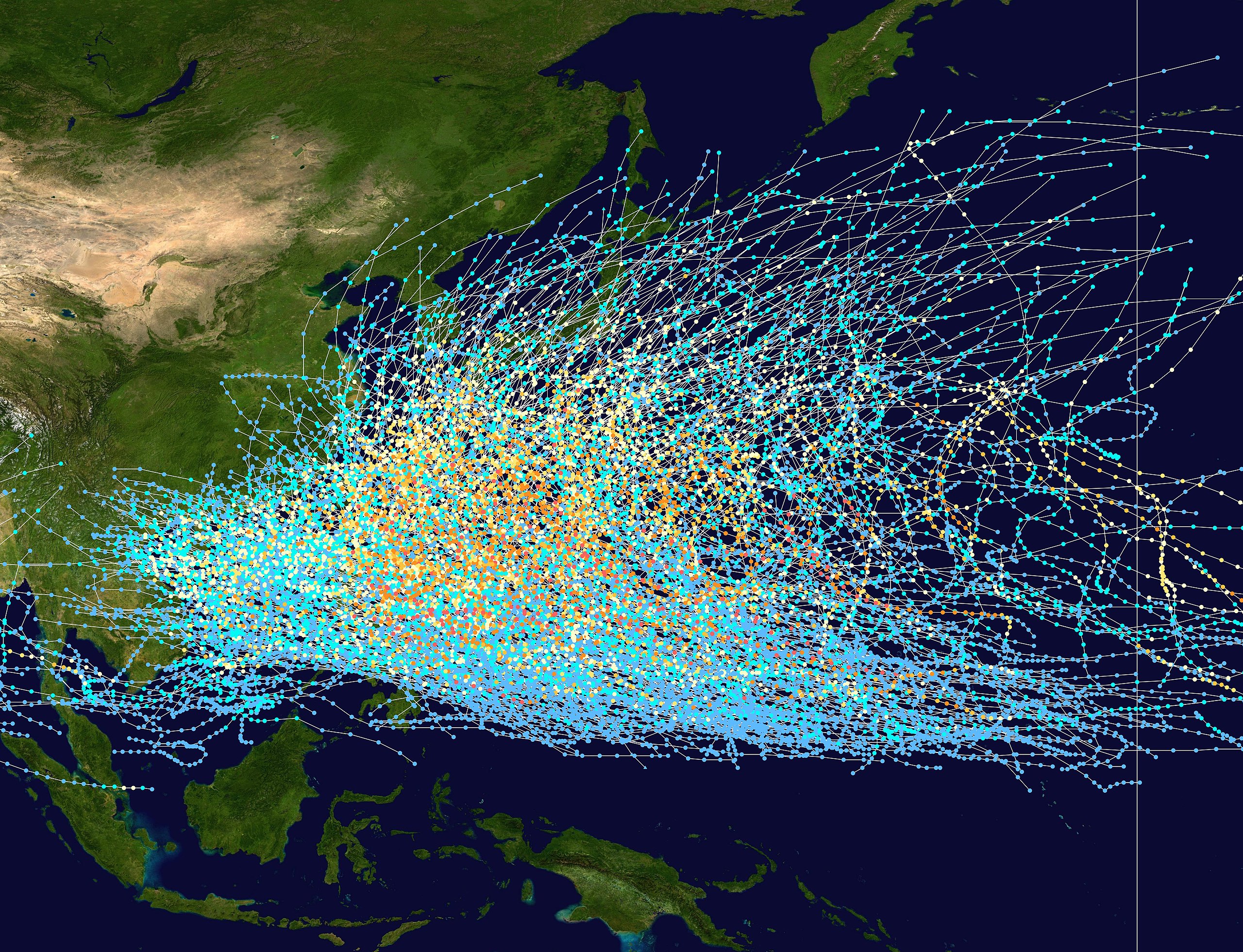
English: This trackmap shows the tracks of all tropical cyclones in the Northwest Pacific Ocean from 1980 to 2005. The International Date Line is marked on the map, this is the eastern boundary of the basin.. The points show the location of each storm at 6-hour intervals. The colour represents the storm's maximum sustained wind speeds as classified in the Saffir-Simpson Hurricane Scale (see below), and the shape of the data points represent the nature of the storm.
Created using WikiProject Tropical cyclones/Tracks. The background image is from NASA [1]. The tracking data is from the Joint Typhoon Warning Center's best track database
ไฟล, pacific, typhoon, tracks, 1980, 2005, ไฟล, ประว, ไฟล, หน, าท, ภาพน, การใช, ไฟล, วนกลาง, อม, ลเก, ยวก, บภาพขนาดของต, วอย, างน, กเซล, ความละเอ, ยดอ, กเซล, กเซล, กเซล, กเซล, กเซล, กเซล, ภาพท, ความละเอ, ยดส, งกว, 8206, กเซล, ขนาดไฟล, เมกะไบต, ชน, ดไมม, image,. ifl prawtiifl hnathimiphaphni karichiflswnklang khxmulekiywkbphaphkhnadkhxngtwxyangni 783 600 phikesl khwamlaexiydxun 313 240 phikesl 627 480 phikesl 1 003 768 phikesl 1 280 980 phikesl 2 560 1 961 phikesl 4 700 3 600 phikesl duphaphthimikhwamlaexiydsungkwa 8206 4 700 3 600 phikesl khnadifl 4 04 emkaibt chnidimm image jpeg rupphaphhruxiflesiyngni tnchbbxyuthi khxmmxns raylaexiyddanlang epnkhxkhwamthiaesdngphlcak ifltnchbbinkhxmmxns khxmmxnsepnewbistinokhrngkarsahrbekbrwbrwmsuxesri thi khunsamarthchwyid khaxthibayPacific typhoon tracks 1980 2005 jpg English This trackmap shows the tracks of all tropical cyclones in the Northwest Pacific Ocean from 1980 to 2005 The International Date Line is marked on the map this is the eastern boundary of the basin The points show the location of each storm at 6 hour intervals The colour represents the storm s maximum sustained wind speeds as classified in the Saffir Simpson Hurricane Scale see below and the shape of the data points represent the nature of the storm Saffir Simpson scale Tropical depression 38 mph 62 km h Tropical storm 39 73 mph 63 118 km h Category 1 74 95 mph 119 153 km h Category 2 96 110 mph 154 177 km h Category 3 111 129 mph 178 208 km h Category 4 130 156 mph 209 251 km h Category 5 157 mph 252 km h Unknown Storm type Tropical cyclone Subtropical cyclone Extratropical cyclone Remnant low Tropical disturbance Monsoon depressionwnthi 1980 2005aehlngthima Created using WikiProject Tropical cyclones Tracks The background image is from NASA 1 The tracking data is from the Joint Typhoon Warning Center s best track databasephusrangsrrkh Nilfanion Licensing Public domain Public domain false falsenganniidthukephyaephrsusatharnsmbtiodyecakhxng Nilfanion sungmiphlthwolkinbangpraeths karkrathadngklawxacimsamarththaidtamkdhmayNilfanion xnuyatihthukkhnmisiththiinkarichiflniinthukehtuphlkarich odyimmimienguxnikh ewnaetkdhmayimxnuyatihthaechnnnkhabrryayodyyxithyephimkhabrryaythrrthdediywephuxkhyaykhwamwaiflnimixairxngkvsTyphoon Tracks in the Western Pacificixethmthiaesdngxyuiniflniprakxbdwysthanalikhsiththicopyrighted dedicated to the public domain by copyright holder xngkvssyyaxnuyatreleased into the public domain by the copyright holder xngkvs prawtiifl khlikwnthi ewlaephuxduiflthipraktinkhnann wnthi ewlarupyxkhnadphuichkhwamehn pccubn04 21 28 kumphaphnth 25504 700 3 600 4 04 emkaibt Nilfanion Description align align right border 0 cellspacing 0 cellpadding 0 style background transparent text align center colspan 7 nowrap nowrap lt small gt Saffir Simpson Hurricane Scale lt small gt s hnathimiphaphni hnatxipni oyngmathiphaphni phayuitfunaepsifik aexngphayuhmunekhtrxn karichiflswnklang wikixuntxipniichiflni karichbn az wikipedia org Tayfun qasirgasi karichbn be tarask wikipedia org Tajfun karichbn be wikipedia org Tajfun karichbn en wikipedia org Kuroshio Current Pacific typhoon season Typhoon Tropical cyclone basins Wikipedia Reference desk Archives Science 2011 June 20 User AleahHahn Kuroshio Current karichbn fr wikipedia org Nomenclature des cyclones tropicaux Alerte cyclonique karichbn hak wikipedia org Thoi fung karichbn hy wikipedia org Խաղաղ օվկիանոս karichbn ja wikipedia org 台風 karichbn ka wikipedia org წყნარი ოკეანე ტაიფუნი ციკლონი karichbn kk wikipedia org Tynyk muhit Tajfun karichbn krc wikipedia org Shosh okean karichbn lez wikipedia org Las okean karichbn ms wikipedia org Taufan karichbn pt wikipedia org Bacia de formacao de ciclones tropicais Avisos e alertas de ciclone tropical karichbn ru wikipedia org Tihij okean Tajfun Bassejny tropicheskih ciklonov karichbn tl wikipedia org Tala ng panahon ng bagyo sa hilagang kanlurang Pasipiko karichbn tyv wikipedia org Oozhum okean karichbn uk wikipedia org Basejni tropichnih cikloniv Tajfun karichbn uz wikipedia org Tayfun karichbn vi wikipedia org Danh sach mua bao Tay Bắc Thai Binh Dương Bao nhiệt đới Tay Bắc Thai Binh Dương karichbn zh wikipedia org 颱風khxmulekiywkbphaph phaphnimikhxmulephimetim sungswnihymacakklxngdicitxlhruxsaeknenxrthisamarthekbkhxmuldngklawiwrwmkbphaphid thaphaphnithukprbprungaekikhhruxepliynaeplngcakedim khxmulbangxyangcayngkhngimepliynaeplngehmuxnphaphthithukprbprungaekikhnn error0 ekhathungcak https th wikipedia org wiki ifl Pacific typhoon tracks 1980 2005 jpg, wikipedia, วิกิ หนังสือ, หนังสือ, ห้องสมุด,