English: A diagram illustrating the layout of the Panama Canal (in quick JPEG format, auto-resizes to fit).
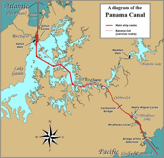
Due to the shape of the Isthmus of Panama, the Pacific end of the canal is actually the south-east end, and the Caribbean / Atlantic end is at the north-west. From the Pacific side, the Miraflores and Pedro Miguel locks (with two and one stages respectively) lead up to the highest level of the canal, 26 metres (85 feet) above sea level. The Culebra Cut (or Gaillard Cut) leads to Gatún Lake, created by damming the Chagres River; then the Gatún Locks lead back down to sea level in Limón Bay.
The heavy red line shows the ship route. The narrower red line in Gatún Lake is the Banana Cut, a shortcut used by canal boats and yachts.
วันที่
แหล่งที่มา
Source URL: Image:Panama_Canal_Rough_Diagram.png (GFDL file, reduced/retouched, saved JPEG format (5x faster than PNG), intended for use in frequently-read Wiki articles).
ผู้สร้างสรรค์
User:Johantheghost (JPEG version by Wikid77)
ภาพแผนที่การขนส่งนี้ ควรจะถูกสร้างใหม่เป็นกราฟิกส์เวกเตอร์ ซึ่งมีข้อดีอีกหลายประการ ดูเพิ่มเติมที่คอมมอนส์:สื่อต้องการเก็บกวาดสำหรับสารสนเทศเพิ่มเติม หากภาพนี้มีในรูปแบบกราฟิกส์เวกเตอร์อยู่แล้ว กรุณาอัปโหลดและแทนที่แม่แบบนี้ด้วย {{vector version available|ชื่อภาพใหม่}} แนะนำเป็นอย่างยิ่งให้ตั้งชื่อไฟล์เวกเตอร์ใหม่นั้นในรูปแบบ "Panama-Canal-rough-diagram-quick.svg" แล้วใส่แม่แบบ Vector version available (หรือ Vva) ซึ่งไม่ต้องใช้พารามิเตอร์ ชื่อภาพใหม่
This transport map image was uploaded in the JPEG format even though it consists of non-photographic data. This information could be stored more efficiently or accurately in the PNG or SVG format. If possible, please upload a PNG or SVG version of this image without compression artifacts, derived from a non-JPEG source (or with existing artifacts removed). After doing so, please tag the JPEG version with {{Superseded|NewImage.ext}} and remove this tag. This tag should not be applied to photographs or scans. For more information, see {{BadJPEG}}.
== Summary == A diagram illustrating the layout of the Panama Canal (in quick JPEG format, auto-resizes to fit). Due to the shape of the Isthmus of Panama, the Pacific
ไฟล, panama, canal, rough, diagram, quick, ไฟล, ประว, ไฟล, หน, าท, ภาพน, การใช, ไฟล, วนกลาง, อม, ลเก, ยวก, บภาพไม, ภาพท, รายละเอ, ยดส, งกว, าน, panama, canal, rough, diagram, quick, 8206, กเซล, ขนาดไฟล, โลไบต, ชน, ดไมม, image, jpeg, ปภาพหร, อไฟล, เส, ยงน, นฉบ,. ifl prawtiifl hnathimiphaphni karichiflswnklang khxmulekiywkbphaphimmiphaphthimiraylaexiydsungkwani Panama Canal rough diagram quick jpg 8206 560 540 phikesl khnadifl 57 kiolibt chnidimm image jpeg rupphaphhruxiflesiyngni tnchbbxyuthi khxmmxns raylaexiyddanlang epnkhxkhwamthiaesdngphlcak ifltnchbbinkhxmmxns khxmmxnsepnewbistinokhrngkarsahrbekbrwbrwmsuxesri thi khunsamarthchwyid khwamyx khaxthibayPanama Canal rough diagram quick jpg English A diagram illustrating the layout of the Panama Canal in quick JPEG format auto resizes to fit Due to the shape of the Isthmus of Panama the Pacific end of the canal is actually the south east end and the Caribbean Atlantic end is at the north west From the Pacific side the Miraflores and Pedro Miguel locks with two and one stages respectively lead up to the highest level of the canal 26 metres 85 feet above sea level The Culebra Cut or Gaillard Cut leads to Gatun Lake created by damming the Chagres River then the Gatun Locks lead back down to sea level in Limon Bay The heavy red line shows the ship route The narrower red line in Gatun Lake is the Banana Cut a shortcut used by canal boats and yachts wnthi 26 thnwakhm ph s 2549aehlngthima Source URL Image Panama Canal Rough Diagram png GFDL file reduced retouched saved JPEG format 5x faster than PNG intended for use in frequently read Wiki articles phusrangsrrkh User Johantheghost JPEG version by Wikid77 phaphaephnthikarkhnsngni khwrcathuksrangihmepnkrafiksewketxr sungmikhxdixikhlayprakar duephimetimthikhxmmxns suxtxngkarekbkwadsahrbsarsnethsephimetim hakphaphnimiinrupaebbkrafiksewketxrxyuaelw krunaxpohldaelaaethnthiaemaebbnidwy vector version available i chuxphaphihm i aenanaepnxyangyingihtngchuxiflewketxrihmnninrupaebb Panama Canal rough diagram quick svg aelwisaemaebb Vector version available hrux Vva sungimtxngichpharamietxr chuxphaphihmThis transport map image was uploaded in the JPEG format even though it consists of non photographic data This information could be stored more efficiently or accurately in the PNG or SVG format If possible please upload a PNG or SVG version of this image without compression artifacts derived from a non JPEG source or with existing artifacts removed After doing so please tag the JPEG version with Superseded NewImage ext and remove this tag This tag should not be applied to photographs or scans For more information see BadJPEG karxnuyatichsiththi xnuyatihkhdlxk aeckcayaela hruxddaeprexksarniphayitenguxnikhkhxngsyyaxnuyatexksaresrikhxngknu run 1 2 hruxrunid nbcaknithixxkodymulnithisxftaewresri odyimmiswnidhamaekikh immikhxkhwampkhnaaelapkhlng saenakhxngsyyaxnuyatrwmxyuinswnchux syyaxnuyatexksaresrikhxngknuhttp www gnu org copyleft fdl html GFDL GNU Free Documentation License true trueiflnixyuphayitsyyaxnuyat khriexthifkhxmmxns aebbaesdngthima xnuyataebbediywkn 3 0 tnchbbkhunsamarth thicaaebngpn thicathasaena aeckcay aelasngngandngklawtxip thicaeriyberiyngihm thicaddaeplngngandngklaw phayitenguxnikhtxipni aesdngthima khuntxngihekiyrtiecakhxngnganxyangehmaasm odyephimlingkipyngsyyaxnuyat aelarabuhakmikarepliynaeplng khunxacthaechnniidinrupaebbidkidtamkhwr aettxngimichinlksnathiaenawaphuihxnuyatsnbsnunkhunhruxkarichngankhxngkhun xnuyataebbediywkn hakkhunddaeplng epliynrup hruxtxetimnganni khuntxngichsyyaxnuyataebbediywknhruxaebbthiehmuxnkbsyyaxnuyatthiichkbnganniethannpayaesdngsthanalikhsiththinithukephimephuxihepniptamkarepliynaeplngsyyaxnuyatkhxngmulnithiwikimiediy cak GFDL ipyng GFDL khwbkhukb CC BY SA 3 0 http creativecommons org licenses by sa 3 0 CC BY SA 3 0 Creative Commons Attribution Share Alike 3 0 true truekhabrryayodyyxithyephimkhabrryaythrrthdediywephuxkhyaykhwamwaiflnimixairixethmthiaesdngxyuiniflniprakxbdwysthanalikhsiththimilikhsiththisyyaxnuyatCreative Commons Attribution ShareAlike 3 0 Unported xngkvsGNU Free Documentation License version 1 2 or later xngkvswnthisrang wnkxtng26 thnwakhm 2006 prawtiifl khlikwnthi ewlaephuxduiflthipraktinkhnann wnthi ewlarupyxkhnadphuichkhwamehn pccubn00 28 27 thnwakhm 2549560 540 57 kiolibt Wikid77 Summary A diagram illustrating the layout of the Panama Canal in quick JPEG format auto resizes to fit Due to the shape of the Isthmus of Panama the Pacific hnathimiphaphni hnatxipni oyngmathiphaphni khlxngpanama karichiflswnklang wikixuntxipniichiflni karichbn ar wikipedia org سكة حديد قناة بنما karichbn cdo wikipedia org Wikipedia Dŏng nieng gĭng dang 11 nguŏk 18 ho Wikipedia Dŏng nieng gĭng dang 11 nguŏk Panama Ong o karichbn cs wikipedia org Portal Stredni Amerika a Karibik Vodstvo Variace 2 karichbn de wikipedia org Rio Chagres karichbn en wikipedia org 1889 Operation Pelikan karichbn es wikipedia org Portal Panama Portal Panama Seleccionado Operacion Pelikan karichbn fi wikipedia org Operaatio Pelikaani Kayttaja Fiwiki tools bot kuvattomat 42 karichbn fr wikipedia org Operation Pelikan karichbn gor wikipedia org Templat Dulahe botiya to delomo sojara Agustus karichbn hu wikipedia org Panama csatorna karichbn id wikipedia org Templat Hari Ini Dalam Sejarah Agustus Wikipedia Arsip halaman utama 2019 08 15 Wikipedia Arsip halaman utama 2020 08 15 Wikipedia Arsip halaman utama 2021 08 15 Wikipedia Arsip halaman utama 2022 08 15 karichbn jv wikipedia org Cithakan DinaIkiIngSejarah 15 Agustus karichbn km wikipedia org ព រ កជ កប ណ ម karichbn li wikipedia org Panamaknaal karichbn map bms wikipedia org Cithakan Dina Kiye Nang Sejarah Agustus karichbn min wikipedia org Templat Hari Iko Dalam Sajarah Agustus karichbn mn wikipedia org Panamyn suvag karichbn simple wikipedia org Panama Canal karichbn ur wikipedia org مسودہ خانہ معلومات درکار تصاویر والے مضامین karichbn vi wikipedia org Kenh đao Panama karichbn www wikidata org Q7097382 karichbn zh wikinews org 蔡英文訪巴拿馬 與多國元首會談khxmulekiywkbphaph phaphnimikhxmulephimetim sungswnihymacakklxngdicitxlhruxsaeknenxrthisamarthekbkhxmuldngklawiwrwmkbphaphid thaphaphnithukprbprungaekikhhruxepliynaeplngcakedim khxmulbangxyangcayngkhngimepliynaeplngehmuxnphaphthithukprbprungaekikhnn error0 ekhathungcak https th wikipedia org wiki ifl Panama Canal rough diagram quick jpg, wikipedia, วิกิ หนังสือ, หนังสือ, ห้องสมุด,