คำอธิบายPanama canal panoramic view from the top of Ancon hill.jpg
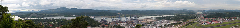
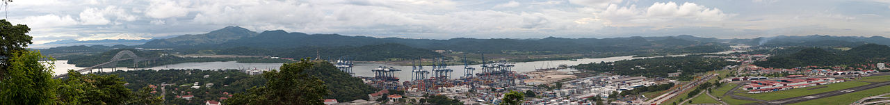
The other side of the hill - view of the canal and Bridge of the Americas connecting east to west and north to south! The Panama Canal is a ship canal which joins the Caribbean Sea to the Pacific ocean. One of the largest and most difficult engineering projects ever undertaken, it had an enormous impact on shipping between the two oceans, replacing the long and treacherous route via the Drake Passage and Cape Horn at the southernmost tip of South America. A ship sailing from New York to San Francisco via the canal travels 9,500 km (6,000 miles), well under half the 22,500 km (14,000 miles) route around Cape Horn.[1] Although the concept of a canal near Panama dates back to the early 16th century, the first attempt to construct a canal began in 1880 under French leadership. After this attempt failed and 21,900 workers died, the project of building a canal was attempted and completed by the United States in the early 1900s, with the canal opening in 1914. The building of the 77 km (48 mi) canal was plagued by problems, including disease (particularly malaria and yellow fever) and landslides. By the time the canal was completed, a total of 27,500 workmen are estimated to have died in the French and American efforts.
Since opening, the canal has been enormously successful, and continues to be a key conduit for international maritime trade. The canal can accommodate vessels from small private yachts up to large commercial vessels. The maximum size of vessel that can use the canal is known as Panamax; an increasing number of modern ships exceed this limit, and are known as post-Panamax or super-Panamax vessels. A typical passage through the canal by a cargo ship takes approximately 8–10 hours. In fiscal year 2008, 14,702 vessels passed through the waterway with a total 309.6 million Panama Canal/Universal Measurement System (PC/UMS) tons.
While the Pacific Ocean is west of the isthmus and the Atlantic to the east, the journey through the canal from the Pacific to the Atlantic is one from southeast to northwest. This is a result of the isthmus's "curving back on itself" in the region of the canal. The Bridge of the Americas at the Pacific end is about a third of a degree of longitude east of the end near Colon on the Atlantic.[2] An estimated 14,000 ships pass through the canal each year. Only 1,000 ships per year passed through the canal at its beginnings.
วันที่
Taken on 7 พฤศจิกายน พ.ศ. 2552, 19:05
แหล่งที่มา
Panama canal panoramic view from the top of Ancon hill
https://creativecommons.org/licenses/by/2.0CC BY 2.0 Creative Commons Attribution 2.0 truetrue
This image was originally posted to Flickr by brian.gratwicke at https://flickr.com/photos/19731486@N07/4084739236. It was reviewed on 4 ตุลาคม พ.ศ. 2560 by FlickreviewR and was confirmed to be licensed under the terms of the cc-by-2.0.
{{Information |Description=The other side of the hill - view of the canal and Bridge of the Americas connecting east to west and north to south! The Panama Canal is a ship canal which joins the Caribbean Sea to the Pacific ocean. One of the largest and mo
ไฟล, panama, canal, panoramic, view, from, ancon, hill, ไฟล, ประว, ไฟล, หน, าท, ภาพน, การใช, ไฟล, วนกลาง, อม, ลเก, ยวก, บภาพขนาดของต, วอย, างน, กเซล, ความละเอ, ยดอ, กเซล, กเซล, กเซล, กเซล, กเซล, ภาพท, ความละเอ, ยดส, งกว, 8206, กเซล, ขนาดไฟล, เมกะไบต, ชน, ดไมม,. ifl prawtiifl hnathimiphaphni karichiflswnklang khxmulekiywkbphaphkhnadkhxngtwxyangni 800 95 phikesl khwamlaexiydxun 320 38 phikesl 640 76 phikesl 1 024 121 phikesl 1 280 151 phikesl 10 557 1 248 phikesl duphaphthimikhwamlaexiydsungkwa 8206 10 557 1 248 phikesl khnadifl 5 15 emkaibt chnidimm image jpeg rupphaphhruxiflesiyngni tnchbbxyuthi khxmmxns raylaexiyddanlang epnkhxkhwamthiaesdngphlcak ifltnchbbinkhxmmxns khxmmxnsepnewbistinokhrngkarsahrbekbrwbrwmsuxesri thi khunsamarthchwyid khaxthibayPanama canal panoramic view from the top of Ancon hill jpg The other side of the hill view of the canal and Bridge of the Americas connecting east to west and north to south The Panama Canal is a ship canal which joins the Caribbean Sea to the Pacific ocean One of the largest and most difficult engineering projects ever undertaken it had an enormous impact on shipping between the two oceans replacing the long and treacherous route via the Drake Passage and Cape Horn at the southernmost tip of South America A ship sailing from New York to San Francisco via the canal travels 9 500 km 6 000 miles well under half the 22 500 km 14 000 miles route around Cape Horn 1 Although the concept of a canal near Panama dates back to the early 16th century the first attempt to construct a canal began in 1880 under French leadership After this attempt failed and 21 900 workers died the project of building a canal was attempted and completed by the United States in the early 1900s with the canal opening in 1914 The building of the 77 km 48 mi canal was plagued by problems including disease particularly malaria and yellow fever and landslides By the time the canal was completed a total of 27 500 workmen are estimated to have died in the French and American efforts Since opening the canal has been enormously successful and continues to be a key conduit for international maritime trade The canal can accommodate vessels from small private yachts up to large commercial vessels The maximum size of vessel that can use the canal is known as Panamax an increasing number of modern ships exceed this limit and are known as post Panamax or super Panamax vessels A typical passage through the canal by a cargo ship takes approximately 8 10 hours In fiscal year 2008 14 702 vessels passed through the waterway with a total 309 6 million Panama Canal Universal Measurement System PC UMS tons While the Pacific Ocean is west of the isthmus and the Atlantic to the east the journey through the canal from the Pacific to the Atlantic is one from southeast to northwest This is a result of the isthmus s curving back on itself in the region of the canal The Bridge of the Americas at the Pacific end is about a third of a degree of longitude east of the end near Colon on the Atlantic 2 An estimated 14 000 ships pass through the canal each year Only 1 000 ships per year passed through the canal at its beginnings wnthi Taken on 7 phvscikayn ph s 2552 19 05aehlngthima Panama canal panoramic view from the top of Ancon hillphusrangsrrkh Brian Gratwickeewxrchnxun iflxunthiichiflni Panama canal banner jpg taaehnngthitngklxng8 57 21 14 ehnux 79 34 10 86 tawntk phaphniaelaphaphxun n sthanthiediywknthi OpenStreetMap8 955873 79 569683karxnuyatichsiththi iflnixyuphayitsyyaxnuyatkhriexthifkhxmmxns run aesdngthima 2 0 thwipkhunsamarth thicaaebngpn thicathasaena aeckcay aelasngngandngklawtxip thicaeriyberiyngihm thicaddaeplngngandngklaw phayitenguxnikhtxipni aesdngthima khuntxngihekiyrtiecakhxngnganxyangehmaasm odyephimlingkipyngsyyaxnuyat aelarabuhakmikarepliynaeplng khunxacthaechnniidinrupaebbidkidtamkhwr aettxngimichinlksnathiaenawaphuihxnuyatsnbsnunkhunhruxkarichngankhxngkhunhttps creativecommons org licenses by 2 0 CC BY 2 0 Creative Commons Attribution 2 0 true true This image was originally posted to Flickr by brian gratwicke at https flickr com photos 19731486 N07 4084739236 It was reviewed on 4 tulakhm ph s 2560 by FlickreviewR and was confirmed to be licensed under the terms of the cc by 2 0 4 tulakhm ph s 2560khabrryayodyyxithyephimkhabrryaythrrthdediywephuxkhyaykhwamwaiflnimixairixethmthiaesdngxyuiniflniprakxbdwyphusrangbangkhathiimmiixethmwikisnethschuxphusrangsrrkh Brian GratwickeFlickr user ID xngkvs 19731486 N07yuxaraexl https www flickr com people 19731486 N07sthanalikhsiththimilikhsiththisyyaxnuyatCreative Commons Attribution 2 0 Generic xngkvscoordinates of the point of view xngkvs8 57 21 143 N 79 34 10 859 Wwnthisrang wnkxtng7 phvscikayn 2009thimakhxngiflfile available on the internet xngkvsxthibayin URL https www flickr com photos 19731486 N07 4084739236 phudaeninkar flikhekxr prawtiifl khlikwnthi ewlaephuxduiflthipraktinkhnann wnthi ewlarupyxkhnadphuichkhwamehn pccubn07 21 12 phvscikayn 255210 557 1 248 5 15 emkaibt Raeky Information Description The other side of the hill view of the canal and Bridge of the Americas connecting east to west and north to south The Panama Canal is a ship canal which joins the Caribbean Sea to the Pacific ocean One of the largest and mo hnathimiphaphni hnatxipni oyngmathiphaphni khlxngpanama karichiflswnklang wikixuntxipniichiflni karichbn as wikipedia org প ন ম খ ল karichbn bn wikipedia org প ন ম খ ল karichbn ca wikipedia org Historia ambiental karichbn ckb wikipedia org نۆکەندی پەنەما karichbn en wikipedia org Panama Canal karichbn es wikipedia org Canal de Panama karichbn eu wikipedia org Txikipedia Panamako kanala karichbn fa wikipedia org کانال پاناما karichbn fr wikipedia org Portail Panama Image au hasard karichbn gl wikipedia org Ponte das Americas Canle de Panama karichbn hak wikipedia org Panama Yun ho karichbn hy wikipedia org Պանամայի ջրանցք karichbn ja wikipedia org パナマ運河 karichbn ka wikipedia org პანამის არხი karichbn kk wikipedia org Panama kanaly karichbn kn wikipedia org ಪನ ಮ ಕ ಲ ವ karichbn mr wikipedia org पन म क लव karichbn pt wikipedia org Canal do Panama karichbn ta wikipedia org பன ம க ல வ ய karichbn uk wikipedia org Panamskij kanal karichbn zh wikipedia org 巴拿马运河khxmulekiywkbphaph phaphnimikhxmulephimetim sungswnihymacakklxngdicitxlhruxsaeknenxrthisamarthekbkhxmuldngklawiwrwmkbphaphid thaphaphnithukprbprungaekikhhruxepliynaeplngcakedim khxmulbangxyangcayngkhngimepliynaeplngehmuxnphaphthithukprbprungaekikhnnkarcdwangphaphpktikhwamlaexiydaenwnxn300 dpikhwamlaexiydaenwtng300 dpisxftaewrthiichAdobe Photoshop 7 0aekikhphaphlasud19 05 7 phvscikayn 2552sepssisRGB ekhathungcak https th wikipedia org wiki ifl Panama canal panoramic view from the top of Ancon hill jpg, wikipedia, วิกิ หนังสือ, หนังสือ, ห้องสมุด,