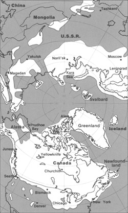
The maximum extent of glacial ice in the north polar area during Pleistocene time. {{PD-USGov-Interior-USGS}} http://pubs.usgs.gov/gip/continents/map.jpg
ไฟล, pleistocene, north, ไฟล, ประว, ไฟล, หน, าท, ภาพน, การใช, ไฟล, วนกลาง, อม, ลเก, ยวก, บภาพไม, ภาพท, รายละเอ, ยดส, งกว, าน, pleistocene, north, 8206, กเซล, ขนาดไฟล, โลไบต, ชน, ดไมม, image, jpeg, ปภาพหร, อไฟล, เส, ยงน, นฉบ, บอย, คอมมอนส, รายละเอ, ยดด, านล, าง. ifl prawtiifl hnathimiphaphni karichiflswnklang khxmulekiywkbphaphimmiphaphthimiraylaexiydsungkwani Pleistocene north ice map jpg 8206 250 417 phikesl khnadifl 38 kiolibt chnidimm image jpeg rupphaphhruxiflesiyngni tnchbbxyuthi khxmmxns raylaexiyddanlang epnkhxkhwamthiaesdngphlcak ifltnchbbinkhxmmxns khxmmxnsepnewbistinokhrngkarsahrbekbrwbrwmsuxesri thi khunsamarthchwyid The maximum extent of glacial ice in the north polar area during Pleistocene time Public domain Public domain false false This image is in the public domain in the United States because it only contains materials that originally came from the United States Geological Survey an agency of the United States Department of the Interior For more information see the official USGS copyright policy Bahasa Indonesia nbsp catala nbsp cestina nbsp Deutsch nbsp eesti nbsp English nbsp espanol nbsp francais nbsp galego nbsp italiano nbsp Nederlands nbsp portugues nbsp polski nbsp sicilianu nbsp suomi nbsp Tiếng Việt nbsp Turkce nbsp blgarski nbsp makedonski nbsp russkij nbsp മലയ ള nbsp 한국어 nbsp 日本語 nbsp 中文 nbsp 中文 简体 nbsp 中文 繁體 nbsp العربية nbsp فارسی nbsp http pubs usgs gov gip continents map jpg prawtiifl khlikwnthi ewlaephuxduiflthipraktinkhnann wnthi ewlarupyxkhnadphuichkhwamehn pccubn03 23 12 mithunayn 2548250 417 38 kiolibt SamuliliThe maximum extent of glacial ice in the north polar area during Pleistocene time PD USGov Interior USGS http pubs usgs gov gip continents map jpg hnathimiphaphni hnatxipni oyngmathiphaphni smyiphlsotsin karichiflswnklang wikixuntxipniichiflni karichbn bs wikipedia org Pleistocen karichbn ca wikipedia org Plistoce Mamut karichbn cs wikipedia org Pleistocen karichbn en wikipedia org Pleistocene Laurentide Ice Sheet User SEWilco Images Talk Geology of the United States Archive 1 karichbn en wikibooks org High School Earth Science Climate Change karichbn eo wikipedia org Glaciepoko karichbn es wikipedia org Pleistoceno Smilodon Mammuthus Teoria de los refugios pleistocenicos Parque estatal Watkins Glen karichbn eu wikipedia org Mamut karichbn fa wikipedia org یخسار لارنتی karichbn fi wikipedia org Laurentian mannerjaatikko karichbn fi wikibooks org Maapallo Luonnonilmiot ja luonnonmullistukset karichbn fr wikipedia org Inlandsis laurentidien karichbn hr wikipedia org Pleistocen karichbn hu wikipedia org Pleisztocen holocen becsapodasi esemeny karichbn id wikipedia org Zaman es Pleistosen karichbn it wikipedia org Pleistocene karichbn ja wikipedia org 更新世 五大湖 ノースダコタ州の地理 karichbn ka wikipedia org პლეისტოცენი karichbn lfn wikipedia org Plestosene karichbn ro wikipedia org Pleistocen karichbn ru wikipedia org Plejstocen Paleoindejcy Beringijskij volk Lavrentijskij lednikovyj shit karichbn sh wikipedia org Ledeno doba Pleistocen karichbn sl wikipedia org Pleistocen karichbn te wikipedia org ప ల స ట స న karichbn tr wikipedia org Pleistosen karichbn uk wikipedia org Plejstocen Lavrentijskij lodovikovij shit karichbn vi wikipedia org Kỳ băng ha Thế Pleistocen karichbn xmf wikipedia org პლეისტოცენი karichbn zh wikipedia org 更新世khxmulekiywkbphaph phaphnimikhxmulephimetim sungswnihymacakklxngdicitxlhruxsaeknenxrthisamarthekbkhxmuldngklawiwrwmkbphaphid thaphaphnithukprbprungaekikhhruxepliynaeplngcakedim khxmulbangxyangcayngkhngimepliynaeplngehmuxnphaphthithukprbprungaekikhnn error0 ekhathungcak https th wikipedia org wiki ifl Pleistocene north ice map jpg, wikipedia, วิกิ หนังสือ, หนังสือ, ห้องสมุด,