ภาพแผนที่เก่านี้ ควรจะถูกสร้างใหม่เป็นกราฟิกส์เวกเตอร์ ซึ่งมีข้อดีอีกหลายประการ ดูเพิ่มเติมที่คอมมอนส์:สื่อต้องการเก็บกวาดสำหรับสารสนเทศเพิ่มเติม หากภาพนี้มีในรูปแบบกราฟิกส์เวกเตอร์อยู่แล้ว กรุณาอัปโหลดและแทนที่แม่แบบนี้ด้วย {{vector version available|ชื่อภาพใหม่}} แนะนำเป็นอย่างยิ่งให้ตั้งชื่อไฟล์เวกเตอร์ใหม่นั้นในรูปแบบ "Pyongyangarmymapservice1946.svg" แล้วใส่แม่แบบ Vector version available (หรือ Vva) ซึ่งไม่ต้องใช้พารามิเตอร์ ชื่อภาพใหม่
This old map image was uploaded in the JPEG format even though it consists of non-photographic data. This information could be stored more efficiently or accurately in the PNG or SVG format. If possible, please upload a PNG or SVG version of this image without compression artifacts, derived from a non-JPEG source (or with existing artifacts removed). After doing so, please tag the JPEG version with {{Superseded|NewImage.ext}} and remove this tag. This tag should not be applied to photographs or scans. For more information, see {{BadJPEG}}.
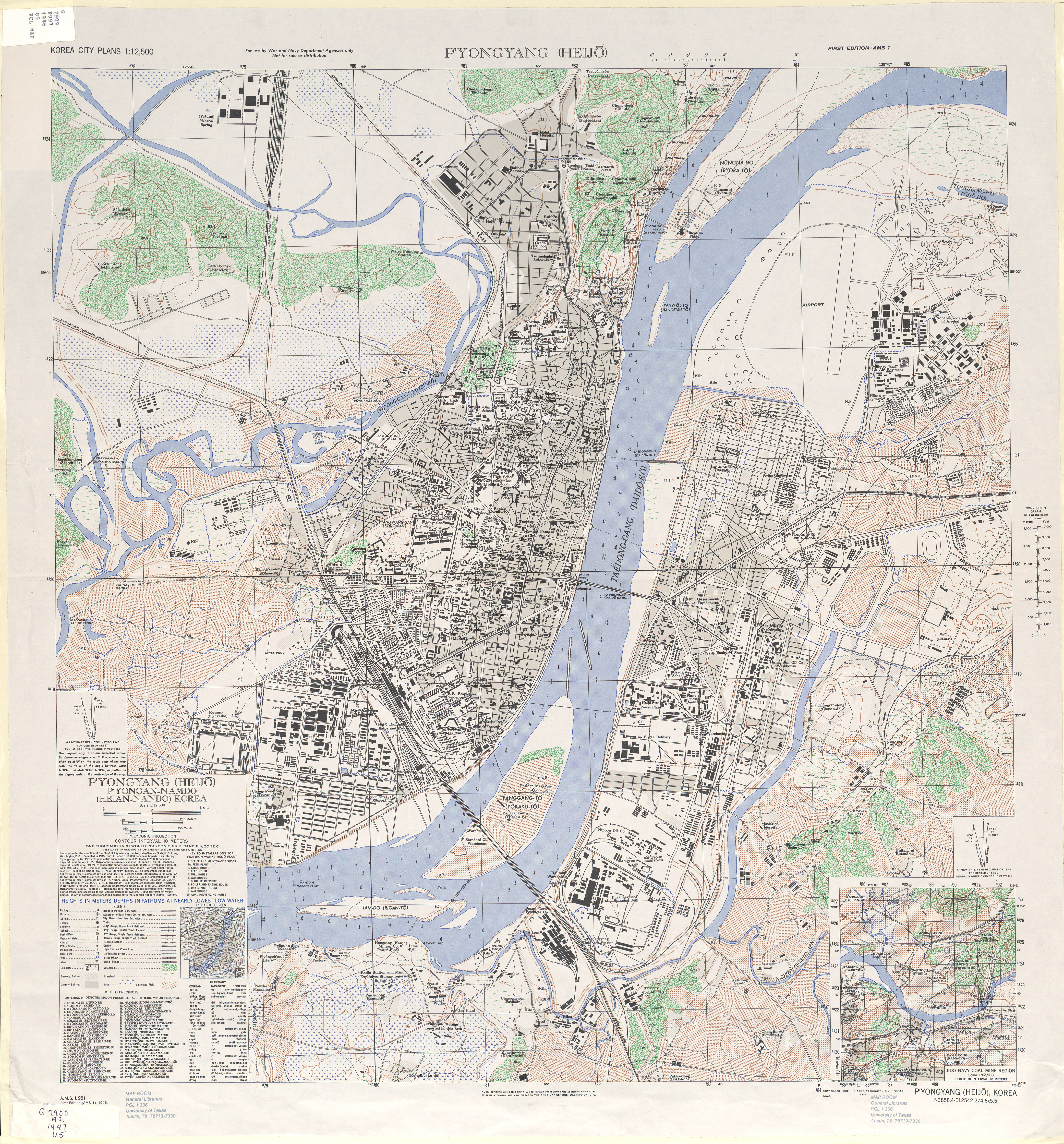
{{Information |Description={{en|1=1946 Map of Pyongyang (Heijo), North Korea by the Army Map Service, U.S. Army}} |Source=http://www.lib.utexas.edu/maps/ams/korea_city_plans/txu-oclc-6565231.jpg |Author=Army Map Service, U.S. Army, Washington D.C. |Date=1
ไฟล, pyongyangarmymapservice1946, ไฟล, ประว, ไฟล, หน, าท, ภาพน, การใช, ไฟล, วนกลาง, อม, ลเก, ยวก, บภาพขนาดของต, วอย, างน, กเซล, ความละเอ, ยดอ, กเซล, กเซล, กเซล, กเซล, กเซล, กเซล, ภาพท, ความละเอ, ยดส, งกว, 8206, กเซล, ขนาดไฟล, เมกะไบต, ชน, ดไมม, image, jpeg, ปภ. ifl prawtiifl hnathimiphaphni karichiflswnklang khxmulekiywkbphaphkhnadkhxngtwxyangni 558 600 phikesl khwamlaexiydxun 223 240 phikesl 446 480 phikesl 714 768 phikesl 952 1 024 phikesl 1 905 2 048 phikesl 4 168 4 481 phikesl duphaphthimikhwamlaexiydsungkwa 8206 4 168 4 481 phikesl khnadifl 7 74 emkaibt chnidimm image jpeg rupphaphhruxiflesiyngni tnchbbxyuthi khxmmxns raylaexiyddanlang epnkhxkhwamthiaesdngphlcak ifltnchbbinkhxmmxns khxmmxnsepnewbistinokhrngkarsahrbekbrwbrwmsuxesri thi khunsamarthchwyid khwamyx khaxthibayPyongyangarmymapservice1946 jpg English 1946 Map of Pyongyang Heijo North Korea by the Army Map Service U S Armywnthi ph s 2489aehlngthima http www lib utexas edu maps ams korea city plans txu oclc 6565231 jpgphusrangsrrkh Army Map Service U S Army Washington D C ewxrchnxun iflxunthiichiflni Pyongyangarmymapservice1946 Yanggak Bridge png phaphaephnthiekani khwrcathuksrangihmepnkrafiksewketxr sungmikhxdixikhlayprakar duephimetimthikhxmmxns suxtxngkarekbkwadsahrbsarsnethsephimetim hakphaphnimiinrupaebbkrafiksewketxrxyuaelw krunaxpohldaelaaethnthiaemaebbnidwy vector version available i chuxphaphihm i aenanaepnxyangyingihtngchuxiflewketxrihmnninrupaebb Pyongyangarmymapservice1946 svg aelwisaemaebb Vector version available hrux Vva sungimtxngichpharamietxr chuxphaphihmThis old map image was uploaded in the JPEG format even though it consists of non photographic data This information could be stored more efficiently or accurately in the PNG or SVG format If possible please upload a PNG or SVG version of this image without compression artifacts derived from a non JPEG source or with existing artifacts removed After doing so please tag the JPEG version with Superseded NewImage ext and remove this tag This tag should not be applied to photographs or scans For more information see BadJPEG karxnuyatichsiththi Public domain Public domain false falseThis file is a work of a U S Army soldier or employee taken or made as part of that person s official duties As a work of the U S federal government it is in the public domain in the United States العربية ব ল catala cestina Deutsch English espanol eesti فارسی suomi francais hrvatski magyar Bahasa Indonesia italiano 日本語 한국어 lietuviu makedonski മലയ ള မ န မ ဘ သ Nederlands polski portugues russkij sicilianu srpski srpski Turkce ukrayinska Tiếng Việt 中文 简体 中文 繁體 prawtiifl khlikwnthi ewlaephuxduiflthipraktinkhnann wnthi ewlarupyxkhnadphuichkhwamehn pccubn14 49 11 kumphaphnth 25534 168 4 481 7 74 emkaibt AniRaptor2001 Information Description en 1 1946 Map of Pyongyang Heijo North Korea by the Army Map Service U S Army Source http www lib utexas edu maps ams korea city plans txu oclc 6565231 jpg Author Army Map Service U S Army Washington D C Date 1 hnathimiphaphni hnatxipni oyngmathiphaphni epiyngyang karichiflswnklang wikixuntxipniichiflni karichbn de wikipedia org Pjongjang Strassenbahn Pjongjang karichbn en wikipedia org Pyongyang Air Base karichbn es wikipedia org Pionyang karichbn gl wikipedia org Pyongyang karichbn it wikipedia org Discussione Pyongyang fumetto karichbn ja wikipedia org 平壌直轄市 karichbn ko wikipedia org 평양시 릉라도 대동교 평양 대동강철교 벽라교 karichbn nds wikipedia org Pjongjang karichbn nl wikipedia org Tram van Pyongyang karichbn no wikipedia org Portal Korea Utvalgt kart Arkiv Portal Korea Utvalgt kart Uke 38 karichbn ps wikipedia org پیونګ یانګ karichbn www wikidata org Q15269446khxmulekiywkbphaph phaphnimikhxmulephimetim sungswnihymacakklxngdicitxlhruxsaeknenxrthisamarthekbkhxmuldngklawiwrwmkbphaphid thaphaphnithukprbprungaekikhhruxepliynaeplngcakedim khxmulbangxyangcayngkhngimepliynaeplngehmuxnphaphthithukprbprungaekikhnnphuphlitklxngi2s Digibook ScannerrunkhxngklxngSuprascan A0 10000 RGBkarcdwangphaphpktikhwamlaexiydaenwnxn300 dpikhwamlaexiydaenwtng300 dpisxftaewrthiichAdobe Photoshop 7 0aekikhphaphlasud10 18 29 mkrakhm 2550sepssiimidprbethiybkhwamkwangkhxngphaph8 335 phikeslkhwamsungkhxngphaph8 962 phikeslkhwamkwang10 024 phikeslkhwamsung9 720 phikeslbittxkhxmophennt8 8 8rupaebbkarbibxdimidbibxdphikeslkhxmophsichnRGBcanwnkhxmophennt3ewlathiaeplngepndicithl08 02 5 mkrakhm 2550wnthiaekikhkhxmulemtalasud09 50 5 mkrakhm 2550run IIM2 ekhathungcak https th wikipedia org wiki ifl Pyongyangarmymapservice1946 jpg, wikipedia, วิกิ หนังสือ, หนังสือ, ห้องสมุด,