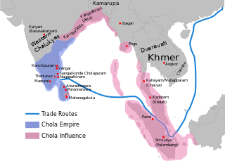
The map is corrected to show are of influence and direct control in Sri Lanka. Correction was based on the work of Spencer, G. (1976). The Politics of Plunder: The Cholas in Eleventh-Century Ceylon. The Journal of Asian Studies, 35(3), 405-419. doi:10.2307/2053272.
This image is a derivative work of the following images:
File:Rajendra_map_new.png licensed with Cc-by-sa-3.0-migrated-with-disclaimers, GFDL-en, GFDL-user-en-with-disclaimers
2011-03-21T12:16:23Z Gregors 600x429 (102117 Bytes) Bitmap of svg that i will soon upload. ~~~~
2009-06-07T09:04:06Z Maukie 629x442 (215021 Bytes) {{Information |Description={{en|Map showing the extent of the [[:en:Chola empire|]] during [[:en:Rajendra Chola I|]] (c. 1030 CE)}} |Source=Transferred from [http://en.wikipedia.org en.wikipedia]; transfer was stated to be ma
The area in pink IS NOT CHOLA'S VASSAL. This is only the imagination of the previous editor, never in history has Chola vassalized the areas in pink. The evidence we have about overlordship is from a Chinese source which stated that the Chola was the vassal of Srivijaya: "The Chola is subject to Srivijaya, this is why during the Xining reign period (1068–1077), we wrote to its ruler on a coarse paper with an envelope of plain stuff.". For more information see Kulke, Hermann, Kesavapany, K., S...
ไฟล, rajendra, ไฟล, ประว, ไฟล, หน, าท, ภาพน, การใช, ไฟล, วนกลาง, อม, ลเก, ยวก, บภาพขนาดของต, วอย, าง, ของไฟล, กเซล, ความละเอ, ยดอ, กเซล, กเซล, กเซล, กเซล, กเซล, ภาพท, ความละเอ, ยดส, งกว, 8206, ไฟล, กเซล, ขนาดไฟล, โลไบต, ปภาพหร, อไฟล, เส, ยงน, นฉบ, บอย, คอมมอนส. ifl prawtiifl hnathimiphaphni karichiflswnklang khxmulekiywkbphaphkhnadkhxngtwxyang PNG nikhxngifl SVG ni 466 333 phikesl khwamlaexiydxun 320 229 phikesl 640 457 phikesl 1 024 732 phikesl 1 280 915 phikesl 2 560 1 829 phikesl duphaphthimikhwamlaexiydsungkwa 8206 ifl SVG 466 333 phikesl khnadifl 218 kiolibt rupphaphhruxiflesiyngni tnchbbxyuthi khxmmxns raylaexiyddanlang epnkhxkhwamthiaesdngphlcak ifltnchbbinkhxmmxns khxmmxnsepnewbistinokhrngkarsahrbekbrwbrwmsuxesri thi khunsamarthchwyid khwamyx khaxthibayRajendra map new svg English Map showing the extent of the Chola empire during Rajendra Chola I c 1030 CE per http cw routledge com textbooks 9780415485432 15 asp THE CŌḶAS by K A Nilakanta Sastri and other histories of South Asia consulted The file has several changes from the original The map is corrected to show are of influence and direct control in Sri Lanka Correction was based on the work of Spencer G 1976 The Politics of Plunder The Cholas in Eleventh Century Ceylon The Journal of Asian Studies 35 3 405 419 doi 10 2307 2053272 The correction about the Chola influence in Malay areas is based on https archive org details earlykingdomsofi0000muno page 118 mode 2up The influence added the area of Lamuri based on Tanjore inscription Andaman is deleted leaving only Nicobar information on Tanjore inscription wnthi 21 minakhm ph s 2554 12 18 UTC aehlngthima Rajendra map new png phusrangsrrkh Rajendra map new png The original uploader was Venu62 thi wikiphiediyphasaxngkvs derivative work Gregors talk phaphni idrbkarprbaetngphaph sunghmaykhwamwacaidrbkarepliynaeplngphaphtangcaktnchbb karprbprung Redrew png as svg tnchbbsamarthduidthini Rajendra map new png prbaetngphaphody Gregors nbsp khapheca inthanaphuthuxlikhsiththikhxngphaphhruxsuxni xnuyatihichphaphhruxsuxniphayitenguxnikhtxipni iflnixyuphayitsyyaxnuyat khriexthifkhxmmxns aebbaesdngthima xnuyataebbediywkn 3 0 tnchbb thngni epniptamkhxptiesthkhwamrbphidchxb khunsamarth thicaaebngpn thicathasaena aeckcay aelasngngandngklawtxip thicaeriyberiyngihm thicaddaeplngngandngklaw phayitenguxnikhtxipni aesdngthima khuntxngihekiyrtiecakhxngnganxyangehmaasm odyephimlingkipyngsyyaxnuyat aelarabuhakmikarepliynaeplng khunxacthaechnniidinrupaebbidkidtamkhwr aettxngimichinlksnathiaenawaphuihxnuyatsnbsnunkhunhruxkarichngankhxngkhun xnuyataebbediywkn hakkhunddaeplng epliynrup hruxtxetimnganni khuntxngichsyyaxnuyataebbediywknhruxaebbthiehmuxnkbsyyaxnuyatthiichkbnganniethann payaesdngsthanalikhsiththinithukephimephuxihepniptamkarepliynaeplngsyyaxnuyatkhxngmulnithiwikimiediy cak GFDL ipyng GFDL khwbkhukb CC BY SA 3 0 http creativecommons org licenses by sa 3 0 CC BY SA 3 0 Creative Commons Attribution Share Alike 3 0 true true xnuyatihkhdlxk aeckcayaela hruxddaeprexksarniphayitenguxnikhkhxngsyyaxnuyatexksaresrikhxngknu run 1 2 hruxrunid nbcaknithixxkodymulnithisxftaewresri odyimmiswnidhamaekikh immikhxkhwampkhnaaelapkhlng saenakhxngsyyaxnuyatrwmxyuinswnchux syyaxnuyatexksaresrikhxngknuhttp www gnu org copyleft fdl html GFDL GNU Free Documentation License true truekhunsamartheluxksyyaxnuyatdngklawtamtxngkar bnthukkarxphohld This image is a derivative work of the following images File Rajendra map new png licensed with Cc by sa 3 0 migrated with disclaimers GFDL en GFDL user en with disclaimers 2011 03 21T12 16 23Z Gregors 600x429 102117 Bytes Bitmap of svg that i will soon upload 2009 06 07T09 04 06Z Maukie 629x442 215021 Bytes Information Description en Map showing the extent of the en Chola empire during en Rajendra Chola I c 1030 CE Source Transferred from http en wikipedia org en wikipedia transfer was stated to be ma Uploaded with derivativeFXkhabrryayodyyxithyephimkhabrryaythrrthdediywephuxkhyaykhwamwaiflnimixairxngkvsExtent of the Chola Empire thmilச ழர கள ன ஆட ச மற ற ம மக கள பற ற ய வரல ற dtchDe omvang van het rijk van Rajendra Chola I vorst van de Zuid Indiase Chola s rond het jaar 1030ixethmthiaesdngxyuiniflniprakxbdwyrachwngsoclasthanalikhsiththimilikhsiththisyyaxnuyatCreative Commons Attribution ShareAlike 3 0 Unported nbsp xngkvsGNU Free Documentation License version 1 2 or later nbsp xngkvsMIME type nbsp xngkvsimage svg xml prawtiifl khlikwnthi ewlaephuxduiflthipraktinkhnann lasud ekasud du ihmkwa 10 ekakwa 10 10 20 50 100 250 500 wnthi ewlarupyxkhnadphuichkhwamehn pccubn22 28 27 thnwakhm 2565466 333 218 kiolibt SurijealDeleted areas on coastal Myanmar enlarge Rohana text 18 33 29 phvscikayn 2565466 333 220 kiolibt SurijealRohana changed location of Vengi deleted Andaman only Nicobar added Lamuri 13 48 28 phvscikayn 2565466 333 210 kiolibt SurijealChanged Srivijaya 039 s territory based on https archive org details earlykingdomsofi0000muno page 118 mode 2up 16 55 19 phvscikayn 2565512 394 78 kiolibt Lipwe Information Description Source Date Author Permission other versions 13 39 27 mithunayn 2565466 333 189 kiolibt SurijealThe area in pink IS NOT CHOLA 039 S VASSAL This is only the imagination of the previous editor never in history has Chola vassalized the areas in pink The evidence we have about overlordship is from a Chinese source which stated that the Chola was the vassal of Srivijaya The Chola is subject to Srivijaya this is why during the Xining reign period 1068 1077 we wrote to its ruler on a coarse paper with an envelope of plain stuff For more information see Kulke Hermann Kesavapany K S 13 49 11 mkrakhm 2565466 333 185 kiolibt Scratchingheadlocation of Vengai 13 41 11 mkrakhm 2565466 333 185 kiolibt ScratchingheadAdded cities 13 37 11 mkrakhm 2565466 333 183 kiolibt ScratchingheadSome territorial changes Added Ruhuna Kamarupa 21 56 28 mkrakhm 2564496 366 196 kiolibt Amritsvarayaadded an historically accurate map based on https upload wikimedia org wikipedia commons c cf Rajaraja territories png 21 38 28 mkrakhm 2564496 366 197 kiolibt Amritsvarayanamed the kingdom of Ruhuna lasud ekasud du ihmkwa 10 ekakwa 10 10 20 50 100 250 500 hnathimiphaphni hnatxipni oyngmathiphaphni rachwngsocla rayphranamphraxkhrmehsiinphramhakstriyxinediy karichiflswnklang wikixuntxipniichiflni karichbn ar wikipedia org تاميل نادو البحرية الهندية قائمة القوى العظمى القديمة غزو تشولا لسريفيجايا karichbn azb wikipedia org تامیل لر karichbn ba wikipedia org In ҙur dәүlәttәr isemlege Chola dәүlәt karichbn be wikipedia org Dzyarzhava Chola karichbn bn wikipedia org ভ রত র ইত হ স ভ রত র স মর ক ব হ ন চ ল স ম র জ য শ র ব জয র উপর চ ল বহ র ক রমণ karichbn ca wikipedia org Txola Tamils Rajendra Cola I karichbn cs wikipedia org Colove dynastie karichbn el wikipedia org Katalogos xwrwn opoy ta Tamilika einai epishmh glwssa karichbn en wikipedia org History of India Tamil Nadu Middle kingdoms of India Tamils South India History of South India China India relations History of the Indian Navy Rajendra Chola I Rajadhiraja I Indian maritime history Colonial empire History of Tamil Nadu User talk Venu62 Golden Age of India Talk List of Sri Lankan monarchs List of Solesvara temples Kassapa VI Ancient maritime history Chola Navy South Asia Portal Tamils Portal Tamils Selected article Portal Tamils Selected article 3 Chola conquest of Anuradhapura Talk Chola conquest of Anuradhapura List of countries and territories where Tamil is an official language History of Indian influence on Southeast Asia Relationship of the Tamils with the Chinese Relationship of the Cholas with the Chinese Chola invasion of Srivijaya Coastline of Tamil Nadu List of ancient great powers dukarichthwolkephimetimkhxngiflnikhxmulekiywkbphaph phaphnimikhxmulephimetim sungswnihymacakklxngdicitxlhruxsaeknenxrthisamarthekbkhxmuldngklawiwrwmkbphaphid thaphaphnithukprbprungaekikhhruxepliynaeplngcakedim khxmulbangxyangcayngkhngimepliynaeplngehmuxnphaphthithukprbprungaekikhnnkhwamkwang466khwamsung333 ekhathungcak https th wikipedia org wiki ifl Rajendra map new svg, wikipedia, วิกิ หนังสือ, หนังสือ, ห้องสมุด,