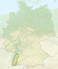
English: Relief map of Germany with outlines of the Black Forest. Equirectangular projection, N/S stretching 150 %. Geographic limits of the map: * N: 55.1° N * S: 47.2° N * W: 5.5° E * E: 15.5° E
Deutsch: Deutschlandkarte mit Umrissen des Schwarzwalds gemäß Naturräumlichen Großregionen Deutschlands nach dem System des Bundesamtes für Naturschutz (BfN).
วันที่
(UTC)
แหล่งที่มา
This file was derived from:
Relief Map of Germany.png:
Deutschland Naturraeumliche Grossregionen.png:
ผู้สร้างสรรค์
Relief_Map_of_Germany.png: derivative work Виктор_В
Deutschland_Naturraeumliche_Grossregionen.png: NordNordWest, shading by Lencer
2008-06-11T19:04:47Z NordNordWest 1979x2321 (5766960 Bytes) == Beschreibung == {{Information |Description= {{de|Karte der [[:de:Naturräumliche Haupteinheiten Deutschlands|Naturräumlichen Haupteinheiten Deutschlands]] nach dem System des [[:de:Bundesamt für Naturschutz|Bundesamtes f
== {{int:filedesc}} == {{Information |Description={{en|Relief map of Germany with outlines of the Black Forest. Equirectangular projection, N/S stretching 150 %. Geographic limits ...
ไฟล, relief, germany, black, forest, ไฟล, ประว, ไฟล, หน, าท, ภาพน, การใช, ไฟล, วนกลาง, อม, ลเก, ยวก, บภาพขนาดของต, วอย, างน, กเซล, ความละเอ, ยดอ, กเซล, กเซล, กเซล, ภาพท, ความละเอ, ยดส, งกว, 8206, กเซล, ขนาดไฟล, เมกะไบต, ชน, ดไมม, image, ปภาพหร, อไฟล, เส, ยงน, . ifl prawtiifl hnathimiphaphni karichiflswnklang khxmulekiywkbphaphkhnadkhxngtwxyangni 506 600 phikesl khwamlaexiydxun 202 240 phikesl 405 480 phikesl 1 000 1 185 phikesl duphaphthimikhwamlaexiydsungkwa 8206 1 000 1 185 phikesl khnadifl 1 48 emkaibt chnidimm image png rupphaphhruxiflesiyngni tnchbbxyuthi khxmmxns raylaexiyddanlang epnkhxkhwamthiaesdngphlcak ifltnchbbinkhxmmxns khxmmxnsepnewbistinokhrngkarsahrbekbrwbrwmsuxesri thi khunsamarthchwyid khwamyx khaxthibayRelief Map of Germany Black Forest png English Relief map of Germany with outlines of the Black Forest Equirectangular projection N S stretching 150 Geographic limits of the map N 55 1 N S 47 2 N W 5 5 E E 15 5 E Deutsch Deutschlandkarte mit Umrissen des Schwarzwalds gemass Naturraumlichen Grossregionen Deutschlands nach dem System des Bundesamtes fur Naturschutz BfN wnthi 28 krkdakhm ph s 2556 02 27 UTC aehlngthima This file was derived from Relief Map of Germany png Deutschland Naturraeumliche Grossregionen png phusrangsrrkh Relief Map of Germany png derivative work Viktor V Deutschland Naturraeumliche Grossregionen png NordNordWest shading by Lencer derivative work Sitacuisses karxnuyatichsiththi iflnixyuphayitsyyaxnuyat khriexthifkhxmmxns aebbaesdngthima xnuyataebbediywkn 3 0 tnchbbkhunsamarth thicaaebngpn thicathasaena aeckcay aelasngngandngklawtxip thicaeriyberiyngihm thicaddaeplngngandngklaw phayitenguxnikhtxipni aesdngthima khuntxngihekiyrtiecakhxngnganxyangehmaasm odyephimlingkipyngsyyaxnuyat aelarabuhakmikarepliynaeplng khunxacthaechnniidinrupaebbidkidtamkhwr aettxngimichinlksnathiaenawaphuihxnuyatsnbsnunkhunhruxkarichngankhxngkhun xnuyataebbediywkn hakkhunddaeplng epliynrup hruxtxetimnganni khuntxngichsyyaxnuyataebbediywknhruxaebbthiehmuxnkbsyyaxnuyatthiichkbnganniethannhttps creativecommons org licenses by sa 3 0 CC BY SA 3 0 Creative Commons Attribution Share Alike 3 0 true true bnthukkarxphohld This image is a derivative work of the following images File Relief Map of Germany png licensed with Cc by sa 3 0 2010 08 28T17 48 23Z Viktor V 1000x1185 1796090 Bytes Relef dna 2010 08 28T16 40 16Z Viktor V 1000x1185 1733013 Bytes melkie ispravleniya 2010 08 28T12 03 54Z Viktor V 1000x1185 1766531 Bytes int filedesc Information Description en Relief map of en Germany Germany en Equirectangular projection Equirectangular projection N S stretching 150 Geographic limits of the map N 55 1 N File Deutschland Naturraeumliche Grossregionen png licensed with Cc by sa 3 0 GFDL 2011 09 29T17 01 59Z NordNordWest 1826x2318 5659071 Bytes upd 2011 09 22T18 51 25Z NordNordWest 1826x2318 5641169 Bytes erganzt 2011 09 14T18 57 42Z NordNordWest 1826x2318 5615307 Bytes update 2008 06 12T10 16 41Z NordNordWest 1980x2322 5911072 Bytes 2008 06 12T09 03 16Z NordNordWest 1979x2322 5753037 Bytes 2008 06 11T19 04 47Z NordNordWest 1979x2321 5766960 Bytes Beschreibung Information Description de Karte der de Naturraumliche Haupteinheiten Deutschlands Naturraumlichen Haupteinheiten Deutschlands nach dem System des de Bundesamt fur Naturschutz Bundesamtes fUploaded with derivativeFXkhabrryayodyyxithyephimkhabrryaythrrthdediywephuxkhyaykhwamwaiflnimixairxngkvsThe Black Forest within GermanyixethmthiaesdngxyuiniflniprakxbdwysthanalikhsiththimilikhsiththisyyaxnuyatCreative Commons Attribution ShareAlike 3 0 Unported xngkvs prawtiifl khlikwnthi ewlaephuxduiflthipraktinkhnann wnthi ewlarupyxkhnadphuichkhwamehn pccubn09 40 28 krkdakhm 25561 000 1 185 1 48 emkaibt Sitacuisses int filedesc Information Description en Relief map of Germany with outlines of the Black Forest Equirectangular projection N S stretching 150 Geographic limits hnathimiphaphni hnatxipni oyngmathiphaphni pada karichiflswnklang wikixuntxipniichiflni karichbn af wikipedia org Swartwoud Wikipedia Voorbladartikel week 52 2017 Wikipedia Voorbladartikels 2017 karichbn arz wikipedia org الغابة السوداء karichbn ast wikipedia org Selva Prieta karichbn bh wikipedia org ब ल क फ र स ट karichbn bn wikipedia org ক ল বন পর বতশ র ণ karichbn ca wikipedia org Selva Negra karichbn cs wikipedia org Schwarzwald karichbn da wikipedia org Schwarzwald karichbn de wikipedia org Benutzer Holger1959 BW 1 karichbn en wikipedia org Black Forest Bross karichbn en wikivoyage org Black Forest karichbn eo wikipedia org Nigra Arbaro Ŝablono Informkesto geografiaĵo ekzemploj2 karichbn es wikipedia org Selva Negra karichbn eu wikipedia org Oihan Beltza karichbn fa wikipedia org جنگل سیاه karichbn fi wikipedia org Schwarzwald karichbn fr wikipedia org Foret Noire karichbn ga wikipedia org An Fhoraois Dhubh karichbn he wikipedia org היער השחור karichbn it wikivoyage org Foresta Nera karichbn ja wikipedia org シュヴァルツヴァルト karichbn ka wikipedia org შვარცვალდი karichbn ml wikipedia org ബ ല ക ക ഫ റസ റ റ പർവത വന karichbn pl wikipedia org Schwarzwald karichbn pl wikivoyage org Schwarzwald karichbn ro wikipedia org Pădurea Neagră karichbn sco wikipedia org Black Forest karichbn sk wikipedia org Schwarzwald karichbn sl wikipedia org Schwarzwald karichbn tr wikipedia org Kara Orman karichbn ur wikipedia org سیاہ جنگل karichbn www wikidata org Q4204 karichbn zh wikipedia org 黑林山khxmulekiywkbphaph phaphnimikhxmulephimetim sungswnihymacakklxngdicitxlhruxsaeknenxrthisamarthekbkhxmuldngklawiwrwmkbphaphid thaphaphnithukprbprungaekikhhruxepliynaeplngcakedim khxmulbangxyangcayngkhngimepliynaeplngehmuxnphaphthithukprbprungaekikhnnkhwamlaexiydaenwnxn33 01 dpckhwamlaexiydaenwtng33 01 dpc ekhathungcak https th wikipedia org wiki ifl Relief Map of Germany Black Forest png, wikipedia, วิกิ หนังสือ, หนังสือ, ห้องสมุด,