คำอธิบายSTS039-085-00E Lake Balkhash, Kazakhstan April 1991.jpg
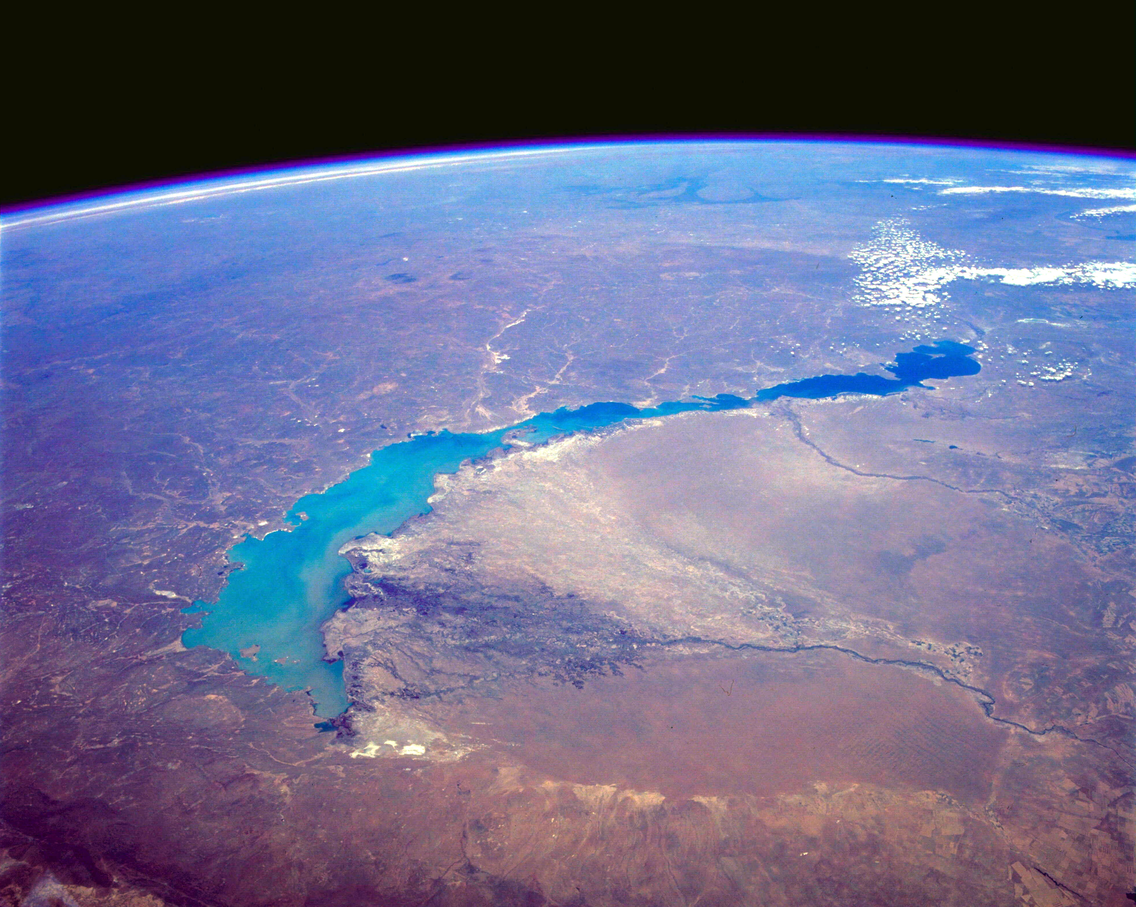
English: STS039-085-00E Lake Balkhash, Kazakhstan April 1991 The turquoise waters of Lake Balkhash can be seen in this northeast-looking, high-oblique photograph. The lake covers 6560 square miles (17 000 square kilometers), is nearly 350 miles (565 kilometers) long, but is only 45 miles (72 kilometers) at its maximum width. The average depth of Lake Balkhash is 20 feet (6 meters), but the lake reaches a maximum depth of 85 feet (26 meters) in its western half. Lake Balkhash extends from the Betpak Steppe in the west to the Kazakh Hills in the northeast. Visible in the photograph to the north of the lake is a vast undulating plain, and south-southeast of the lake are the Ili River and its delta. The Ili River separates two deserts. The larger, sandy Sary-Ishikotrau Desert lies northeast of the Ili River. A much smaller river, the Karatal, traverses this desert and empties into the eastern portion of Lake Balkhash. The Taukum Desert (brownish color) can be seen southwest of the Ili River. A large sandbar or spit (center of the photograph) separates the eastern, shallower, more saline part of Lake Balkhash from the deeper, fresher water of the western portion of the lake. The Ili River is fed by melting snow and glaciers of the Tien Shan ranges in China south of the lake (not visible in the photograph). Lake Balkhash has no river outlet and, even with the influx of fresh water from the Ili River, is shrinking because of evaporation; however, its rate of shrinkage is much less than that of the Aral Sea, which juts into Kazakhstan much farther to the west.
ไฟล, sts039, lake, balkhash, kazakhstan, april, 1991, ไฟล, ประว, ไฟล, หน, าท, ภาพน, การใช, ไฟล, วนกลางขนาดของต, วอย, างน, กเซล, ความละเอ, ยดอ, กเซล, กเซล, กเซล, กเซล, กเซล, กเซล, ภาพท, ความละเอ, ยดส, งกว, 8206, กเซล, ขนาดไฟล, เมกะไบต, ชน, ดไมม, image, jpeg, ปภ. ifl prawtiifl hnathimiphaphni karichiflswnklangkhnadkhxngtwxyangni 751 600 phikesl khwamlaexiydxun 301 240 phikesl 601 480 phikesl 962 768 phikesl 1 280 1 022 phikesl 2 560 2 044 phikesl 3 948 3 153 phikesl duphaphthimikhwamlaexiydsungkwa 8206 3 948 3 153 phikesl khnadifl 1 76 emkaibt chnidimm image jpeg rupphaphhruxiflesiyngni tnchbbxyuthi khxmmxns raylaexiyddanlang epnkhxkhwamthiaesdngphlcak ifltnchbbinkhxmmxns khxmmxnsepnewbistinokhrngkarsahrbekbrwbrwmsuxesri thi khunsamarthchwyid khwamyx khaxthibaySTS039 085 00E Lake Balkhash Kazakhstan April 1991 jpg English STS039 085 00E Lake Balkhash Kazakhstan April 1991 The turquoise waters of Lake Balkhash can be seen in this northeast looking high oblique photograph The lake covers 6560 square miles 17 000 square kilometers is nearly 350 miles 565 kilometers long but is only 45 miles 72 kilometers at its maximum width The average depth of Lake Balkhash is 20 feet 6 meters but the lake reaches a maximum depth of 85 feet 26 meters in its western half Lake Balkhash extends from the Betpak Steppe in the west to the Kazakh Hills in the northeast Visible in the photograph to the north of the lake is a vast undulating plain and south southeast of the lake are the Ili River and its delta The Ili River separates two deserts The larger sandy Sary Ishikotrau Desert lies northeast of the Ili River A much smaller river the Karatal traverses this desert and empties into the eastern portion of Lake Balkhash The Taukum Desert brownish color can be seen southwest of the Ili River A large sandbar or spit center of the photograph separates the eastern shallower more saline part of Lake Balkhash from the deeper fresher water of the western portion of the lake The Ili River is fed by melting snow and glaciers of the Tien Shan ranges in China south of the lake not visible in the photograph Lake Balkhash has no river outlet and even with the influx of fresh water from the Ili River is shrinking because of evaporation however its rate of shrinkage is much less than that of the Aral Sea which juts into Kazakhstan much farther to the west wnthi emsayn ph s 2534aehlngthima http eol jsc nasa gov sseop EFS photoinfo pl PHOTO STS039 85 Ephusrangsrrkh NASA karxnuyatichsiththi Public domain Public domain false falsephaphniepnsatharnsmbti enuxngcakepnphaphthisrangkhunodyxngkhkarbriharkarbinaelaxwkasaehngchati NASA sungtamnoybaydanlikhsiththikhxngnasarabuiwwa phaphaelasuxtang khxngnasaimidrbkarkhumkhrxngodylikhsiththiykewncarabuiwwamilikhsiththi duephimthi hnanoybaydanlikhsiththikhxngnasa hrux noybaykarichphaphkhxng JPLkhaetuxn karich olokkhxngnasa ekhruxnghmayaelaekhruxngpradbkhxngnasa thukcakddwykdhmayshrthxemrikainlksna 14 khxngkhxbngkhbthangrachkarshrthxemrika swnthi 1221 ewbistkhxngnasaekbrwbrwmphaphthimacakxngkhkarxwkasosewiyt xngkhkarxwkasaehngchatirsesiy aelaxngkhkarxwkasthimiichxngkhkarxwkaskhxngshrthxemrika epncanwnmak phaphehlaniimcaepntxngepnsatharnsmbtiesmxip phaphhruxsuxthimacak klxngothrthrrsnxwkashbebil xacmilikhsiththi hakphaphhruxsuxnnimidrabuchdecnwamacak sthabnwithyasastrklxngothrthrrsnxwkas 1 phaphhruxsuxthnghmdthimacakekhruxngmuxkhxng okhrngkarsuksadwngxathityaelalmsuriya milikhsiththi karnaphaphhruxsuxcakokhrngkaripichnxkehnuxcakkarichephuxkarkhahruxephuxkarsuksa txngidrbxnuyatkxn 2 phaphthithukkhdeluxkihepn phaphdarasastrpracawn APOD bnewbistkhxng APOD xacmilikhsiththi 3 bnthukkarxphohld naekhacak en wikipedia mayngkhxmmxns ody C messier odyich CommonsHelper The original description page was here All following user names refer to en wikipedia 2012 05 29 09 52 Lukemcurley 3948 3153 1846896 bytes Cropped some of the black space from the top of the photo to focus on the lake 2012 05 29 09 39 Lukemcurley 3960 4001 1289732 bytes Uploading a public domain item using Wikipedia File Upload Wizard File Upload Wizard khabrryayodyyxithyephimkhabrryaythrrthdediywephuxkhyaykhwamwaiflnimixairixethmthiaesdngxyuiniflniprakxbdwywnthisrang wnkxtngemsayn 1991 prawtiifl khlikwnthi ewlaephuxduiflthipraktinkhnann wnthi ewlarupyxkhnadphuichkhwamehn pccubn10 43 18 kumphaphnth 25573 948 3 153 1 76 emkaibt OgreBot BOT Reverting to most recent version before archival 10 43 18 kumphaphnth 25573 960 4 001 1 23 emkaibt OgreBot BOT Uploading old version of file from en wikipedia originally uploaded on 2012 05 29 09 39 58 by Lukemcurley 00 12 17 kumphaphnth 25573 948 3 153 1 76 emkaibt File Upload Bot Magnus Manske Transfered from en wikipedia by User C messier using CommonsHelper hnathimiphaphni hnatxipni oyngmathiphaphni thaelsabblkhch karichiflswnklang wikixuntxipniichiflni karichbn ar wikipedia org بحيرة بالكاش karichbn ast wikipedia org Llagu Baljash karichbn br wikipedia org Lenn Balqach karichbn ca wikipedia org Balkhaix karichbn cy wikipedia org Llyn Balkhash karichbn el wikipedia org Limnh Mpalkas karichbn en wikipedia org Lake Balkhash Wikipedia Recent additions 2010 May karichbn en wikiquote org William Gibson karichbn eo wikipedia org Balkaŝo karichbn es wikipedia org Lago Baljash Geografia de Kazajistan karichbn eu wikipedia org Balkhax aintzira karichbn fi wikipedia org Balkasjarvi karichbn fr wikipedia org Lac Balkhach karichbn gl wikipedia org Lago Balkhash karichbn he wikipedia org ימת בלחש karichbn id wikipedia org Danau Balkhash karichbn ja wikipedia org バルハシ湖 karichbn kk wikipedia org Balkash karichbn kn wikipedia org ಬ ಲ ಖ ಶ ಸರ ವರ karichbn ko wikipedia org 발하시호 karichbn lfn wikipedia org Lago Balcax karichbn mk wikipedia org Balhashko Ezero karichbn mr wikipedia org ब लख श सर वर karichbn oc wikipedia org Lac Balqash karichbn pa wikipedia org ਬਲਖਸ ਝ ਲ karichbn simple wikipedia org Lake Balqash karichbn sl wikipedia org Balhasko jezero karichbn sv wikipedia org Balchasjsjon karichbn sw wikipedia org Ziwa Balkhash karichbn tg wikipedia org Balhash karichbn vi wikipedia org Hồ Balkhash karichbn www wikidata org Q134485 karichbn zh yue wikipedia org 巴爾喀什湖 karichbn zh wikipedia org 巴尔喀什湖 哈萨克斯坦旅游业 ekhathungcak https th wikipedia org wiki ifl STS039 085 00E Lake Balkhash Kazakhstan April 1991 jpg, wikipedia, วิกิ หนังสือ, หนังสือ, ห้องสมุด,