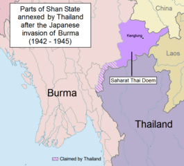
English: Parts of Shan State annexed by Thailand after the Japanese invasion of Burma. The map shows in purple the actual territories east of the Salween (Kengtung and part of Mongpan State) that were sanctioned by the Japanese authorities to become a new Thai province. Not all the territories claimed by Thailand in the Shan and Kayah states were granted by the Japanese. Note: This is not a map of the farthest penetration of the Thai army accompanying the Japanese military in their Burma campaign.
Mandalay and Taunggiy was as far as the Thai troops advanced, but the map is about the parts annexed by Thailand as 'Saharat Thai Doem'. It is not a map of the farthest penetration of the Phayap Army
ไฟล, saharat, thai, doem, ไฟล, ประว, ไฟล, หน, าท, ภาพน, การใช, ไฟล, วนกลาง, อม, ลเก, ยวก, บภาพขนาดของต, วอย, างน, กเซล, ความละเอ, ยดอ, กเซล, กเซล, กเซล, ภาพท, ความละเอ, ยดส, งกว, 8206, กเซล, ขนาดไฟล, โลไบต, ชน, ดไมม, image, ปภาพหร, อไฟล, เส, ยงน, นฉบ, บอย, คอม. ifl prawtiifl hnathimiphaphni karichiflswnklang khxmulekiywkbphaphkhnadkhxngtwxyangni 663 600 phikesl khwamlaexiydxun 265 240 phikesl 531 480 phikesl 962 870 phikesl duphaphthimikhwamlaexiydsungkwa 8206 962 870 phikesl khnadifl 189 kiolibt chnidimm image png rupphaphhruxiflesiyngni tnchbbxyuthi khxmmxns raylaexiyddanlang epnkhxkhwamthiaesdngphlcak ifltnchbbinkhxmmxns khxmmxnsepnewbistinokhrngkarsahrbekbrwbrwmsuxesri thi khunsamarthchwyid khwamyx khaxthibaySaharat Thai Doem map png English Parts of Shan State annexed by Thailand after the Japanese invasion of Burma The map shows in purple the actual territories east of the Salween Kengtung and part of Mongpan State that were sanctioned by the Japanese authorities to become a new Thai province Not all the territories claimed by Thailand in the Shan and Kayah states were granted by the Japanese Note This is not a map of the farthest penetration of the Thai army accompanying the Japanese military in their Burma campaign wnthi 27 singhakhm ph s 2557 17 40 21 aehlngthima ngankhxngtw phusrangsrrkh Xufanc karxnuyatichsiththi khapheca inthanaphuthuxlikhsiththikhxngphaphhruxsuxni xnuyatihichphaphhruxsuxniphayitenguxnikhtxipniiflnixyuphayitsyyaxnuyat khriexthifkhxmmxns aebbaesdngthima xnuyataebbediywkn 4 0 nanachatikhunsamarth thicaaebngpn thicathasaena aeckcay aelasngngandngklawtxip thicaeriyberiyngihm thicaddaeplngngandngklaw phayitenguxnikhtxipni aesdngthima khuntxngihekiyrtiecakhxngnganxyangehmaasm odyephimlingkipyngsyyaxnuyat aelarabuhakmikarepliynaeplng khunxacthaechnniidinrupaebbidkidtamkhwr aettxngimichinlksnathiaenawaphuihxnuyatsnbsnunkhunhruxkarichngankhxngkhun xnuyataebbediywkn hakkhunddaeplng epliynrup hruxtxetimnganni khuntxngichsyyaxnuyataebbediywknhruxaebbthiehmuxnkbsyyaxnuyatthiichkbnganniethannhttps creativecommons org licenses by sa 4 0 CC BY SA 4 0 Creative Commons Attribution Share Alike 4 0 true truekhabrryayodyyxithyephimkhabrryaythrrthdediywephuxkhyaykhwamwaiflnimixairixethmthiaesdngxyuiniflniprakxbdwyphusrangbangkhathiimmiixethmwikisnethschuxphusrangsrrkh Xufancchuxphuichwikimiediy Xufancyuxaraexl http commons wikimedia org wiki User XufancsthanalikhsiththimilikhsiththisyyaxnuyatCreative Commons Attribution ShareAlike 4 0 International nbsp xngkvswnthisrang wnkxtng27 singhakhm 2014thimakhxngiflkarsrangdngedimodyphuxpohld prawtiifl khlikwnthi ewlaephuxduiflthipraktinkhnann lasud ekasud du ihmkwa 10 ekakwa 10 10 20 50 100 250 500 wnthi ewlarupyxkhnadphuichkhwamehn pccubn20 01 24 phvsphakhm 2560962 870 189 kiolibt XufancUndid malicious revision by User Shoshui 10 37 12 minakhm 2559962 870 167 kiolibt ShoshuiReverted to version as of 07 52 6 November 2015 UTC 16 37 15 thnwakhm 2558962 870 193 kiolibt XufancCorrected title 16 08 15 thnwakhm 2558962 870 194 kiolibt XufancOther wording 15 59 15 thnwakhm 2558962 870 208 kiolibt XufancOther wording 08 57 9 phvscikayn 2558962 870 208 kiolibt Xufancstatus unclear region 10 03 7 phvscikayn 2558962 870 208 kiolibt XufancStatus unclear region 14 52 6 phvscikayn 2558962 870 167 kiolibt XufancMandalay and Taunggiy was as far as the Thai troops advanced but the map is about the parts annexed by Thailand as 039 Saharat Thai Doem 039 It is not a map of the farthest penetration of the Phayap Army 13 25 14 knyayn 2558962 870 166 kiolibt ShoshuiThe area include Mandalay and Taunggyi 13 16 14 knyayn 2558962 870 166 kiolibt ShoshuiThe area include Mandalay and Taunggyi lasud ekasud du ihmkwa 10 ekakwa 10 10 20 50 100 250 500 hnathimiphaphni hnatxipni oyngmathiphaphni klumrthkaehriyngaedng kntrwdi chayaednphma ithy praethsithyinsngkhramolkkhrngthisxng shrthithyedim karichiflswnklang wikixuntxipniichiflni karichbn en wikipedia org Karenni States Phayap Army Thailand in World War II Kantarawadi Saharat Thai Doem Kengtung State Myanmar Thailand border karichbn es wikipedia org Ocupacion japonesa de Tailandia karichbn fr wikipedia org Armee thailandaise Phayap Histoire de la Thailande pendant la Seconde Guerre mondiale Saharat Thai Doem karichbn it wikipedia org Invasione giapponese della Thailandia Saharat Thai Doem karichbn my wikipedia org ကရင န ပ ည နယ မ ကန ဒရဝတ နယ karichbn uk wikipedia org Tayiland pid chas Drugoyi svitovoyi vijni karichbn vi wikipedia org Saharat Thai Doem karichbn zh wikipedia org 中泰國境戰爭khxmulekiywkbphaph phaphnimikhxmulephimetim sungswnihymacakklxngdicitxlhruxsaeknenxrthisamarthekbkhxmuldngklawiwrwmkbphaphid thaphaphnithukprbprungaekikhhruxepliynaeplngcakedim khxmulbangxyangcayngkhngimepliynaeplngehmuxnphaphthithukprbprungaekikhnnkhwamlaexiydaenwnxn37 8 dpckhwamlaexiydaenwtng37 8 dpc ekhathungcak https th wikipedia org wiki ifl Saharat Thai Doem map png, wikipedia, วิกิ หนังสือ, หนังสือ, ห้องสมุด,