The original description page was here. All following user names refer to en.wikipedia.
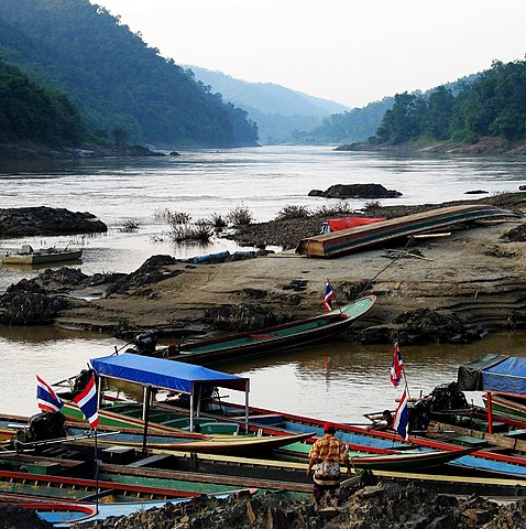
2008-04-23 13:27 Takeaway 548×550×??? (101250 bytes) {{Information |Description= The Salawin river (a.k.a. the Nujiang river in China) at the border village of Mae Sam Laep |Source=self-made |Date=2005-10-18 |Author=~~~ |other_versions= }}
{{BotMoveToCommons|en.wikipedia}} {{Information |Description={{en|The Salawin river (a.k.a. the Nujiang river in China) at the border village of Mae Sam Laep}} |Source=Transferred from [http://en.wikipedia.org en.wikipedia]; transferred to Commons by [[U
ไฟล, salawin, river, laep, ไฟล, ประว, ไฟล, หน, าท, ภาพน, การใช, ไฟล, วนกลาง, อม, ลเก, ยวก, บภาพขนาดของต, วอย, างน, กเซล, ความละเอ, ยดอ, กเซล, กเซล, กเซล, กเซล, กเซล, ภาพท, ความละเอ, ยดส, งกว, 8206, กเซล, ขนาดไฟล, เมกะไบต, ชน, ดไมม, image, jpeg, ปภาพหร, อไฟล, เ. ifl prawtiifl hnathimiphaphni karichiflswnklang khxmulekiywkbphaphkhnadkhxngtwxyangni 597 599 phikesl khwamlaexiydxun 239 240 phikesl 478 480 phikesl 765 768 phikesl 1 020 1 024 phikesl 1 594 1 600 phikesl duphaphthimikhwamlaexiydsungkwa 8206 1 594 1 600 phikesl khnadifl 1 17 emkaibt chnidimm image jpeg rupphaphhruxiflesiyngni tnchbbxyuthi khxmmxns raylaexiyddanlang epnkhxkhwamthiaesdngphlcak ifltnchbbinkhxmmxns khxmmxnsepnewbistinokhrngkarsahrbekbrwbrwmsuxesri thi khunsamarthchwyid khwamyx taaehnngthitngklxng17 nbsp 58 nbsp 53 1 nbsp ehnux 97 nbsp 44 nbsp 15 99 nbsp tawnxxk nbsp phaphniaelaphaphxun n sthanthiediywknthi OpenStreetMap17 981416 97 737775 khaxthibaySalawin river at Mae Sam Laep jpg English The Salawin river a k a the Nujiang river in China at the border village of Mae Sam Laep Myanmar is on the left bank wnthi 23 emsayn ph s 2551 original upload date Original text 2005 10 18 aehlngthima ngankhxngtw Original text self made phusrangsrrkh Takeaway talk karxnuyatichsiththi Takeaway thi wikiphiediyphasaxngkvs inthanaphuthuxlikhsiththikhxngphaphhruxsuxni xnuyatihichphaphhruxsuxniphayitenguxnikhtxipniiflnixyuphayitsyyaxnuyat khriexthifkhxmmxns aebbaesdngthima xnuyataebbediywkn 3 0 tnchbbkaraesdngthima Takeaway thi wikiphiediyphasaxngkvskhunsamarth thicaaebngpn thicathasaena aeckcay aelasngngandngklawtxip thicaeriyberiyngihm thicaddaeplngngandngklaw phayitenguxnikhtxipni aesdngthima khuntxngihekiyrtiecakhxngnganxyangehmaasm odyephimlingkipyngsyyaxnuyat aelarabuhakmikarepliynaeplng khunxacthaechnniidinrupaebbidkidtamkhwr aettxngimichinlksnathiaenawaphuihxnuyatsnbsnunkhunhruxkarichngankhxngkhun xnuyataebbediywkn hakkhunddaeplng epliynrup hruxtxetimnganni khuntxngichsyyaxnuyataebbediywknhruxaebbthiehmuxnkbsyyaxnuyatthiichkbnganniethannhttps creativecommons org licenses by sa 3 0 CC BY SA 3 0 Creative Commons Attribution Share Alike 3 0 true true xnuyatihkhdlxk aeckcayaela hruxddaeprexksarniphayitenguxnikhkhxngsyyaxnuyatexksaresrikhxngknu run 1 2 hruxrunid nbcaknithixxkodymulnithisxftaewresri odyimmiswnidhamaekikh immikhxkhwampkhnaaelapkhlng saenakhxngsyyaxnuyatrwmxyuinswnchux syyaxnuyatexksaresrikhxngknuhttp www gnu org copyleft fdl html GFDL GNU Free Documentation License true truekhunsamartheluxksyyaxnuyatdngklawtamtxngkar bnthukkarxphohldnaekhacak en wikipedia mayngkhxmmxns ody Takeaway odyich CommonsHelperThe original description page was here All following user names refer to en wikipedia 2008 04 23 13 27 Takeaway 548 550 101250 bytes Information Description The Salawin river a k a the Nujiang river in China at the border village of Mae Sam Laep Source self made Date 2005 10 18 Author other versions khabrryayodyyxithyephimkhabrryaythrrthdediywephuxkhyaykhwamwaiflnimixairixethmthiaesdngxyuiniflniprakxbdwysthanalikhsiththimilikhsiththisyyaxnuyatGNU Free Documentation License version 1 2 or later nbsp xngkvsCreative Commons Attribution ShareAlike 3 0 Unported nbsp xngkvsthimakhxngiflkarsrangdngedimodyphuxpohldwnthisrang wnkxtng23 emsayn 2008coordinates of the point of view nbsp xngkvs17 58 53 098 N 97 44 15 990 EbnthukphaphdwyCanon PowerShot G6 nbsp xngkvsexposure time nbsp xngkvs0 003125 winathif number nbsp xngkvs4focal length nbsp xngkvs17 59375 milliemtrMIME type nbsp xngkvsimage jpeg prawtiifl khlikwnthi ewlaephuxduiflthipraktinkhnann wnthi ewlarupyxkhnadphuichkhwamehn pccubn19 59 20 thnwakhm 25521 594 1 600 1 17 emkaibt Takeawaysame image larger file and resolution 12 48 9 singhakhm 2551548 550 99 kiolibt File Upload Bot Magnus Manske BotMoveToCommons en wikipedia Information Description en The Salawin river a k a the Nujiang river in China at the border village of Mae Sam Laep Source Transferred from http en wikipedia org en wikipedia transferred to Commons by U hnathimiphaphni hnatxipni oyngmathiphaphni cnghwdaemhxngsxn xaephxsbemy xuthyanaehngchatisalawin aemnasalawin karichiflswnklang wikixuntxipniichiflni karichbn af wikipedia org Salween karichbn ar wikipedia org نهر سالوين نهر السلوين karichbn arz wikipedia org سد تاسانج karichbn azb wikipedia org سالوین چایی karichbn ban wikipedia org Taman Nasional Salawin karichbn be wikipedia org Saluin Indakitaj karichbn bg wikipedia org Tasang karichbn bh wikipedia org स लव न नद karichbn bn wikipedia org স লউইন নদ karichbn ca wikipedia org Salween karichbn ceb wikipedia org Ban Mae Sam Laep karichbn cy wikipedia org Afon Salawin karichbn de wikipedia org Saluen Amphoe Sop Moei Tasang Talsperre karichbn en wikipedia org Salween River Mae Hong Son province Sop Moei district Tasang Dam User Marcus334 Dams in Burma Hydropower dams in Myanmar Mae Sam Laep Salawin National Park karichbn en wikivoyage org Mae Sariang karichbn en wiktionary org Dorias karichbn es wikipedia org Rio Salween Parque nacional de Lum Nam Khong karichbn fa wikipedia org سد تاسنگ karichbn fi wikipedia org Salween karichbn fr wikipedia org Barrage de TaSang Amphoe Sop Moei karichbn fr wikivoyage org Province de Mae Hong Son Parcs nationaux de Thailande karichbn gl wikipedia org Rio Salween karichbn hi wikipedia org म ह ग स न प र न त स ल व न र ष ट र य उद य न karichbn hr wikipedia org Salven karichbn id wikipedia org Sungai Salween karichbn incubator wikimedia org Wt ksw ခ karichbn it wikipedia org Saluen Provincia di Mae Hong Son karichbn ja wikipedia org サルウィン川 karichbn ka wikipedia org მეჰონგსონის პროვინცია karichbn kk wikipedia org Ұzyndygy bojynsha ozender tizimi karichbn ko wikipedia org 매홍손주 솝므이군 karichbn la wikipedia org Saluen karichbn lt wikipedia org Salvinas dukarichthwolkephimetimkhxngiflnikhxmulekiywkbphaph phaphnimikhxmulephimetim sungswnihymacakklxngdicitxlhruxsaeknenxrthisamarthekbkhxmuldngklawiwrwmkbphaphid thaphaphnithukprbprungaekikhhruxepliynaeplngcakedim khxmulbangxyangcayngkhngimepliynaeplngehmuxnphaphthithukprbprungaekikhnnphuphlitklxngCanonrunkhxngklxngCanon PowerShot G6ewlaepidhnaklxng1 320 winathi 0 003125 khaexff 4ewlathibnthukphaph12 18 18 tulakhm 2548khwamyawofkselns17 59375 mm phuthayPicasa 2 6karcdwangphaphpktikhwamlaexiydaenwnxn96 dpikhwamlaexiydaenwtng96 dpiaekikhphaphlasud12 18 18 tulakhm 2548taaehnng Y aela Ckungklangrunexksif Exif 2 2ewlathiaeplngepndicithl12 18 18 tulakhm 2548khwamhmaykhxngaetlakhxmophenntY Cb Cr immikhaohmdkarbibxdphaph5khwamerwchtetxr0 3126220703125kharurbaesng A 4karchdechyaesng0rurbaesngkwangsud2 65625 APEX f 2 51 ohmdkarwdaesngaephtethirnaeflchimichaeflch rangbichaeflchrunaeflchphiksthirxngrb1sepssiimidprbethiybkhwamlaexiydranabofks X10 816 901408451khwamlaexiydranabofks Y10 816 901408451hnwykhwamlaexiydranabofksniwwithikarwdesnesxrcudediywtnchbbiflklxngthayphaphningdicithlkarpramwlphaphophlessspktiohmdexksophechxrexksophechxrxtonmtiiwtbalansiwtbalansxtonmtidicithlsum1chnidsinaekhpecxrpktirhsphaphed965efb3f30e1e9c1c6b483903bc687 ekhathungcak https th wikipedia org wiki ifl Salawin river at Mae Sam Laep jpg, wikipedia, วิกิ หนังสือ, หนังสือ, ห้องสมุด,