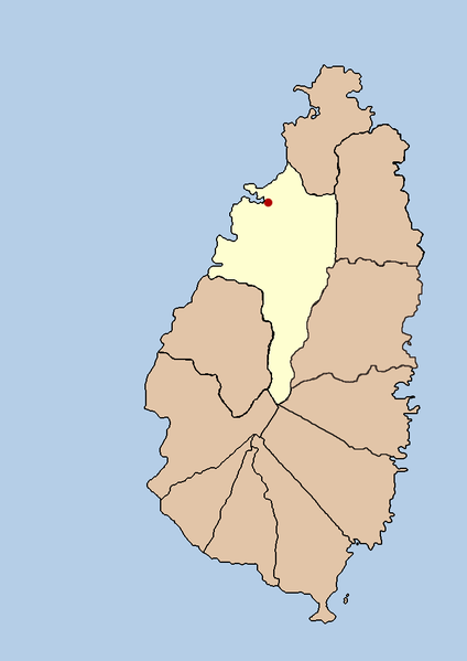
this is a political map showing the quarter of Castries on the island nation of Santa Lucia. I created it myself by using the GIMP to trace a public domain map that i found at the Perry-Castañeda Library Map Collection.
วันที่
21 กันยายน พ.ศ. 2548 (original upload date)
แหล่งที่มา
No machine-readable source provided. Own work assumed (based on copyright claims).
ผู้สร้างสรรค์
No machine-readable author provided. Doviende~commonswiki assumed (based on copyright claims).
Alemannisch ∙ العربية ∙ беларуская (тарашкевіца) ∙ български ∙ বাংলা ∙ català ∙ нохчийн ∙ čeština ∙ dansk ∙ Deutsch ∙ Ελληνικά ∙ English ∙ British English ∙ Esperanto ∙ español ∙ eesti ∙ euskara ∙ فارسی ∙ suomi ∙ français ∙ Frysk ∙ galego ∙ עברית ∙ hrvatski ∙ magyar ∙ հայերեն ∙ Bahasa Indonesia ∙ Ido ∙ italiano ∙ 日本語 ∙ ქართული ∙ 한국어 ∙ lietuvių ∙ македонски ∙ മലയാളം ∙ Bahasa Melayu ∙ norsk bokmål ∙ Plattdüütsch ∙ Nederlands ∙ norsk nynorsk ∙ norsk ∙ occitan ∙ polski ∙ português ∙ português do Brasil ∙ română ∙ русский ∙ sicilianu ∙ Scots ∙ slovenčina ∙ slovenščina ∙ српски / srpski ∙ svenska ∙ தமிழ் ∙ ไทย ∙ Türkçe ∙ татарча/tatarça ∙ українська ∙ vèneto ∙ Tiếng Việt ∙ 中文(简体) ∙ 中文(繁體) ∙ +/−
this is a political map showing the quarter of Castries on the island nation of Santa Lucia. I created it myself by using the GIMP to trace [http://www.lib.utexas.edu/maps/americas/saint_lucia.gif a public domain map that i found] at the Perry-Casta�
ไฟล, santa, lucia, castries, political, ไฟล, ประว, ไฟล, หน, าท, ภาพน, การใช, ไฟล, วนกลางขนาดของต, วอย, างน, กเซล, ความละเอ, ยดอ, กเซล, กเซล, กเซล, ภาพท, ความละเอ, ยดส, งกว, 8206, กเซล, ขนาดไฟล, โลไบต, ชน, ดไมม, image, ปภาพหร, อไฟล, เส, ยงน, นฉบ, บอย, คอมมอนส, . ifl prawtiifl hnathimiphaphni karichiflswnklangkhnadkhxngtwxyangni 424 599 phikesl khwamlaexiydxun 170 240 phikesl 339 480 phikesl 733 1 036 phikesl duphaphthimikhwamlaexiydsungkwa 8206 733 1 036 phikesl khnadifl 20 kiolibt chnidimm image png rupphaphhruxiflesiyngni tnchbbxyuthi khxmmxns raylaexiyddanlang epnkhxkhwamthiaesdngphlcak ifltnchbbinkhxmmxns khxmmxnsepnewbistinokhrngkarsahrbekbrwbrwmsuxesri thi khunsamarthchwyid khwamyx khaxthibaySanta lucia castries political png this is a political map showing the quarter of Castries on the island nation of Santa Lucia I created it myself by using the GIMP to trace a public domain map that i found at the Perry Castaneda Library Map Collection wnthi 21 knyayn ph s 2548 original upload date aehlngthima No machine readable source provided Own work assumed based on copyright claims phusrangsrrkh No machine readable author provided Doviende commonswiki assumed based on copyright claims karxnuyatichsiththi Public domain Public domain false falsekhapheca phuthuxlikhsiththiinnganni khxmxbnganihepnsatharnsmbti prakasnimiphlthwolkinbangpraeths karkrathadngklawxacimsamarththaidtamkdhmaykhaphecaxnuyatihthukkhnmisiththiinkarichiflniinthukehtuphlkarich odyimmimienguxnikh ewnaetkdhmayimxnuyatihthaechnnnphaphnimiphaphinrupaebbewketxr SVG hakphaph SVG thaihkaraesdngphldikwa hnathiichphaphnikhwrepliynipichphaph SVG aethn File Santa lucia castries political png File Saint Lucia district of Castries svg sahrbkhxmulephimetimekiywkbphaphewketxr duthi karepliynipichphaph SVG inkhxmmxnsnxkcaknisamarthduephimetimekiywkb khxmulekiywkbkarrxngrbphaph SVG sahrbsxftaewrmiediywiki id inphasaxunAlemannisch العربية belaruskaya tarashkevica blgarski ব ল catala nohchijn cestina dansk Deutsch Ellhnika English British English Esperanto espanol eesti euskara فارسی suomi francais Frysk galego עברית hrvatski magyar հայերեն Bahasa Indonesia Ido italiano 日本語 ქართული 한국어 lietuviu makedonski മലയ ള Bahasa Melayu norsk bokmal Plattduutsch Nederlands norsk nynorsk norsk occitan polski portugues portugues do Brasil romană russkij sicilianu Scots slovencina slovenscina srpski srpski svenska தம ழ ithy Turkce tatarcha tatarca ukrayinska veneto Tiếng Việt 中文 简体 中文 繁體 khabrryayodyyxithyephimkhabrryaythrrthdediywephuxkhyaykhwamwaiflnimixairixethmthiaesdngxyuiniflniprakxbdwysthanalikhsiththicopyrighted dedicated to the public domain by copyright holder xngkvsmilikhsiththisyyaxnuyatreleased into the public domain by the copyright holder xngkvswnthisrang wnkxtng21 knyayn 2005 prawtiifl khlikwnthi ewlaephuxduiflthipraktinkhnann wnthi ewlarupyxkhnadphuichkhwamehn pccubn10 43 21 knyayn 2548733 1 036 20 kiolibt Doviende commonswikithis is a political map showing the quarter of Castries on the island nation of Santa Lucia I created it myself by using the GIMP to trace http www lib utexas edu maps americas saint lucia gif a public domain map that i found at the Perry Casta hnathimiphaphni hnatxipni oyngmathiphaphni aekhstris karichiflswnklang wikixuntxipniichiflni karichbn af wikipedia org Castries karichbn am wikipedia org ካስትሪስ karichbn ban wikipedia org Castries karichbn cy wikipedia org Castries karichbn en wikipedia org Castries karichbn fa wikipedia org کاستریس بخش کاستریس karichbn fi wikipedia org Castries karichbn hi wikipedia org क स ट र ज karichbn hr wikipedia org Castries karichbn hu wikipedia org Castries karichbn id wikipedia org Castries karichbn incubator wikimedia org Wp kjh Kastri karichbn ja wikipedia org カストリーズ karichbn ko wikipedia org 캐스트리스구 karichbn lt wikipedia org Kastrio kvartalas karichbn mk wikipedia org Kastri Kastri chetvrt karichbn ml wikipedia org ക സ ട ര സ karichbn mr wikipedia org क स ट र झ karichbn nl wikipedia org Castries Saint Lucia karichbn nn wikipedia org Castries karichbn ps wikipedia org کاستریس karichbn sah wikipedia org Kastris karichbn sh wikipedia org Castries karichbn sv wikipedia org Castries karichbn ta wikipedia org க ஸ ட ர ஸ karichbn tr wikipedia org Castries karichbn ur wikipedia org کاستریس کاستریس کوارٹر karichbn vi wikipedia org Castries Castries quận karichbn yo wikipedia org Castries karichbn zh min nan wikipedia org Castries ekhathungcak https th wikipedia org wiki ifl Santa lucia castries political png, wikipedia, วิกิ หนังสือ, หนังสือ, ห้องสมุด,