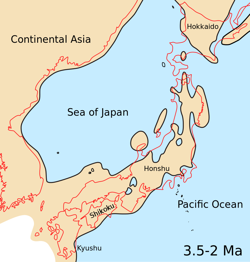
English: Map showing Japanese archipelago, Sea of Japan and surrounding part of continental East Asia in Middle Pliocene to Late Pliocene (3.5-2 Ma, 3.5-2 million years ago).
วันที่
แหล่งที่มา
Kameda Y. & Kato M. (2011). "Terrestrial invasion of pomatiopsid gastropods in the heavy-snow region of the Japanese Archipelago". BMC Evolutionary Biology11: 118. doi:10.1186/1471-2148-11-118. Figure 5C. Modified: added color of ocean.
ผู้สร้างสรรค์
Yuichi Kameda & Makoto Kato
เวอร์ชันอื่น
ไฟล์อื่นที่ใช้ไฟล์นี้: Sea of Japan Pliocene map He.jpg
{{validSVG}} {{Information |Description={{en|Map showing Japanese archipelago, Sea of Japan and surrounding part of continental East Asia in Middle Pliocene to Late Pliocene (3.5-2 Ma).}} |Source=Kameda Y. & Kato M. (2011). "Terrestrial invasion of pomati
ไฟล, japan, pliocene, ไฟล, ประว, ไฟล, หน, าท, ภาพน, การใช, ไฟล, วนกลาง, อม, ลเก, ยวก, บภาพขนาดของต, วอย, าง, ของไฟล, กเซล, ความละเอ, ยดอ, กเซล, กเซล, กเซล, กเซล, กเซล, ภาพท, ความละเอ, ยดส, งกว, 8206, ไฟล, กเซล, ขนาดไฟล, โลไบต, ปภาพหร, อไฟล, เส, ยงน, นฉบ, บอย, . ifl prawtiifl hnathimiphaphni karichiflswnklang khxmulekiywkbphaphkhnadkhxngtwxyang PNG nikhxngifl SVG ni 255 267 phikesl khwamlaexiydxun 229 240 phikesl 458 480 phikesl 733 768 phikesl 978 1 024 phikesl 1 956 2 048 phikesl duphaphthimikhwamlaexiydsungkwa 8206 ifl SVG 255 267 phikesl khnadifl 58 kiolibt rupphaphhruxiflesiyngni tnchbbxyuthi khxmmxns raylaexiyddanlang epnkhxkhwamthiaesdngphlcak ifltnchbbinkhxmmxns khxmmxnsepnewbistinokhrngkarsahrbekbrwbrwmsuxesri thi khunsamarthchwyid i sxrsokhdkhxng SVG nitrwcsxbthuktxngaelw khaxthibaySea of Japan Pliocene map svg English Map showing Japanese archipelago Sea of Japan and surrounding part of continental East Asia in Middle Pliocene to Late Pliocene 3 5 2 Ma 3 5 2 million years ago wnthi 5 phvsphakhm ph s 2554aehlngthima Kameda Y amp Kato M 2011 Terrestrial invasion of pomatiopsid gastropods in the heavy snow region of the Japanese Archipelago BMC Evolutionary Biology 11 118 doi 10 1186 1471 2148 11 118 Figure 5C Modified added color of ocean phusrangsrrkh Yuichi Kameda amp Makoto Katoewxrchnxun iflxunthiichiflni Sea of Japan Pliocene map He jpg iflnixyuphayitsyyaxnuyatkhriexthifkhxmmxns run aesdngthima 2 0 thwipkhunsamarth thicaaebngpn thicathasaena aeckcay aelasngngandngklawtxip thicaeriyberiyngihm thicaddaeplngngandngklaw phayitenguxnikhtxipni aesdngthima khuntxngihekiyrtiecakhxngnganxyangehmaasm odyephimlingkipyngsyyaxnuyat aelarabuhakmikarepliynaeplng khunxacthaechnniidinrupaebbidkidtamkhwr aettxngimichinlksnathiaenawaphuihxnuyatsnbsnunkhunhruxkarichngankhxngkhunhttps creativecommons org licenses by 2 0 CC BY 2 0 Creative Commons Attribution 2 0 true truekhabrryayodyyxithyephimkhabrryaythrrthdediywephuxkhyaykhwamwaiflnimixairixethmthiaesdngxyuiniflniprakxbdwysthanalikhsiththimilikhsiththisyyaxnuyatCreative Commons Attribution 2 0 Generic xngkvswnthisrang wnkxtng5 phvsphakhm 2011 prawtiifl khlikwnthi ewlaephuxduiflthipraktinkhnann wnthi ewlarupyxkhnadphuichkhwamehn pccubn08 07 2 tulakhm 2555255 267 58 kiolibt CiaurlecColours uniformed to other palaeomaps 23 17 21 krkdakhm 2554255 267 56 kiolibt Snek01 validSVG Information Description en Map showing Japanese archipelago Sea of Japan and surrounding part of continental East Asia in Middle Pliocene to Late Pliocene 3 5 2 Ma Source Kameda Y amp Kato M 2011 Terrestrial invasion of pomati hnathimiphaphni hnatxipni oyngmathiphaphni thaelyipun karichiflswnklang wikixuntxipniichiflni karichbn bg wikipedia org Yaponski ostrovi karichbn cs wikipedia org Japonske souostrovi karichbn en wikipedia org Sea of Japan Japanese archipelago Geology of Japan User Daniel Mietchen Talks Wikimania 2012 National Center for Biotechnology Information Wikimedia Open Access File of the Day karichbn gl wikipedia org Arquipelago xapones karichbn id wikipedia org Kepulauan Jepang Geologi Jepang karichbn io wikipedia org Maro di Japonia karichbn ja wikipedia org 日本列島 白山瀬 東北地方太平洋沖地震及び津波のメカニズム karichbn ko wikipedia org 도호쿠 지방 태평양 해역 지진과 쓰나미의 발생 구조 karichbn outreach wikimedia org GLAM Newsletter June 2012 Contents Open Access report GLAM Newsletter June 2012 Single karichbn pl wikipedia org Geografia Japonii karichbn pt wikipedia org Mar do Japao karichbn ro wikipedia org Arhipelagul japonez karichbn ru wikipedia org Yaponskie ostrova Geologicheskoe stroenie Yaponii karichbn sl wikipedia org Japonsko morje Japonsko otocje Geologija Japonske karichbn ta wikipedia org யப ப ன கடல karichbn uk wikipedia org Geologiya Yaponiyi karichbn vi wikipedia org Quần đảo Nhật Bảnkhxmulekiywkbphaph phaphnimikhxmulephimetim sungswnihymacakklxngdicitxlhruxsaeknenxrthisamarthekbkhxmuldngklawiwrwmkbphaphid thaphaphnithukprbprungaekikhhruxepliynaeplngcakedim khxmulbangxyangcayngkhngimepliynaeplngehmuxnphaphthithukprbprungaekikhnnkhwamkwang255 354khwamsung266 836 ekhathungcak https th wikipedia org wiki ifl Sea of Japan Pliocene map svg, wikipedia, วิกิ หนังสือ, หนังสือ, ห้องสมุด,