The raw satellite imagery shown in these images was obtain from NASA and/or the US Geological Survey. Post-processing and production by http://www.terraprints.com
{{Information |Description=The raw satellite imagery shown in these images was obtain from NASA and/or the US Geological Survey. Post-processing and production by http://www.terraprints.com |Source=http://www.terraprints.com |Date=20061025 |Author=http://
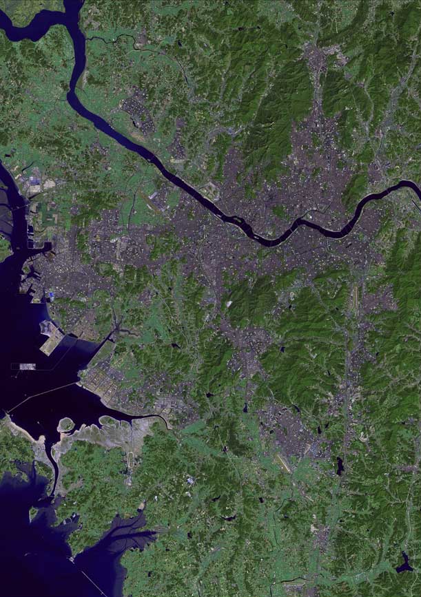
ไฟล, seoul, satellite, ไฟล, ประว, ไฟล, หน, าท, ภาพน, การใช, ไฟล, วนกลาง, อม, ลเก, ยวก, บภาพขนาดของต, วอย, างน, กเซล, ความละเอ, ยดอ, กเซล, กเซล, ภาพท, ความละเอ, ยดส, งกว, 8206, กเซล, ขนาดไฟล, โลไบต, ชน, ดไมม, image, jpeg, ปภาพหร, อไฟล, เส, ยงน, นฉบ, บอย, คอมมอน. ifl prawtiifl hnathimiphaphni karichiflswnklang khxmulekiywkbphaphkhnadkhxngtwxyangni 422 599 phikesl khwamlaexiydxun 169 240 phikesl 611 867 phikesl duphaphthimikhwamlaexiydsungkwa 8206 611 867 phikesl khnadifl 98 kiolibt chnidimm image jpeg rupphaphhruxiflesiyngni tnchbbxyuthi khxmmxns raylaexiyddanlang epnkhxkhwamthiaesdngphlcak ifltnchbbinkhxmmxns khxmmxnsepnewbistinokhrngkarsahrbekbrwbrwmsuxesri thi khunsamarthchwyid khaxthibaySeoul satellite map jpg The raw satellite imagery shown in these images was obtain from NASA and or the US Geological Survey Post processing and production by http www terraprints com wnthi 25 tulakhm ph s 2549 aehlngthima http www terraprints com phusrangsrrkh http www terraprints com iflnixyuphayitsyyaxnuyatkhriexthifkhxmmxns runaesdngthima 2 5 thwipkhunsamarth thicaaebngpn thicathasaena aeckcay aelasngngandngklawtxip thicaeriyberiyngihm thicaddaeplngngandngklaw phayitenguxnikhtxipni aesdngthima khuntxngihekiyrtiecakhxngnganxyangehmaasm odyephimlingkipyngsyyaxnuyat aelarabuhakmikarepliynaeplng khunxacthaechnniidinrupaebbidkidtamkhwr aettxngimichinlksnathiaenawaphuihxnuyatsnbsnunkhunhruxkarichngankhxngkhunhttps creativecommons org licenses by 2 5 CC BY 2 5 Creative Commons Attribution 2 5 true true nbsp khxkhwamxnuyatcakecakhxnglikhsiththiihichnganphaphhruxsuxni idrbkartrwcsxbaelw aelathukekbiwinxasasmkhrtxbklbxieml VRT odysahrbphuichthimibychi VRT samarthtrwcsxbbnthukekiywkbkhxkhwamxnuyatnnid inbnthukhmayelkh 2006110810005047 hakthantxngkarnaphaphhruxsuxniipichthixunnxkehnuxcakinmulnithiwikimiediy krunaxankhxmulekiywkbkarnaenuxhaipichnxkmulnithiwikimiediythihnani thngnihakthanprasngkhcakhxkhayunynekiywkbkarxnuyatihichichphaphhruxsuxni krunatidtxphuichthimibychi VRT hruxaecngphanhnaaecng VRT lingkkhxngbnthuk https ticket wikimedia org otrs index pl Action AgentTicketZoom amp TicketNumber 2006110810005047 Find other files from the same ticket khabrryayodyyxithyephimkhabrryaythrrthdediywephuxkhyaykhwamwaiflnimixairxngkvsHan RiverixethmthiaesdngxyuiniflniprakxbdwysthanalikhsiththimilikhsiththisyyaxnuyatCreative Commons Attribution 2 5 Generic nbsp xngkvsWikimedia VRTS ticket number nbsp xngkvs2006110810005047wnthisrang wnkxtng25 tulakhm 2006 prawtiifl khlikwnthi ewlaephuxduiflthipraktinkhnann wnthi ewlarupyxkhnadphuichkhwamehn pccubn05 57 6 kumphaphnth 2554611 867 98 kiolibt Ras67losslessly cropped with Jpegcrop 01 48 26 tulakhm 2549738 1 100 114 kiolibt Terraprints Information Description The raw satellite imagery shown in these images was obtain from NASA and or the US Geological Survey Post processing and production by http www terraprints com Source http www terraprints com Date 20061025 Author http hnathimiphaphni hnatxipni oyngmathiphaphni aemnahn praethsekahli karichiflswnklang wikixuntxipniichiflni karichbn el wikipedia org Potamos Xan Korea karichbn en wikipedia org Han River Korea Hangang Bridge bombing karichbn hr wikipedia org Han rijeka u Koreji karichbn hy wikipedia org Հանգան karichbn ka wikipedia org ჰანგანი მდინარე karichbn my wikipedia org ဟန မ စ karichbn nl wikipedia org Han Gang karichbn ps wikipedia org هان سیند karichbn ru wikipedia org Hangan karichbn uk wikipedia org Han basejn Zhovtogo morya khxmulekiywkbphaph phaphnimikhxmulephimetim sungswnihymacakklxngdicitxlhruxsaeknenxrthisamarthekbkhxmuldngklawiwrwmkbphaphid thaphaphnithukprbprungaekikhhruxepliynaeplngcakedim khxmulbangxyangcayngkhngimepliynaeplngehmuxnphaphthithukprbprungaekikhnn error0 ekhathungcak https th wikipedia org wiki ifl Seoul satellite map jpg, wikipedia, วิกิ หนังสือ, หนังสือ, ห้องสมุด,