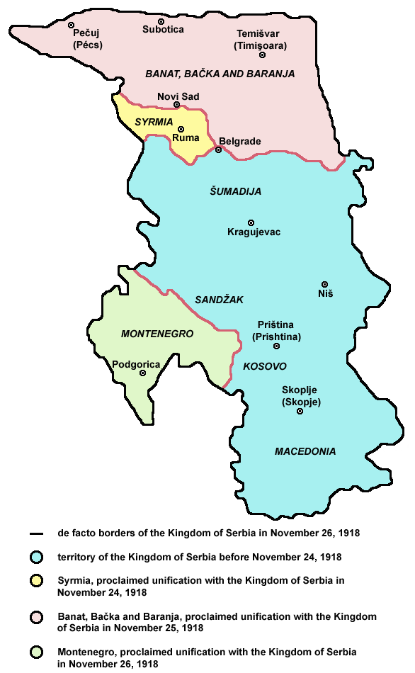
English: de facto borders of the Kingdom of Serbia in November 26, 1918, after unification with Syrmia (November 24), Banat, Bačka and Baranja (November 25) and Montenegro (November 26), during the process of Creation of Yugoslavia.
Serbian: фактичке границе Краљевине Србије 26. новембра 1918. године, после уједињења са Сремом (24. новембра), Банатом, Бачком и Барањом (25. новембра) и Црном Гором (26. новембра), током процеса стварања Југославије.
References
Published references:
Drago Njegovan, Prisajedinjenje Vojvodine Srbiji, Novi Sad, 2004.
Drago Njegovan, Prisajedinjenje Srema, Banata, Bačke i Baranje Srbiji 1918. - dokumenti i prilozi, Novi Sad, 2001.
Lazo M. Kostić, Srpska Vojvodina i njene manjine, Novi Sad, 1999.
Dimitrije Boarov, Politička istorija Vojvodine, Novi Sad, 2001.
Rade Šumonja, Spomenica oslobođenja Sombora 1918-1998, Sombor, 1998.
Internet references:
Map
Map
Map
การอนุญาตใช้สิทธิ
This map has been uploaded by Electionworld from en.wikipedia.org to enable the Wikimedia Atlas of the World . Original uploader to en.wikipedia.org was PANONIAN, known as PANONIAN at en.wikipedia.org. Electionworld is not the creator of this map. Licensing information is below.
Convenția militară de la Belgrad din 13 noiembrie 1918
Stampa:22 shkurt
Mbretëria e Serbisë
Användare:Cledrupide/sandlåda
Подгорицька скупщина
มกราคม 24, 2023
ไฟล, serbia1918, ไฟล, ประว, ไฟล, หน, าท, ภาพน, การใช, ไฟล, วนกลางขนาดของต, วอย, างน, กเซล, ความละเอ, ยดอ, กเซล, กเซล, ภาพท, ความละเอ, ยดส, งกว, 8206, กเซล, ขนาดไฟล, โลไบต, ชน, ดไมม, image, ปภาพหร, อไฟล, เส, ยงน, นฉบ, บอย, คอมมอนส, รายละเอ, ยดด, านล, าง, เป, นข. ifl prawtiifl hnathimiphaphni karichiflswnklangkhnadkhxngtwxyangni 370 600 phikesl khwamlaexiydxun 148 240 phikesl 586 950 phikesl duphaphthimikhwamlaexiydsungkwa 8206 586 950 phikesl khnadifl 60 kiolibt chnidimm image png rupphaphhruxiflesiyngni tnchbbxyuthi khxmmxns raylaexiyddanlang epnkhxkhwamthiaesdngphlcak ifltnchbbinkhxmmxns khxmmxnsepnewbistinokhrngkarsahrbekbrwbrwmsuxesri thi khunsamarthchwyid khwamyx English de facto borders of the Kingdom of Serbia in November 26 1918 after unification with Syrmia November 24 Banat Backa and Baranja November 25 and Montenegro November 26 during the process of Creation of Yugoslavia Serbian faktichke granice Kraљevine Srbiјe 26 novembra 1918 godine posle uјediњeњa sa Sremom 24 novembra Banatom Bachkom i Baraњom 25 novembra i Crnom Gorom 26 novembra tokom procesa stvaraњa Јugoslaviјe References Published references Drago Njegovan Prisajedinjenje Vojvodine Srbiji Novi Sad 2004 Drago Njegovan Prisajedinjenje Srema Banata Backe i Baranje Srbiji 1918 dokumenti i prilozi Novi Sad 2001 Lazo M Kostic Srpska Vojvodina i njene manjine Novi Sad 1999 Dimitrije Boarov Politicka istorija Vojvodine Novi Sad 2001 Dr Tomislav Bogavac Nestajanje Srba Nis 1994 Cedomir Popov Jelena Popov Autonomija Vojvodine srpsko pitanje Sremski Karlovci 2000 Rade Sumonja Spomenica oslobođenja Sombora 1918 1998 Sombor 1998 Internet references Map Map Mapkarxnuyatichsiththi This map has been uploaded by Electionworld from en wikipedia org to enable the Wikimedia Atlas of the World Original uploader to en wikipedia org was PANONIAN known as PANONIAN at en wikipedia org Electionworld is not the creator of this map Licensing information is below Self made map by PANONIAN Public domain Public domain false falsenganniidthukephyaephrsusatharnsmbtiodyecakhxng PANONIAN sungmiphlthwolkinbangpraeths karkrathadngklawxacimsamarththaidtamkdhmayPANONIAN xnuyatihthukkhnmisiththiinkarichiflniinthukehtuphlkarich odyimmimienguxnikh ewnaetkdhmayimxnuyatihthaechnnnkhabrryayodyyxithyephimkhabrryaythrrthdediywephuxkhyaykhwamwaiflnimixairixethmthiaesdngxyuiniflniprakxbdwysthanalikhsiththicopyrighted dedicated to the public domain by copyright holder xngkvssyyaxnuyatreleased into the public domain by the copyright holder xngkvs prawtiifl khlikwnthi ewlaephuxduiflthipraktinkhnann wnthi ewlarupyxkhnadphuichkhwamehn pccubn16 48 24 thnwakhm 2552586 950 60 kiolibt PANONIANaesthetics 03 01 9 krkdakhm 2552586 950 60 kiolibt PANONIAN 20 49 6 krkdakhm 2552586 950 60 kiolibt PANONIAN 19 01 6 krkdakhm 2552586 936 56 kiolibt PANONIAN 04 13 1 knyayn 2550586 936 52 kiolibt PANONIAN 19 08 16 krkdakhm 2550640 826 16 kiolibt Nihad HamzicGreatly reduced image size by losslessly reducing color domain 02 13 9 krkdakhm 2550640 826 42 kiolibt PANONIAN 04 38 22 thnwakhm 2549665 1 050 102 kiolibt Electionworld ew en PANONIAN Self made map by PANONIAN PD user PANONIAN Category Maps of Serbia hnathimiphaphni hnatxipni oyngmathiphaphni rachxanackresxrebiy karichiflswnklang wikixuntxipniichiflni karichbn azb wikipedia org صربیستان شاهلیغی karichbn cs wikipedia org Srbske kralovstvi karichbn el wikipedia org Basileio ths Serbias karichbn en wikipedia org Greater Serbia Kingdom of Serbia Serbs in Vojvodina User talk Marinko Archive 1 User talk CrnaGora Archive5 Creation of Yugoslavia User XcepticZP Todo User Falcaorib Talk Kingdom of Serbia Archive 1 karichbn et wikipedia org Serbia Kuningriik karichbn fa wikipedia org پادشاهی صربستان تشکیل یوگسلاوی karichbn fr wikipedia org Royaume de Serbie karichbn gl wikipedia org Reino de Serbia karichbn he wikipedia org החזית המקדונית במלחמת העולם הראשונה karichbn hr wikipedia org Srbija karichbn nl wikipedia org Koninkrijk Servie 1882 1918 karichbn pnb wikipedia org مملکت سربیا karichbn pt wikipedia org Reino da Servia karichbn ro wikipedia org Regatul Serbiei Convenția militară de la Belgrad din 13 noiembrie 1918 karichbn sk wikipedia org Srbske kraľovstvo karichbn sq wikipedia org Wikipedia Stampat e datave Shkurt Stampa 22 shkurt Mbreteria e Serbise karichbn sv wikipedia org Kungariket Serbien Anvandare Cledrupide sandlada karichbn tr wikipedia org Sirbistan Kralligi karichbn uk wikipedia org Korolivstvo Serbiya Podgoricka skupshina karichbn ur wikipedia org مملکت سربیا karichbn zh wikipedia org 塞尔维亚王国 近代 ekhathungcak https th wikipedia org wiki ifl Serbia1918 png, wikipedia, วิกิ หนังสือ, หนังสือ, ห้องสมุด,