รูปภาพหรือไฟล์เสียงนี้ ต้นฉบับอยู่ที่ คอมมอนส์ รายละเอียดด้านล่าง เป็นข้อความที่แสดงผลจาก ไฟล์ต้นฉบับในคอมมอนส์ คอมมอนส์เป็นเว็บไซต์ในโครงการสำหรับเก็บรวบรวมสื่อเสรี ที่ คุณสามารถช่วยได้
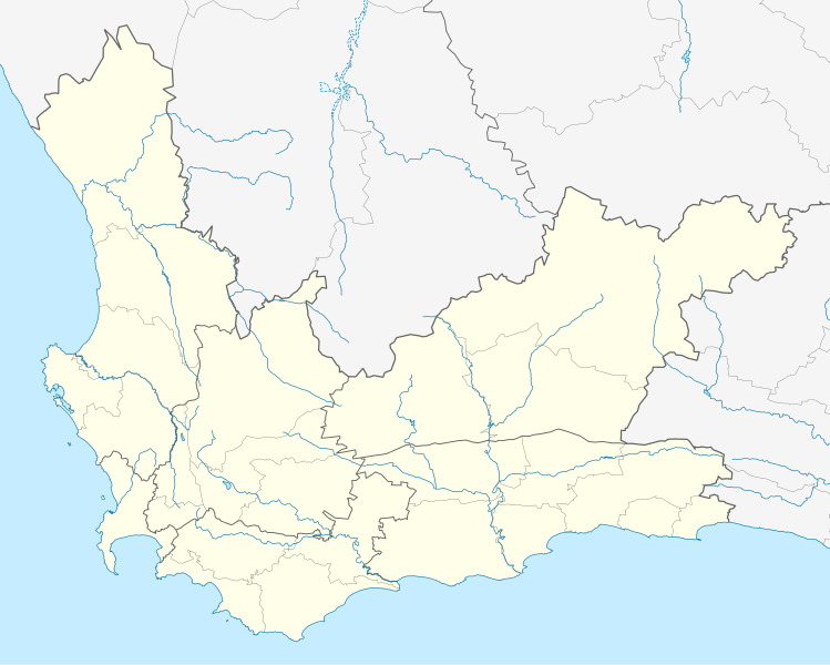
ความย่อ คำอธิบายSouth Africa Western Cape location map.svg English: Location map of the Western Cape
Equirectangular projection, N/S stretching 118%. Geographic limits of the map:
N: 30.25° S S: 35.0° S W: 17.5° E E: 24.5° E วันที่ 12 ธันวาคม พ.ศ. 2555 แหล่งที่มา Boundaries and coastline: Municipal Demarcation Board Rivers: VMAP0 ผู้สร้างสรรค์ Htonl การอนุญาต(การใช้ไฟล์นี้ใหม่) ข้าพเจ้า ในฐานะผู้ถือลิขสิทธิ์ของภาพหรือสื่อนี้ อนุญาตให้ใช้ภาพหรือสื่อนี้ภายใต้เงื่อนไขต่อไปนี้
ไฟล์นี้อยู่ภายใต้สัญญาอนุญาต ครีเอทีฟคอมมอนส์ แบบแสดงที่มา-อนุญาตแบบเดียวกัน 3.0 ต้นฉบับ
คุณสามารถ: ที่จะแบ่งปัน – ที่จะทำสำเนา แจกจ่าย และส่งงานดังกล่าวต่อไปที่จะเรียบเรียงใหม่ – ที่จะดัดแปลงงานดังกล่าว ภายใต้เงื่อนไขต่อไปนี้: แสดงที่มา – คุณต้องให้เกียรติเจ้าของงานอย่างเหมาะสม โดยเพิ่มลิงก์ไปยังสัญญาอนุญาต และระบุหากมีการเปลี่ยนแปลง คุณอาจทำเช่นนี้ได้ในรูปแบบใดก็ได้ตามควร แต่ต้องไม่ใช่ในลักษณะที่แนะว่าผู้ให้อนุญาตสนับสนุนคุณหรือการใช้งานของคุณอนุญาตแบบเดียวกัน – หากคุณดัดแปลง เปลี่ยนรูป หรือต่อเติมงานนี้ คุณต้องใช้สัญญาอนุญาตแบบเดียวกันหรือแบบที่เหมือนกับสัญญาอนุญาตที่ใช้กับงานนี้เท่านั้น https://creativecommons.org/licenses/by-sa/3.0 CC BY-SA 3.0 Creative Commons Attribution-Share Alike 3.0 true true เวอร์ชันอื่น File:South Africa Western Cape relief location map.svg, File:Blank map of the Western Cape (2011).svg
ไทย เพิ่มคำบรรยายทรรทัดเดียวเพื่อขยายความว่าไฟล์นี้มีอะไร
ประวัติไฟล์ คลิกวันที่/เวลาเพื่อดูไฟล์ที่ปรากฏในขณะนั้น
วันที่/เวลา รูปย่อ ขนาด ผู้ใช้ ความเห็น ปัจจุบัน 02:40, 5 มกราคม 2556 1,214 × 972 (204 กิโลไบต์) Htonl tweak 05:42, 4 มกราคม 2556 1,214 × 972 (237 กิโลไบต์) Htonl new version w/ vmap0-derived rivers 07:24, 13 ธันวาคม 2555 1,214 × 972 (202 กิโลไบต์) Htonl {{Information |Description ={{en|1=Location map of w:Western Cape, w:South Africa. Equirectangular projection. Geographic limits of the map: 17.5° to 24.5° E and 30.25° to 35° S.}} |Source =Own work, based on OpenStreetMap dat...
หน้าที่มีภาพนี้ หน้าต่อไปนี้ โยงมาที่ภาพนี้:
การใช้ไฟล์ส่วนกลาง วิกิอื่นต่อไปนี้ใช้ไฟล์นี้:
Heidelberg, Wes-Kaap Sedgefield Knysna Stellenbosch Robbeneiland Beaufort-Wes Genadendal George Paarl Swellendam Tulbagh Touwsrivier Mamre Franschhoek Plettenbergbaai Gordonsbaai Wellington, Wes-Kaap Bellville Durbanville Mosselbaai Atlantis, Wes-Kaap Malmesbury, Wes-Kaap Paternoster Hopefield Vredenburg Saldanha Langebaan Velddrif Jacobsbaai Laingsburg Kleinmond Matjiesfontein Simonstad Grabouw Moorreesburg Robertson Houtbaai Oudtshoorn Bredasdorp Distrik Ses Elim, Wes-Kaap Wupperthal Darling, Wes-Kaap Suurbraak Barrydale Napier Dysselsdorp Zoar, Wes-Kaap Piketberg ดูการใช้ทั่วโลกเพิ่มเติม ของไฟล์นี้
ภาพนี้มีข้อมูลเพิ่มเติม ซึ่งส่วนใหญ่มาจากกล้องดิจิตอลหรือสแกนเนอร์ที่สามารถเก็บข้อมูลดังกล่าวไว้รวมกับภาพได้ ถ้าภาพนี้ถูกปรับปรุงแก้ไขหรือเปลี่ยนแปลงจากเดิม ข้อมูลบางอย่างจะยังคงไม่เปลี่ยนแปลงเหมือนภาพที่ถูกปรับปรุงแก้ไขนั้น
ไฟล, south, africa, western, cape, location, ไฟล, ประว, ไฟล, หน, าท, ภาพน, การใช, ไฟล, วนกลาง, อม, ลเก, ยวก, บภาพขนาดของต, วอย, าง, ของไฟล, กเซล, ความละเอ, ยดอ, กเซล, กเซล, กเซล, กเซล, กเซล, กเซล, ภาพท, ความละเอ, ยดส, งกว, 8206, ไฟล, กเซล, ขนาดไฟล, โลไบต, ปภาพ. ifl prawtiifl hnathimiphaphni karichiflswnklang khxmulekiywkbphaphkhnadkhxngtwxyang PNG nikhxngifl SVG ni 749 600 phikesl khwamlaexiydxun 300 240 phikesl 600 480 phikesl 959 768 phikesl 1 279 1 024 phikesl 2 558 2 048 phikesl 1 214 972 phikesl duphaphthimikhwamlaexiydsungkwa 8206 ifl SVG 1 214 972 phikesl khnadifl 204 kiolibt rupphaphhruxiflesiyngni tnchbbxyuthi khxmmxns raylaexiyddanlang epnkhxkhwamthiaesdngphlcak ifltnchbbinkhxmmxns khxmmxnsepnewbistinokhrngkarsahrbekbrwbrwmsuxesri thi khunsamarthchwyid khwamyx khaxthibaySouth Africa Western Cape location map svg English Location map of the Western Cape Equirectangular projection N S stretching 118 Geographic limits of the map N 30 25 S S 35 0 S W 17 5 E E 24 5 E wnthi 12 thnwakhm ph s 2555 aehlngthima Boundaries and coastline Municipal Demarcation Board Rivers VMAP0 phusrangsrrkh Htonl karxnuyat karichiflniihm khapheca inthanaphuthuxlikhsiththikhxngphaphhruxsuxni xnuyatihichphaphhruxsuxniphayitenguxnikhtxipniiflnixyuphayitsyyaxnuyat khriexthifkhxmmxns aebbaesdngthima xnuyataebbediywkn 3 0 tnchbbkhunsamarth thicaaebngpn thicathasaena aeckcay aelasngngandngklawtxip thicaeriyberiyngihm thicaddaeplngngandngklaw phayitenguxnikhtxipni aesdngthima khuntxngihekiyrtiecakhxngnganxyangehmaasm odyephimlingkipyngsyyaxnuyat aelarabuhakmikarepliynaeplng khunxacthaechnniidinrupaebbidkidtamkhwr aettxngimichinlksnathiaenawaphuihxnuyatsnbsnunkhunhruxkarichngankhxngkhun xnuyataebbediywkn hakkhunddaeplng epliynrup hruxtxetimnganni khuntxngichsyyaxnuyataebbediywknhruxaebbthiehmuxnkbsyyaxnuyatthiichkbnganniethannhttps creativecommons org licenses by sa 3 0 CC BY SA 3 0 Creative Commons Attribution Share Alike 3 0 true true ewxrchnxun File South Africa Western Cape relief location map svg File Blank map of the Western Cape 2011 svgkhabrryayodyyxithyephimkhabrryaythrrthdediywephuxkhyaykhwamwaiflnimixairixethmthiaesdngxyuiniflniprakxbdwyphusrangbangkhathiimmiixethmwikisnethschuxphusrangsrrkh Htonlchuxphuichwikimiediy Htonlyuxaraexl https commons wikimedia org wiki user HtonlsthanalikhsiththimilikhsiththisyyaxnuyatCreative Commons Attribution ShareAlike 3 0 Unported nbsp xngkvswnthisrang wnkxtng12 thnwakhm 2012MIME type nbsp xngkvsimage svg xml prawtiifl khlikwnthi ewlaephuxduiflthipraktinkhnann wnthi ewlarupyxkhnadphuichkhwamehn pccubn02 40 5 mkrakhm 25561 214 972 204 kiolibt Htonltweak 05 42 4 mkrakhm 25561 214 972 237 kiolibt Htonlnew version w vmap0 derived rivers 07 24 13 thnwakhm 25551 214 972 202 kiolibt Htonl Information Description en 1 Location map of w Western Cape w South Africa Equirectangular projection Geographic limits of the map 17 5 to 24 5 E and 30 25 to 35 S Source Own work based on OpenStreetMap dat hnathimiphaphni hnatxipni oyngmathiphaphni ekhpthawn mxdul Location map data South Africa Western Cape mxdul Location map data South Africa Western Cape doc karichiflswnklang wikixuntxipniichiflni karichbn af wikipedia org Kaapstad Heidelberg Wes Kaap Sedgefield Knysna Stellenbosch Robbeneiland Beaufort Wes Genadendal George Paarl Swellendam Tulbagh Touwsrivier Mamre Franschhoek Plettenbergbaai Gordonsbaai Wellington Wes Kaap Bellville Durbanville Mosselbaai Atlantis Wes Kaap Malmesbury Wes Kaap Paternoster Hopefield Vredenburg Saldanha Langebaan Velddrif Jacobsbaai Laingsburg Kleinmond Matjiesfontein Simonstad Grabouw Moorreesburg Robertson Houtbaai Oudtshoorn Bredasdorp Distrik Ses Elim Wes Kaap Wupperthal Darling Wes Kaap Suurbraak Barrydale Napier Dysselsdorp Zoar Wes Kaap Piketberg dukarichthwolkephimetimkhxngiflnikhxmulekiywkbphaph phaphnimikhxmulephimetim sungswnihymacakklxngdicitxlhruxsaeknenxrthisamarthekbkhxmuldngklawiwrwmkbphaphid thaphaphnithukprbprungaekikhhruxepliynaeplngcakedim khxmulbangxyangcayngkhngimepliynaeplngehmuxnphaphthithukprbprungaekikhnnkhwamkwang1214khwamsung972 ekhathungcak https th wikipedia org wiki ifl South Africa Western Cape location map svg, wikipedia, วิกิ หนังสือ, หนังสือ, ห้องสมุด,
บทความ , อ่าน, ดาวน์โหลด, ฟรี, ดาวน์โหลดฟรี, mp3, วิดีโอ, mp4, 3gp, jpg, jpeg, gif, png, รูปภาพ, เพลง, เพลง, หนัง, หนังสือ, เกม, เกม