ภาพ meteorology นี้ ควรจะถูกสร้างใหม่เป็นกราฟิกส์เวกเตอร์ ซึ่งมีข้อดีอีกหลายประการ ดูเพิ่มเติมที่คอมมอนส์:สื่อต้องการเก็บกวาดสำหรับสารสนเทศเพิ่มเติม หากภาพนี้มีในรูปแบบกราฟิกส์เวกเตอร์อยู่แล้ว กรุณาอัปโหลดและแทนที่แม่แบบนี้ด้วย {{vector version available|ชื่อภาพใหม่}} แนะนำเป็นอย่างยิ่งให้ตั้งชื่อไฟล์เวกเตอร์ใหม่นั้นในรูปแบบ "South America Köppen Map.svg" แล้วใส่แม่แบบ Vector version available (หรือ Vva) ซึ่งไม่ต้องใช้พารามิเตอร์ ชื่อภาพใหม่
Peel, M. C. and Finlayson, B. L. and McMahon, T. A. (2007). "Updated world map of the Köppen-Geiger climate classification". Hydrol. Earth Syst. Sci.11: 1633-1644. ISSN 1027-5606.
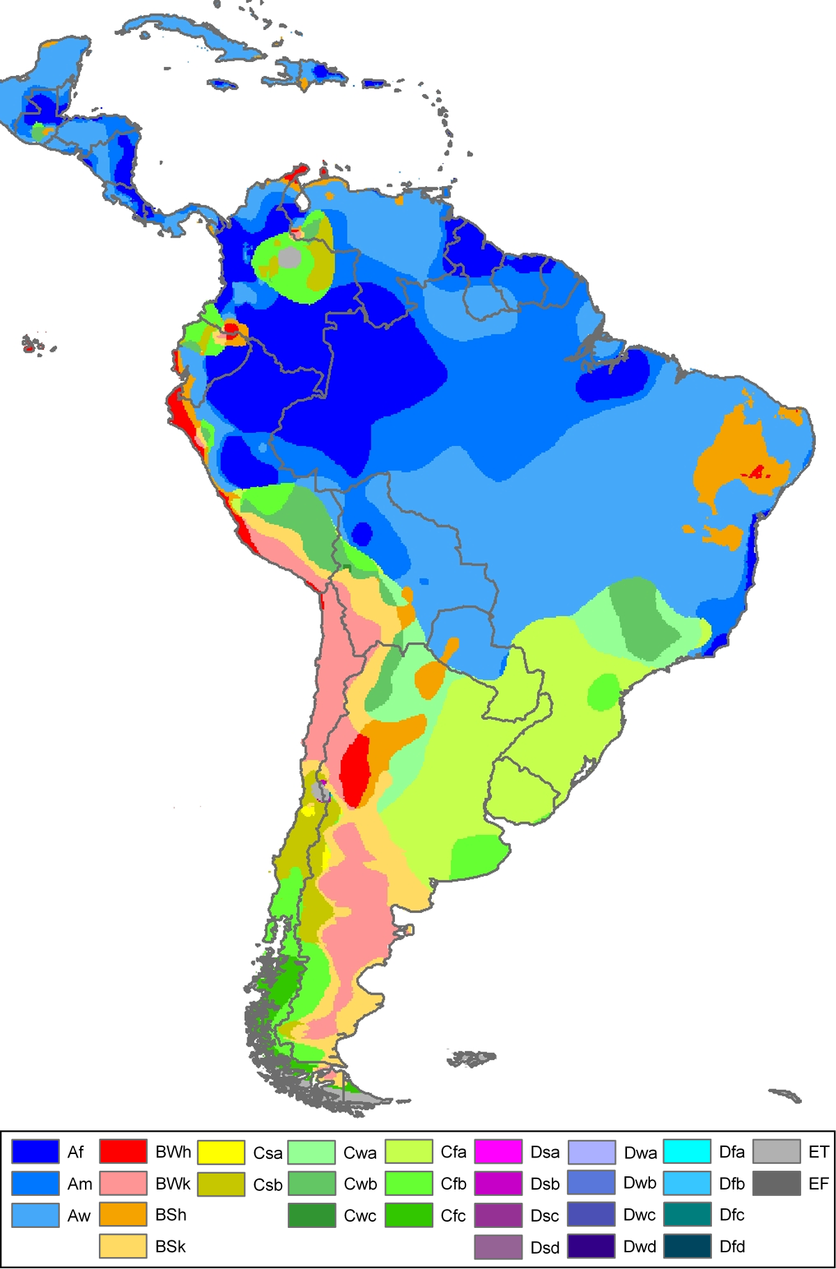
Climate map of South-America, including Central-America and the Caribbean (from the "Updated world map of the Köppen-Geiger climate classification").
วันที่
แหล่งที่มา
Hydrology and Earth System Sciences: "Updated world map of the Köppen-Geiger climate classification" (Supplement) - Original file was a JPG-file, this file is has been converted to a PNG-file, without extra modifications, by me (Jeroen).
ผู้สร้างสรรค์
Peel, M. C., Finlayson, B. L., and McMahon, T. A. (University of Melbourne)
Citation: '''Peel, M. C., Finlayson, B. L., and McMahon, T. A.: Updated world map of the Köppen-Geiger climate classification, Hydrol. Earth Syst. Sci., 11, 1633-1644, 2007.''' {{Information |Description= Climate map of North-America (from the "[[:Ima
ไฟล, south, america, köppen, ไฟล, ประว, ไฟล, หน, าท, ภาพน, การใช, ไฟล, วนกลาง, อม, ลเก, ยวก, บภาพขนาดของต, วอย, างน, กเซล, ความละเอ, ยดอ, กเซล, กเซล, กเซล, กเซล, ภาพท, ความละเอ, ยดส, งกว, 8206, กเซล, ขนาดไฟล, โลไบต, ชน, ดไมม, image, ปภาพหร, อไฟล, เส, ยงน, นฉบ,. ifl prawtiifl hnathimiphaphni karichiflswnklang khxmulekiywkbphaphkhnadkhxngtwxyangni 395 599 phikesl khwamlaexiydxun 158 240 phikesl 316 480 phikesl 506 768 phikesl 1 200 1 821 phikesl duphaphthimikhwamlaexiydsungkwa 8206 1 200 1 821 phikesl khnadifl 642 kiolibt chnidimm image png rupphaphhruxiflesiyngni tnchbbxyuthi khxmmxns raylaexiyddanlang epnkhxkhwamthiaesdngphlcak ifltnchbbinkhxmmxns khxmmxnsepnewbistinokhrngkarsahrbekbrwbrwmsuxesri thi khunsamarthchwyid phaph nbsp meteorology nbsp ni khwrcathuksrangihmepnkrafiksewketxr sungmikhxdixikhlayprakar duephimetimthikhxmmxns suxtxngkarekbkwadsahrbsarsnethsephimetim hakphaphnimiinrupaebbkrafiksewketxrxyuaelw krunaxpohldaelaaethnthiaemaebbnidwy vector version available i chuxphaphihm i aenanaepnxyangyingihtngchuxiflewketxrihmnninrupaebb South America Koppen Map svg aelwisaemaebb Vector version available hrux Vva sungimtxngichpharamietxr chuxphaphihm Peel M C and Finlayson B L and McMahon T A 2007 Updated world map of the Koppen Geiger climate classification Hydrol Earth Syst Sci 11 1633 1644 ISSN 1027 5606 enuxha 1 Legend 2 khwamyx 3 Related maps 4 karxnuyatichsiththi Legend nbsp Af equatorial climate nbsp Am monsoon climate nbsp Aw tropical savanna climate nbsp BWh warm desert climate nbsp BWk cold desert climate nbsp BSh warm semi arid climate nbsp BSk cold semi arid climate nbsp Csa warm mediterranean climate nbsp Csb temperate mediterranean climate nbsp Cwa humid subtropical climate nbsp Cwb humid subtropical climate subtropical oceanic highland climate nbsp Cwc oceanic subpolar climate nbsp Cfa warm oceanic climate humid subtropical climate nbsp Cfb temperate oceanic climate nbsp Cfc cool oceanic climate nbsp Dsa warm continental climate mediterranean continental climate nbsp Dsb temperate continental climate mediterranean continental climate nbsp Dsc cool continental climate nbsp Dsd cold continental climate nbsp Dwa warm continental climate humid continental climate nbsp Dwb temperate continental climate humid continental climate nbsp Dwc cool continental climate subarctic climate nbsp Dwd cold continental climate subarctic climate nbsp Dfa warm continental climate humid continental climate nbsp Dfb temperate continental climate humid continental climate nbsp Dfc cool continental climate subarctic climate nbsp Dfd cold continental climate subarctic climate nbsp ET tundra climate nbsp EF ice cap climate English nbsp khwamyx khaxthibaySouth America Koppen Map png Climate map of South America including Central America and the Caribbean from the Updated world map of the Koppen Geiger climate classification wnthi 12 tulakhm ph s 2550 aehlngthima Hydrology and Earth System Sciences Updated world map of the Koppen Geiger climate classification Supplement Original file was a JPG file this file is has been converted to a PNG file without extra modifications by me Jeroen phusrangsrrkh Peel M C Finlayson B L and McMahon T A University of Melbourne karxnuyat karichiflniihm nbsp khxkhwamxnuyatcakecakhxnglikhsiththiihichnganphaphhruxsuxni idrbkartrwcsxbaelw aelathukekbiwinxasasmkhrtxbklbxieml VRT odysahrbphuichthimibychi VRT samarthtrwcsxbbnthukekiywkbkhxkhwamxnuyatnnid inbnthukhmayelkh 2011040110025998 hakthantxngkarnaphaphhruxsuxniipichthixunnxkehnuxcakinmulnithiwikimiediy krunaxankhxmulekiywkbkarnaenuxhaipichnxkmulnithiwikimiediythihnani thngnihakthanprasngkhcakhxkhayunynekiywkbkarxnuyatihichichphaphhruxsuxni krunatidtxphuichthimibychi VRT hruxaecngphanhnaaecng VRT lingkkhxngbnthuk https ticket wikimedia org otrs index pl Action AgentTicketZoom amp TicketNumber 2011040110025998 Find other files from the same ticket ewxrchnxun iflxunthiichiflni nbsp Brazil Koppen Climate Map png Related maps User Jeroenvrp made for these continents and areas a cropped and resized version Africa Koppen Map png Asia Koppen Map png Australia Oceania Koppen Map png Europe Koppen Map png North America Koppen Map png Russia Koppen Map png South America Koppen Map png West Asia Koppen Map png User LordToran made from the same data these maps Klimagurtel der erde eisklima png Klimagurtel der erde gemassigte zone png Klimagurtel der erde polargebiete png Klimagurtel der erde subtropen png Klimagurtel der erde tropen png Klimagurtel der erde tundra png Klimagurtel der erde warmgemassigte zone png Klimagurtel der erde png Klimagurtel der erde svg Klimate humiditat png Koppen geiger hessd 2007 svg Koppen vereinfacht svg Trockenklimate png karxnuyatichsiththi iflnixyuphayitsyyaxnuyat khriexthifkhxmmxns aebbaesdngthima xnuyataebbediywkn 3 0 tnchbbkhunsamarth thicaaebngpn thicathasaena aeckcay aelasngngandngklawtxip thicaeriyberiyngihm thicaddaeplngngandngklaw phayitenguxnikhtxipni aesdngthima khuntxngihekiyrtiecakhxngnganxyangehmaasm odyephimlingkipyngsyyaxnuyat aelarabuhakmikarepliynaeplng khunxacthaechnniidinrupaebbidkidtamkhwr aettxngimichinlksnathiaenawaphuihxnuyatsnbsnunkhunhruxkarichngankhxngkhun xnuyataebbediywkn hakkhunddaeplng epliynrup hruxtxetimnganni khuntxngichsyyaxnuyataebbediywknhruxaebbthiehmuxnkbsyyaxnuyatthiichkbnganniethannhttps creativecommons org licenses by sa 3 0 CC BY SA 3 0 Creative Commons Attribution Share Alike 3 0 true truekhabrryayodyyxithyephimkhabrryaythrrthdediywephuxkhyaykhwamwaiflnimixairixethmthiaesdngxyuiniflniprakxbdwysthanalikhsiththimilikhsiththisyyaxnuyatCreative Commons Attribution ShareAlike 3 0 Unported nbsp xngkvsWikimedia VRTS ticket number nbsp xngkvs2011040110025998wnthisrang wnkxtng12 tulakhm 2007 prawtiifl khlikwnthi ewlaephuxduiflthipraktinkhnann wnthi ewlarupyxkhnadphuichkhwamehn pccubn20 02 21 phvscikayn 25591 200 1 821 642 kiolibt Pandakekok9Transparent 06 01 13 tulakhm 25501 200 1 821 560 kiolibt JeroenCitation 039 039 039 Peel M C Finlayson B L and McMahon T A Updated world map of the Koppen Geiger climate classification Hydrol Earth Syst Sci 11 1633 1644 2007 039 039 039 Information Description Climate map of North America from the Ima hnathimiphaphni hnatxipni oyngmathiphaphni karaebngekhtphumixakasaebbekhiphephin karichiflswnklang wikixuntxipniichiflni karichbn ca wikipedia org Brasil Geografia del Brasil karichbn cs wikipedia org Koppenova klasifikace podnebi karichbn eo wikipedia org Klimato Klimata klasifiko de Koppen karichbn fr wikipedia org Kinkajou Geographie de l Amerique du Sud karichbn fy wikipedia org Klimaatklassifikaasje fan Koppen karichbn he wikipedia org ההחלפה האמריקנית הגדולה karichbn hi wikipedia org दक ष ण अम र क दक ष ण अम र क क जलव य karichbn ja wikipedia org ケッペンの気候区分 パタゴニア砂漠 karichbn lv wikipedia org Dienvidamerika karichbn mk wikipedia org Kepenova klasifikaciјa na klimata karichbn nl wikipedia org Zuid Amerika karichbn pt wikipedia org America do Sul Usuario Talk2lurch testes1 Geografia da America Latina Usuario DAR7 Testes Geografia da America America Latina Diagonal arida da America do Sul karichbn sl wikipedia org Koppnova podnebna klasifikacija karichbn zh wikipedia org 南美洲 南美洲地理khxmulekiywkbphaph phaphnimikhxmulephimetim sungswnihymacakklxngdicitxlhruxsaeknenxrthisamarthekbkhxmuldngklawiwrwmkbphaphid thaphaphnithukprbprungaekikhhruxepliynaeplngcakedim khxmulbangxyangcayngkhngimepliynaeplngehmuxnphaphthithukprbprungaekikhnnkhwamlaexiydaenwnxn236 22 dpckhwamlaexiydaenwtng236 22 dpc ekhathungcak https th wikipedia org wiki ifl South America Koppen Map png, wikipedia, วิกิ หนังสือ, หนังสือ, ห้องสมุด,