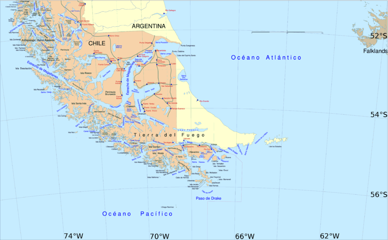
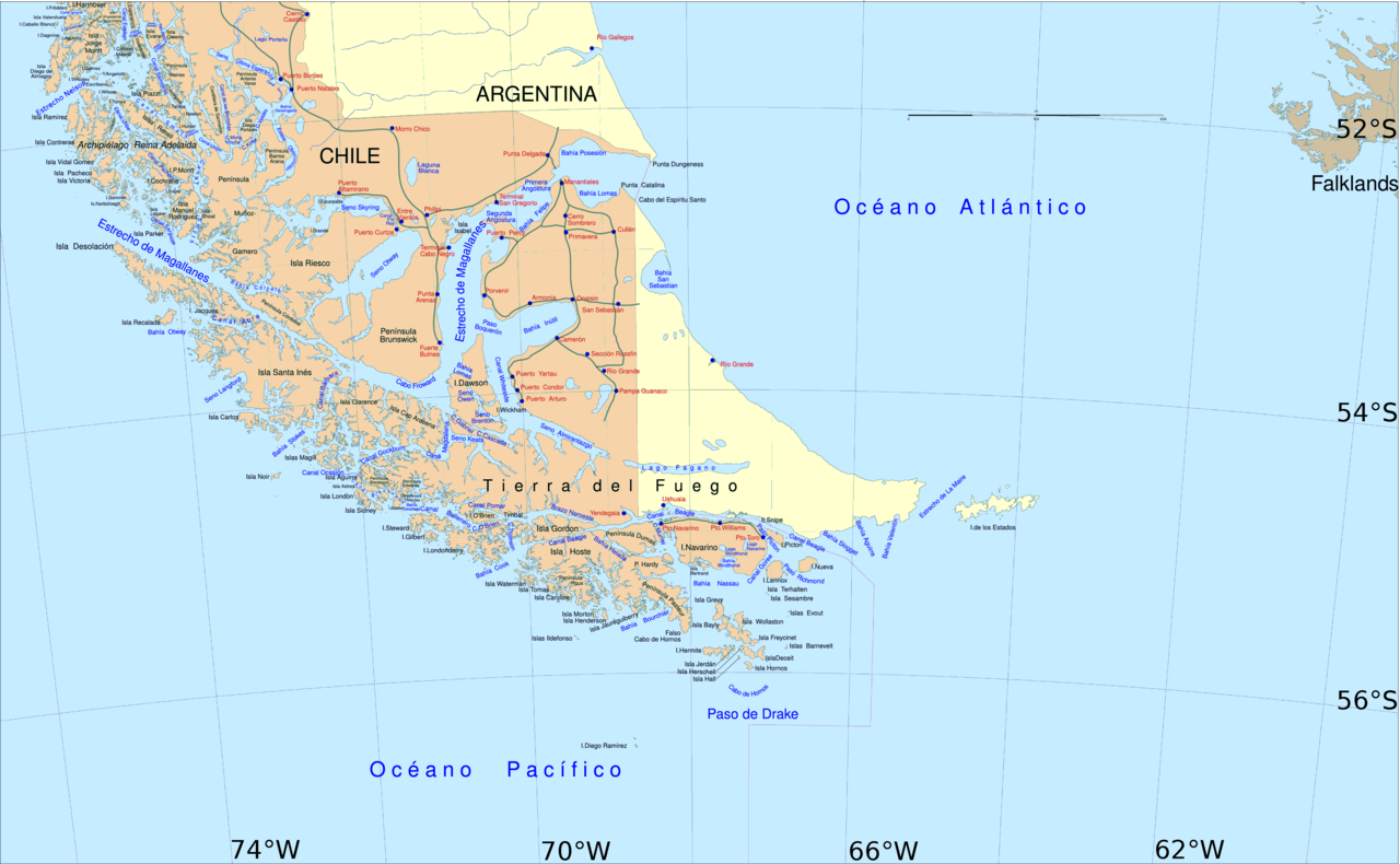
English: Political map of southern Chile and Argentina, from Straits of Magellan to Cape Horn.
Español: Mapa político del sur de Chile y la Argentina, entre el estrecho de Magallanes y el cabo de Hornos.
วันที่
แหล่งที่มา
File:Sur2.gif
ผู้สร้างสรรค์
User:Createaccount
การอนุญาต (การใช้ไฟล์นี้ใหม่)
The map has been created with the Generic Mapping Tools: https://www.generic-mapping-tools.org/ using one or more of these public-domain datasets for the relief:
{{Information |Description={{en|1=political map of southern Chile/Argentina: From Straits of Magellan to Cape Horn}} |Source=File:Sur2.gif |Author=User:Createaccount |Date=2008 |Permission={{GFDL-GMT}}} |other_versions=File:Sur2.gif }} <!--
ไฟล, south, america, southern, ไฟล, ประว, ไฟล, หน, าท, ภาพน, การใช, ไฟล, วนกลาง, อม, ลเก, ยวก, บภาพขนาดของต, วอย, างน, กเซล, ความละเอ, ยดอ, กเซล, กเซล, กเซล, กเซล, กเซล, กเซล, ภาพท, ความละเอ, ยดส, งกว, 8206, กเซล, ขนาดไฟล, โลไบต, ชน, ดไมม, image, ปภาพหร, อไฟล,. ifl prawtiifl hnathimiphaphni karichiflswnklang khxmulekiywkbphaphkhnadkhxngtwxyangni 800 494 phikesl khwamlaexiydxun 320 198 phikesl 640 395 phikesl 1 024 632 phikesl 1 280 790 phikesl 2 560 1 581 phikesl 3 859 2 383 phikesl duphaphthimikhwamlaexiydsungkwa 8206 3 859 2 383 phikesl khnadifl 596 kiolibt chnidimm image png rupphaphhruxiflesiyngni tnchbbxyuthi khxmmxns raylaexiyddanlang epnkhxkhwamthiaesdngphlcak ifltnchbbinkhxmmxns khxmmxnsepnewbistinokhrngkarsahrbekbrwbrwmsuxesri thi khunsamarthchwyid khwamyx khaxthibaySouth America southern tip pol png English Political map of southern Chile and Argentina from Straits of Magellan to Cape Horn Espanol Mapa politico del sur de Chile y la Argentina entre el estrecho de Magallanes y el cabo de Hornos wnthi ph s 2551 aehlngthima File Sur2 gif phusrangsrrkh User Createaccount karxnuyat karichiflniihm The map has been created with the Generic Mapping Tools https www generic mapping tools org using one or more of these public domain datasets for the relief ETOPO2 topography bathymetry http www ngdc noaa gov mgg global global html GLOBE topography http www ngdc noaa gov mgg topo gltiles html SRTM topography http www2 jpl nasa gov srtm ব ল nbsp English nbsp espanol nbsp francais nbsp italiano nbsp 日本語 nbsp makedonski nbsp sicilianu nbsp 中文 简体 nbsp 中文 繁體 nbsp xnuyatihkhdlxk aeckcayaela hruxddaeprexksarniphayitenguxnikhkhxngsyyaxnuyatexksaresrikhxngknu run 1 2 hruxrunid nbcaknithixxkodymulnithisxftaewresri odyimmiswnidhamaekikh immikhxkhwampkhnaaelapkhlng saenakhxngsyyaxnuyatrwmxyuinswnchux syyaxnuyatexksaresrikhxngknuhttp www gnu org copyleft fdl html GFDL GNU Free Documentation License true true ewxrchnxun iflxunthiichiflni nbsp Metula svg karxnuyatichsiththi xnuyatihkhdlxk aeckcayaela hruxddaeprexksarniphayitenguxnikhkhxngsyyaxnuyatexksaresrikhxngknu run 1 2 hruxrunid nbcaknithixxkodymulnithisxftaewresri odyimmiswnidhamaekikh immikhxkhwampkhnaaelapkhlng saenakhxngsyyaxnuyatrwmxyuinswnchux syyaxnuyatexksaresrikhxngknuhttp www gnu org copyleft fdl html GFDL GNU Free Documentation License true true iflnixyuphayitsyyaxnuyat khriexthifkhxmmxns aebbaesdngthima xnuyataebbediywkn 3 0 tnchbb khunsamarth thicaaebngpn thicathasaena aeckcay aelasngngandngklawtxip thicaeriyberiyngihm thicaddaeplngngandngklaw phayitenguxnikhtxipni aesdngthima khuntxngihekiyrtiecakhxngnganxyangehmaasm odyephimlingkipyngsyyaxnuyat aelarabuhakmikarepliynaeplng khunxacthaechnniidinrupaebbidkidtamkhwr aettxngimichinlksnathiaenawaphuihxnuyatsnbsnunkhunhruxkarichngankhxngkhun xnuyataebbediywkn hakkhunddaeplng epliynrup hruxtxetimnganni khuntxngichsyyaxnuyataebbediywknhruxaebbthiehmuxnkbsyyaxnuyatthiichkbnganniethann payaesdngsthanalikhsiththinithukephimephuxihepniptamkarepliynaeplngsyyaxnuyatkhxngmulnithiwikimiediy cak GFDL ipyng GFDL khwbkhukb CC BY SA 3 0 http creativecommons org licenses by sa 3 0 CC BY SA 3 0 Creative Commons Attribution Share Alike 3 0 true truekhabrryayodyyxithyephimkhabrryaythrrthdediywephuxkhyaykhwamwaiflnimixairxngkvsPolitical map of southern Chile and Argentinaixethmthiaesdngxyuiniflniprakxbdwypolitical map nbsp xngkvspraethschilipraethsxarecntinasthanalikhsiththimilikhsiththisyyaxnuyatGNU Free Documentation License version 1 2 or later nbsp xngkvsCreative Commons Attribution ShareAlike 3 0 Unported nbsp xngkvswnthisrang wnkxtng2008 prawtiifl khlikwnthi ewlaephuxduiflthipraktinkhnann wnthi ewlarupyxkhnadphuichkhwamehn pccubn21 06 30 emsayn 25593 859 2 383 596 kiolibt HohumCartographic colours 18 09 3 emsayn 25563 859 2 383 597 kiolibt KeysangerMargin right and top cropped 17 47 3 emsayn 25563 859 2 383 597 kiolibt KeysangerEstrecho Nelson added Bigger Latitude and Longitude within the image empty margin cropped 02 30 4 phvsphakhm 25523 894 2 441 639 kiolibt Pitichinacciodifferent colour 02 29 4 phvsphakhm 25523 894 2 441 639 kiolibt Pitichinaccio Information Description en 1 political map of southern Chile Argentina From Straits of Magellan to Cape Horn Source File Sur2 gif Author User Createaccount Date 2008 Permission GFDL GMT other versions File Sur2 gif lt hnathimiphaphni hnatxipni oyngmathiphaphni khabsmuthrbrnswik aehlmofrewird karichiflswnklang wikixuntxipniichiflni karichbn af wikipedia org Vuurland Straat van Magellaan Isla Grande de Tierra del Fuego karichbn als wikipedia org Feuerland karichbn ar wikipedia org أرض النار محافظة تييرا دل فويغو كيب هورن الخاطىء شبه جزيرة برونزويك karichbn ast wikipedia org Puerto Toro Canal Beagle parte central karichbn br wikipedia org Inizi Hermite Enez Hornos Enezeg Reina Adelaida Enez Londonderry Enez Hoste karichbn ca wikipedia org Canal Magdalena karichbn de wikipedia org Feuerland Magellanstrasse Puerto Williams Beagle Konflikt Beagle Kartographie ab 1881 Operation Soberania Freundschafts und Friedensvertrag von 1984 zwischen Chile und Argentinien Papstliche Vermittlung im Beagle Konflikt Schiedsgericht im Beagle Konflikt Direkte Verhandlungen zwischen Chile und Argentinien 1977 78 Snipe Zwischenfall Wollaston Inseln Munoz Gamero Halbinsel Vorlage Beaglenav Jose Emperaire Isla Desolacion Isla Clarence Isla Capitan Aracena Canal Cockburn Canal Magdalena Magellanstrasse Canal Abra Isla Manuel Rodriguez Isla Parker Scotia Bogen karichbn de wiktionary org Feuerland karichbn en wikipedia org Cape Froward Porvenir Chile Santa Ines Island Puerto Toro False Cape Horn Puerto del Hambre Maritime history of California Brunswick Peninsula Almirantazgo Fjord dukarichthwolkephimetimkhxngiflnikhxmulekiywkbphaph phaphnimikhxmulephimetim sungswnihymacakklxngdicitxlhruxsaeknenxrthisamarthekbkhxmuldngklawiwrwmkbphaphid thaphaphnithukprbprungaekikhhruxepliynaeplngcakedim khxmulbangxyangcayngkhngimepliynaeplngehmuxnphaphthithukprbprungaekikhnnkhwamlaexiydaenwnxn28 35 dpckhwamlaexiydaenwtng28 35 dpcaekikhphaphlasud14 05 30 emsayn 2559 ekhathungcak https th wikipedia org wiki ifl South America southern tip pol png, wikipedia, วิกิ หนังสือ, หนังสือ, ห้องสมุด,