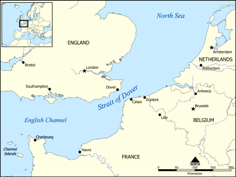
This map shows the location of the Strait of Dover between England and France, and part of the English Channel and the North Sea. It also shows nearby towns such as Dover, Calais, and Dunkirk.
Created by NormanEinstein, December 15, 2005.
วันที่
15 ธันวาคม พ.ศ. 2548 (original upload date)
แหล่งที่มา
No machine-readable source provided. Own work assumed (based on copyright claims).
ผู้สร้างสรรค์
No machine-readable author provided. NormanEinstein assumed (based on copyright claims).
This map shows the location of the Strait of Dover between England and France, and part of the English Channel and the North Sea. It also shows nearby towns such as Dover, Calais, and Dunkirk. Created by NormanEinstein, December 15, 2005. {{GFDL-self}}
ไฟล, strait, dover, ไฟล, ประว, ไฟล, หน, าท, ภาพน, การใช, ไฟล, วนกลาง, อม, ลเก, ยวก, บภาพขนาดของต, วอย, างน, กเซล, ความละเอ, ยดอ, กเซล, กเซล, กเซล, ภาพท, ความละเอ, ยดส, งกว, 8206, กเซล, ขนาดไฟล, โลไบต, ชน, ดไมม, image, ปภาพหร, อไฟล, เส, ยงน, นฉบ, บอย, คอมมอนส, . ifl prawtiifl hnathimiphaphni karichiflswnklang khxmulekiywkbphaphkhnadkhxngtwxyangni 798 599 phikesl khwamlaexiydxun 320 240 phikesl 639 480 phikesl 1 000 751 phikesl duphaphthimikhwamlaexiydsungkwa 8206 1 000 751 phikesl khnadifl 187 kiolibt chnidimm image png rupphaphhruxiflesiyngni tnchbbxyuthi khxmmxns raylaexiyddanlang epnkhxkhwamthiaesdngphlcak ifltnchbbinkhxmmxns khxmmxnsepnewbistinokhrngkarsahrbekbrwbrwmsuxesri thi khunsamarthchwyid khwamyx khaxthibayStrait of Dover map png This map shows the location of the Strait of Dover between England and France and part of the English Channel and the North Sea It also shows nearby towns such as Dover Calais and Dunkirk Created by NormanEinstein December 15 2005 wnthi 15 thnwakhm ph s 2548 original upload date aehlngthima No machine readable source provided Own work assumed based on copyright claims phusrangsrrkh No machine readable author provided NormanEinstein assumed based on copyright claims karxnuyatichsiththi khapheca inthanaphuthuxlikhsiththikhxngphaphhruxsuxni xnuyatihichphaphhruxsuxniphayitenguxnikhtxipni xnuyatihkhdlxk aeckcayaela hruxddaeprexksarniphayitenguxnikhkhxngsyyaxnuyatexksaresrikhxngknu run 1 2 hruxrunid nbcaknithixxkodymulnithisxftaewresri odyimmiswnidhamaekikh immikhxkhwampkhnaaelapkhlng saenakhxngsyyaxnuyatrwmxyuinswnchux syyaxnuyatexksaresrikhxngknuhttp www gnu org copyleft fdl html GFDL GNU Free Documentation License true trueiflnixyuphayitsyyaxnuyat khriexthifkhxmmxns aebbaesdngthima xnuyataebbediywkn 3 0 tnchbbkhunsamarth thicaaebngpn thicathasaena aeckcay aelasngngandngklawtxip thicaeriyberiyngihm thicaddaeplngngandngklaw phayitenguxnikhtxipni aesdngthima khuntxngihekiyrtiecakhxngnganxyangehmaasm odyephimlingkipyngsyyaxnuyat aelarabuhakmikarepliynaeplng khunxacthaechnniidinrupaebbidkidtamkhwr aettxngimichinlksnathiaenawaphuihxnuyatsnbsnunkhunhruxkarichngankhxngkhun xnuyataebbediywkn hakkhunddaeplng epliynrup hruxtxetimnganni khuntxngichsyyaxnuyataebbediywknhruxaebbthiehmuxnkbsyyaxnuyatthiichkbnganniethannpayaesdngsthanalikhsiththinithukephimephuxihepniptamkarepliynaeplngsyyaxnuyatkhxngmulnithiwikimiediy cak GFDL ipyng GFDL khwbkhukb CC BY SA 3 0 http creativecommons org licenses by sa 3 0 CC BY SA 3 0 Creative Commons Attribution Share Alike 3 0 true truekhunsamartheluxksyyaxnuyatdngklawtamtxngkar Derivative works hrvatski SVG makedonski SVG English PNG showing evacuation routes of the Dunkirk evacuationAnnotationsInfoFieldThis image is annotated View the annotations at Commons565 112 10 10 1000 751 Great YarmouthkhabrryayodyyxithyephimkhabrryaythrrthdediywephuxkhyaykhwamwaiflnimixairxngkvsMap outlining Northern France low countries amp Southern England with Europe location pop outixethmthiaesdngxyuiniflniprakxbdwysthanalikhsiththimilikhsiththisyyaxnuyatCreative Commons Attribution ShareAlike 3 0 Unported xngkvsGNU Free Documentation License version 1 2 or later xngkvswnthisrang wnkxtng15 thnwakhm 2005 prawtiifl khlikwnthi ewlaephuxduiflthipraktinkhnann wnthi ewlarupyxkhnadphuichkhwamehn pccubn02 17 14 mithunayn 25571 000 751 187 kiolibt HohumAdjust colours 22 34 15 thnwakhm 25481 000 751 296 kiolibt NormanEinsteinThis map shows the location of the Strait of Dover between England and France and part of the English Channel and the North Sea It also shows nearby towns such as Dover Calais and Dunkirk Created by NormanEinstein December 15 2005 GFDL self hnathimiphaphni hnatxipni oyngmathiphaphni chxngaekhbodewxr karichiflswnklang wikixuntxipniichiflni karichbn af wikipedia org Straat van Dover karichbn an wikipedia org Paso de Calais karichbn ar wikipedia org مضيق دوفر حاجز دوفر karichbn ba wikipedia org Pa de Kale karichbn be tarask wikipedia org Pa de Kale karichbn be wikipedia org Pa de Kale karichbn bg wikipedia org Pa do Kale karichbn bh wikipedia org जलज ड karichbn bn wikipedia org ড ভ র প রণ ল ব শ ব র প রণ ল সম হ র ত ল ক karichbn br wikipedia org Strizh mor Dover karichbn da wikipedia org Doverstraedet karichbn de wikipedia org Euro Truck Simulator Dover Sperre karichbn el wikipedia org Steno toy Ntober karichbn en wikipedia org English Channel Strait of Dover User NormanEinstein gallery Dover Strait coastal guns Clearing the Channel Coast Action of 17 March 1917 User talk Keith 264 sandbox3 Dover Barrage November 2021 English Channel disaster karichbn en wikibooks org Salute Jonathan Capitul 31 User Mithridates sandbox Salute Jonathan Single page Salute Jonathan Printable version karichbn fa wikipedia org تنگه دوور karichbn fi wikipedia org Doverinsalmi karichbn fr wikipedia org Utilisateur Pline creation article Utilisateur Skiff A illustrer Barrage de Douvres karichbn fy wikipedia org Nau fan Calais karichbn gl wikipedia org Estreito do Paso de Calais karichbn hu wikipedia org Doveri szoros karichbn id wikipedia org Selat Dover karichbn it wikipedia org Scogliere di Dover Stretto di Dover karichbn ja wikipedia org ドーバー海峡 ロジェ気球 1796年5月12日の海戦 karichbn la wikipedia org Fretum Gallicum karichbn mr wikipedia org ड व हरच स म द रध न karichbn ms wikipedia org Selat Dover karichbn nn wikipedia org Doversundet karichbn no wikipedia org Doverstredet karichbn pt wikipedia org Estreito de Dover karichbn ro wikipedia org Stancile albe de la Dover dukarichthwolkephimetimkhxngiflnikhxmulekiywkbphaph phaphnimikhxmulephimetim sungswnihymacakklxngdicitxlhruxsaeknenxrthisamarthekbkhxmuldngklawiwrwmkbphaphid thaphaphnithukprbprungaekikhhruxepliynaeplngcakedim khxmulbangxyangcayngkhngimepliynaeplngehmuxnphaphthithukprbprungaekikhnnkhwamlaexiydaenwnxn28 35 dpckhwamlaexiydaenwtng28 35 dpcaekikhphaphlasud19 16 13 mithunayn 2557 ekhathungcak https th wikipedia org wiki ifl Strait of Dover map png, wikipedia, วิกิ หนังสือ, หนังสือ, ห้องสมุด,