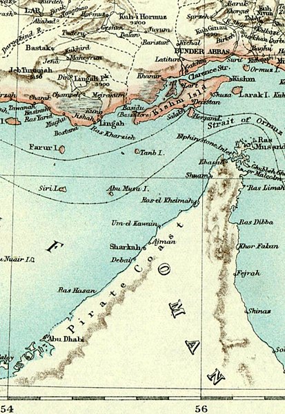
A crop of the Map of Persia (by George Curzon) showing the Strait of Hormuz 1892 - The Royal Geographical Society (with the Institute of British Geographers) Category:Maps of Asia Category:Maps of Iran {{PD-old}}
ไฟล, strait, hormuz, ไฟล, ประว, ไฟล, หน, าท, ภาพน, การใช, ไฟล, ามโครงการ, อม, ลเก, ยวก, บภาพขนาดของต, วอย, างน, กเซล, ความละเอ, ยดอ, กเซล, กเซล, กเซล, ภาพท, ความละเอ, ยดส, งกว, 8206, กเซล, ขนาดไฟล, โลไบต, ชน, ดไมม, image, jpeg, ปภาพหร, อไฟล, เส, ยงน, นฉบ, บอย,. ifl prawtiifl hnathimiphaphni karichiflkhamokhrngkar khxmulekiywkbphaphkhnadkhxngtwxyangni 413 599 phikesl khwamlaexiydxun 165 240 phikesl 331 480 phikesl 938 1 360 phikesl duphaphthimikhwamlaexiydsungkwa 8206 938 1 360 phikesl khnadifl 215 kiolibt chnidimm image jpeg rupphaphhruxiflesiyngni tnchbbxyuthi khxmmxns raylaexiyddanlang epnkhxkhwamthiaesdngphlcak ifltnchbbinkhxmmxns khxmmxnsepnewbistinokhrngkarsahrbekbrwbrwmsuxesri thi khunsamarthchwyid A crop of the Map of Persia by George Curzon showing the Strait of Hormuz1892 The Royal Geographical Society with the Institute of British Geographers Public domain Public domain false false nganniepnsatharnsmbti inpraethstnkaenidaelapraethsxun thirayaewlakarkhumkhrxnglikhsiththinxykwa 70 pihlngcakphusrangsrrkhnganesiychiwit nxkcaknikhunxactxngephimpaysatharnsmbtiinshrthxemrika ephuxrabuwaehtuidngannicungepnsatharnsmbtiinshrthxemrika nbsp oprdthrabwabangpraethsmikhxkahnderuxngkarkhumkhrxnglikhsiththinankwa 70 pi echn emksiok 100 pi caemka 95 pi okhlxmebiy 80 pi kwetmalaaelasamw 75 pi phaphnixacimepnsatharnsmbtiinpraethsehlanisungnganlikhsiththixackhyayipinphlnganthisrangkhunodychawfrngessthiesiychiwitinpraethsfrngesscakehtukarnsngkhramolkkhrngthisxng khxmulephimetim chawrsesiythithahnathiinaenwrbdantawnxxkinsngkhramolkkhrngthisxng hruxeriykxyanghnungwa sngkhramtxtankhwamrkchatixnyingihykhxngrsesiy aelakarphkfunphuesiyhaycakkarthukcxngcainshphaphosewiyt khxmulephimetim iflniidthukrabuwaimmikhxcakdphayitkdhmaylikhsiththi rwmthungsiththithiekiywkhxngaelathiiklekhiyngknhttps creativecommons org publicdomain mark 1 0 PDM Creative Commons Public Domain Mark 1 0 false falseAnnotationsInfoFieldThis image is annotated View the annotations at Commons123 1346 18 11 938 1360 Eine Karte von Adolf Stieler zeigt Abu Musa und grossere und kleinere Tunben als Teil des Iran khabrryayodyyxithyephimkhabrryaythrrthdediywephuxkhyaykhwamwaiflnimixairxngkvs1892 map by UK Royal Geographical Society and Institute of British Geographers No modern data ixethmthiaesdngxyuiniflniprakxbdwymedia type nbsp xngkvsimage jpeg prawtiifl khlikwnthi ewlaephuxduiflthipraktinkhnann wnthi ewlarupyxkhnadphuichkhwamehn pccubn04 14 28 knyayn 2549938 1 360 215 kiolibt KavehA crop of the Map of Persia by George Curzon showing the Strait of Hormuz 1892 The Royal Geographical Society with the Institute of British Geographers Category Maps of Asia Category Maps of Iran PD old hnathimiphaphni hnatxipni oyngmathiphaphni chxngaekhbhxrmus karichiflkhamokhrngkar wikixuntxipniichiflni karichbn ar wikipedia org مضيق هرمز karichbn be tarask wikipedia org Armuskaya pratoka karichbn ca wikipedia org Illa d Ormuz karichbn ckb wikipedia org تەنگاوی ھورمز karichbn de wikipedia org Hormus Insel Gebietsanspruche im Persischen Golf karichbn el wikipedia org Ampoy Moysa karichbn en wikipedia org Strait of Hormuz Abu Musa Hormuz Island Portal Maps Maps Nautical Territorial disputes in the Persian Gulf Portal Maps Maps Nautical 8 Piracy in the Persian Gulf Portal Maps karichbn fa wikipedia org تنب بزرگ مناقشه های سرزمینی در خلیج فارس دزدی دریایی در خلیج فارس karichbn fa wikivoyage org تنب بزرگ karichbn he wikipedia org אבו מוסא אי karichbn hyw wikipedia org Հորմուզի Նեղուց karichbn id wikipedia org Selat Hormuz karichbn it wikipedia org Utente Mario1952 Sandbox8 Campagna britannica nel Golfo Persico del 1819 karichbn ku wikipedia org Tengava Hurmiz karichbn la wikipedia org Fretum Ormusense karichbn ml wikipedia org ഹ ർമ സ കടല ട ക ക karichbn nn wikipedia org Hormuzsundet karichbn pnb wikipedia org خلیج فارس وچ قزاقی خلیج فارس وچ علاقائی تنازعات karichbn pt wikipedia org Abu Musa karichbn sah wikipedia org Һormuz silbeһiite karichbn simple wikipedia org Strait of Hormuz karichbn su wikipedia org Selat Hormuz karichbn ta wikipedia org ஓர ம ச ந ர ண ஹ ர ம ஸ த வ karichbn ur wikipedia org خلیج فارس میں قزاقی خلیج فارس میں علاقائی تنازعات karichbn vi wikipedia org Cac Tiểu vương quốc Ả Rập Thống nhất Eo biển Hormuz karichbn zh wikipedia org 阿布穆萨岛 錫里島khxmulekiywkbphaph phaphnimikhxmulephimetim sungswnihymacakklxngdicitxlhruxsaeknenxrthisamarthekbkhxmuldngklawiwrwmkbphaphid thaphaphnithukprbprungaekikhhruxepliynaeplngcakedim khxmulbangxyangcayngkhngimepliynaeplngehmuxnphaphthithukprbprungaekikhnn 95 error0 ekhathungcak https th wikipedia org wiki ifl Strait of hormuz jpg, wikipedia, วิกิ หนังสือ, หนังสือ, ห้องสมุด,