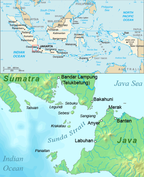
ไฟล, sunda, strait, ไฟล, ประว, ไฟล, หน, าท, ภาพน, การใช, ไฟล, วนกลางไม, ภาพท, รายละเอ, ยดส, งกว, าน, sunda, strait, 8206, กเซล, ขนาดไฟล, โลไบต, ชน, ดไมม, image, ปภาพหร, อไฟล, เส, ยงน, นฉบ, บอย, คอมมอนส, รายละเอ, ยดด, านล, าง, เป, นข, อความท, แสดงผลจาก, ไฟล, นฉ. ifl prawtiifl hnathimiphaphni karichiflswnklangimmiphaphthimiraylaexiydsungkwani Sunda strait map v3 png 8206 489 600 phikesl khnadifl 310 kiolibt chnidimm image png rupphaphhruxiflesiyngni tnchbbxyuthi khxmmxns raylaexiyddanlang epnkhxkhwamthiaesdngphlcak ifltnchbbinkhxmmxns khxmmxnsepnewbistinokhrngkarsahrbekbrwbrwmsuxesri thi khunsamarthchwyid khwamyx khaxthibaySunda strait map v3 png English Map of the Sunda Strait Indonesia wnthi 26 singhakhm ph s 2549aehlngthima Combination of CIA World Factbook map and Demis Map Server http www2 demis nl mapserver mapper asp data with additional annotations and modifications by self phusrangsrrkh ChrisOkarxnuyat karichiflniihm Public domain Public domain false falseThis image is in the public domain because it contains materials that originally came from the United States Central Intelligence Agency s World Factbook Bahasa Indonesia cestina Deutsch eesti English espanol Esperanto francais galego hrvatski italiano Nederlands norsk nynorsk polski portugues sicilianu slovenscina suomi Turkce Zazaki belaruskaya tarashkevica makedonski russkij srpski srpski ukrayinska ქართული ব ল தம ழ മലയ ള 한국어 日本語 中文 中文 简体 中文 繁體 العربية Public domain Public domain false falseThis image is in the public domain because it came from the site https www demis nl products web map server examples and was released by the copyright holder Permission is granted to copy distribute and or modify this map since it is based on free of copyright images from www demis nl See also approval email on de wp and its clarification Deutsch English makedonski മലയ ള Nederlands slovenscina Public domain Public domain false falseThis work has been released into the public domain by its copyright holder www demis nl This applies worldwide inbangpraeths karkrathadngklawxacimsamarththaidtamkdhmaywww demis nl xnuyatihthukkhnmisiththiinkarichiflniinthukehtuphlkarich odyimmimienguxnikh ewnaetkdhmayimxnuyatihthaechnnn Public domain Public domain false falseewxrchnxun lower part demis map only File Sunda strait map v4 pngkhabrryayodyyxithyephimkhabrryaythrrthdediywephuxkhyaykhwamwaiflnimixairixethmthiaesdngxyuiniflniprakxbdwyphusrangbangkhathiimmiixethmwikisnethsyuxaraexl https commons wikimedia org wiki user ChrisOchuxphuichwikimiediy ChrisOchuxphusrangsrrkh ChrisOsthanalikhsiththicopyrighted dedicated to the public domain by copyright holder xngkvssyyaxnuyatreleased into the public domain by the copyright holder xngkvswnthisrang wnkxtng26 singhakhm 2006 prawtiifl khlikwnthi ewlaephuxduiflthipraktinkhnann wnthi ewlarupyxkhnadphuichkhwamehn pccubn17 39 2 thnwakhm 2549489 600 310 kiolibt BurgundoCaricato da en wiki hnathimiphaphni hnatxipni oyngmathiphaphni chxngaekhbsunda karichiflswnklang wikixuntxipniichiflni karichbn ar wikipedia org سانغيانغ بانايتان مضيق سوندا تسونامي مضيق سوندا 2018 karichbn ast wikipedia org Krakatoa karichbn ban wikipedia org Krakatau karichbn ba wikipedia org Zond bogaҙy karichbn bg wikipedia org Krakatau Zondski proliv Most nad Zondskiya proliv karichbn br wikipedia org Krakatau Strizh mor Sunda karichbn ca wikipedia org Estret de la Sonda karichbn cs wikipedia org Tsunami v Sundskem prulivu 2018 karichbn da wikipedia org Krakatau karichbn en wikipedia org Krakatoa Sunda Strait Bridge Sangiang Panaitan Legundi Island Tabuan Island Krakatoa archipelago karichbn en wikinews org 6 4 magnitude earthquake hits Indonesia karichbn es wikipedia org Krakatoa Parque nacional de Ujung Kulon karichbn fa wikipedia org کراکاتوآ تنگه سوندا سونامی ۲۰۱۸ تنگه سوندا karichbn fr wikipedia org Tsunami de 2018 dans le detroit de la Sonde karichbn fy wikipedia org Sundastrjitte karichbn gl wikipedia org Krakatoa karichbn hak wikipedia org Panaitan Sangiang karichbn hi wikipedia org स न द जलसन ध २०१८ स न द जलसन ध स न म karichbn hu wikipedia org Krakatau Szunda szoros karichbn hy wikipedia org Զոնդյան նեղուց karichbn id wikipedia org Krakatau Pulau Tabuan Lampung karichbn it wikipedia org Stretto della Sonda Ponte sullo stretto della Sonda Eruzione del Krakatoa del 1883 Legundi karichbn ja wikipedia org クラカタウ ペナンの歴史 karichbn kk wikipedia org Zond bugazy karichbn ko wikipedia org 순다 해협 karichbn ku wikipedia org Tengava Sunda karichbn lt wikipedia org Sundos sasiauris dukarichthwolkephimetimkhxngiflni ekhathungcak https th wikipedia org wiki ifl Sunda strait map v3 png, wikipedia, วิกิ หนังสือ, หนังสือ, ห้องสมุด,