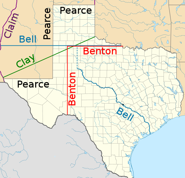
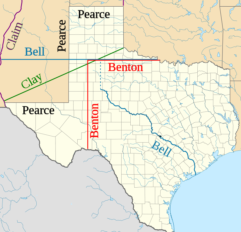
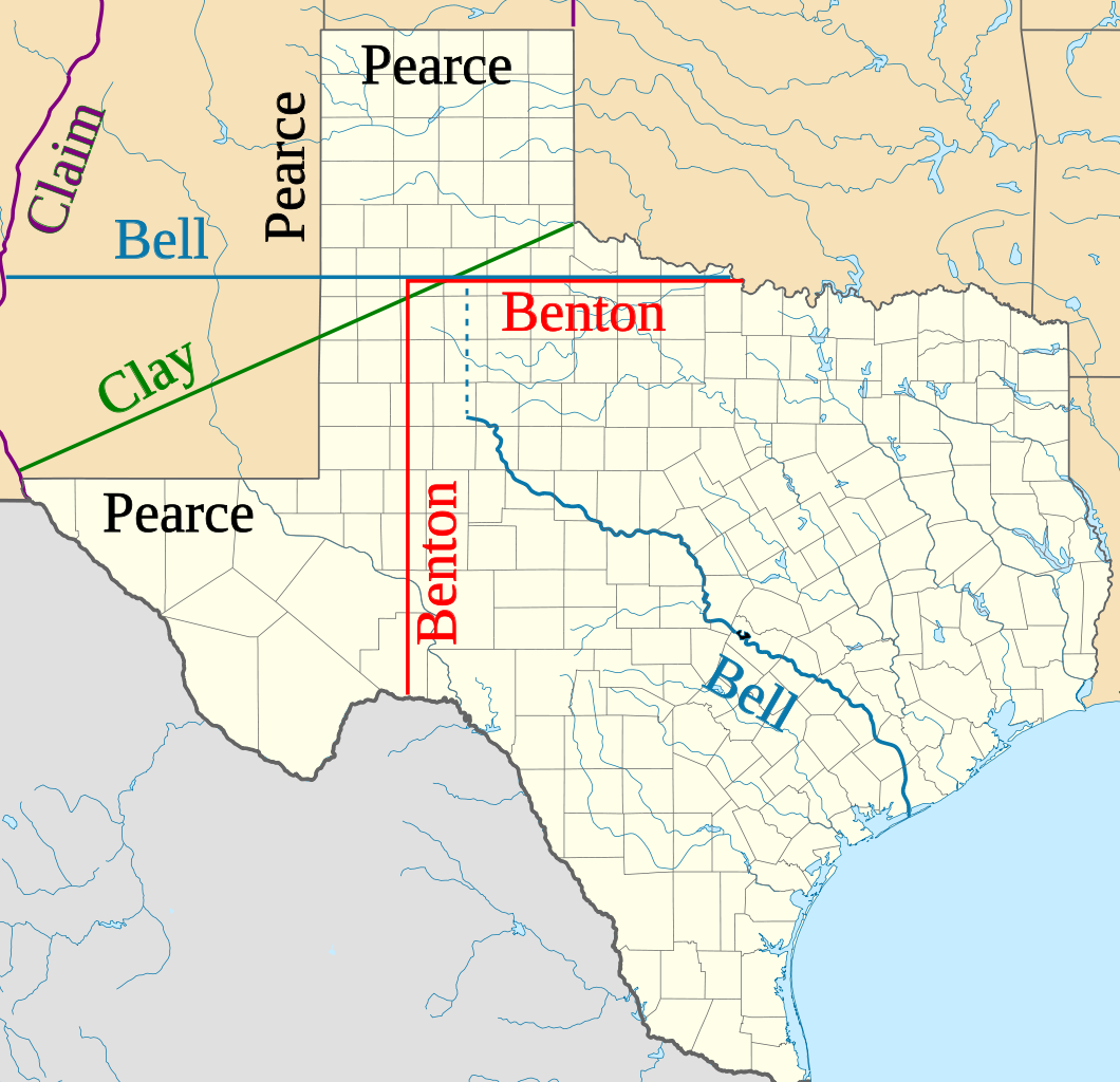
ไฟล, texas, proposed, boundaries, ไฟล, ประว, ไฟล, หน, าท, ภาพน, การใช, ไฟล, ามโครงการขนาดของต, วอย, าง, ของไฟล, กเซล, ความละเอ, ยดอ, กเซล, กเซล, กเซล, กเซล, กเซล, กเซล, ภาพท, ความละเอ, ยดส, งกว, 8206, ไฟล, กเซล, ขนาดไฟล, โลไบต, ปภาพหร, อไฟล, เส, ยงน, นฉบ, บอย,. ifl prawtiifl hnathimiphaphni karichiflkhamokhrngkarkhnadkhxngtwxyang PNG nikhxngifl SVG ni 621 600 phikesl khwamlaexiydxun 248 240 phikesl 497 480 phikesl 795 768 phikesl 1 060 1 024 phikesl 2 120 2 048 phikesl 1 475 1 425 phikesl duphaphthimikhwamlaexiydsungkwa 8206 ifl SVG 1 475 1 425 phikesl khnadifl 697 kiolibt rupphaphhruxiflesiyngni tnchbbxyuthi khxmmxns raylaexiyddanlang epnkhxkhwamthiaesdngphlcak ifltnchbbinkhxmmxns khxmmxnsepnewbistinokhrngkarsahrbekbrwbrwmsuxesri thi khunsamarthchwyid khaxthibayTexas proposed boundaries svg Northern and western boundaries of Texas proposed by various Senators in the Compromise of 1850 debate wnthi 28 mkrakhm ph s 2553 23 47 UTC aehlngthima USA Texas location map svg phusrangsrrkh USA Texas location map svg Alexrk derivative work JWB talk phaphni idrbkarprbaetngphaph sunghmaykhwamwacaidrbkarepliynaeplngphaphtangcaktnchbb karprbprung Proposed boundaries for Compromise of 1850 tnchbbsamarthduidthini USA Texas location map svg prbaetngphaphody JWB nbsp khapheca inthanaphuthuxlikhsiththikhxngphaphhruxsuxni xnuyatihichphaphhruxsuxniphayitenguxnikhtxipni iflnixyuphayitsyyaxnuyatkhriexthifkhxmmxns run aesdngthima 3 0 tnchbbkhunsamarth thicaaebngpn thicathasaena aeckcay aelasngngandngklawtxip thicaeriyberiyngihm thicaddaeplngngandngklaw phayitenguxnikhtxipni aesdngthima khuntxngihekiyrtiecakhxngnganxyangehmaasm odyephimlingkipyngsyyaxnuyat aelarabuhakmikarepliynaeplng khunxacthaechnniidinrupaebbidkidtamkhwr aettxngimichinlksnathiaenawaphuihxnuyatsnbsnunkhunhruxkarichngankhxngkhunhttps creativecommons org licenses by 3 0 CC BY 3 0 Creative Commons Attribution 3 0 true true xnuyatihkhdlxk aeckcayaela hruxddaeprexksarniphayitenguxnikhkhxngsyyaxnuyatexksaresrikhxngknu run 1 2 hruxrunid nbcaknithixxkodymulnithisxftaewresri odyimmiswnidhamaekikh immikhxkhwampkhnaaelapkhlng saenakhxngsyyaxnuyatrwmxyuinswnchux syyaxnuyatexksaresrikhxngknuhttp www gnu org copyleft fdl html GFDL GNU Free Documentation License true true khunsamartheluxksyyaxnuyatdngklawtamtxngkar bnthukkarxphohld This image is a derivative work of the following images File USA Texas location map svg licensed with Cc by 3 0 GFDL 2009 06 17T20 30 36Z Alexrk2 1500x1484 711918 Bytes enh 2009 06 07T13 05 09Z Alexrk 1500x1484 571429 Bytes water bodies 1 10mio 2009 06 06T21 43 21Z Alexrk 1500x1484 870861 Bytes GeneralizationDistance 2px 2009 06 06T17 41 11Z Alexrk 1500x1485 1550930 Bytes Beschreibung Information Description de Positionskarte von de Texas Texas de USA USA Quadratische Plattkarte N S Streckung 120 nbsp Geographische Begrenzung der Karte N 36 8 N S 25 5 N W Uploaded with derivativeFXkhabrryayodyyxithyephimkhabrryaythrrthdediywephuxkhyaykhwamwaiflnimixairixethmthiaesdngxyuiniflniprakxbdwysthanalikhsiththimilikhsiththisyyaxnuyatGNU Free Documentation License version 1 2 or later nbsp xngkvsCreative Commons Attribution 3 0 Unported nbsp xngkvswnthisrang wnkxtng28 mkrakhm 2010 prawtiifl khlikwnthi ewlaephuxduiflthipraktinkhnann wnthi ewlarupyxkhnadphuichkhwamehn pccubn07 11 29 mkrakhm 25531 475 1 425 697 kiolibt JWBIdentify more of Pearce and Benton lines 07 03 29 mkrakhm 25531 475 1 425 696 kiolibt JWBIdentify final proposal as Pearce 039 s 06 52 29 mkrakhm 25531 475 1 425 696 kiolibt JWBTweaks 06 50 29 mkrakhm 25531 475 1 400 696 kiolibt JWB Information Description Northern and western boundaries of Texas proposed by various Senators in the Compromise of 1850 debate Source File USA Texas location map svg Date 2010 01 28 23 47 UTC Author File USA Texas location map svg hnathimiphaphni hnatxipni oyngmathiphaphni satharnrthethkss karichiflkhamokhrngkar wikixuntxipniichiflni karichbn af wikipedia org Republiek van Texas karichbn azb wikipedia org تکزاس جومهوریتی karichbn cy wikipedia org Worth County Texas karichbn en wikipedia org Republic of Texas Compromise of 1850 History of New Mexico Texas divisionism User JWB Worth County Texas User talk Tuckerresearch Talk Archive 2018 User Falcaorib Portal New Mexico karichbn fy wikipedia org Teksas karichbn id wikipedia org Republik Texas karichbn it wikipedia org Origini della guerra di secessione americana karichbn ja wikipedia org 9月9日 karichbn kk wikipedia org Tehas karichbn mk wikipedia org Teksas Republika Teksas karichbn ms wikipedia org Republik Texas karichbn pt wikipedia org Republica do Texas karichbn ro wikipedia org Republica Texas karichbn ru wikipedia org Razdel Tehasa karichbn uz wikipedia org Texas karichbn vi wikipedia org Texas karichbn www wikidata org Q17044295 ekhathungcak https th wikipedia org wiki ifl Texas proposed boundaries svg, wikipedia, วิกิ หนังสือ, หนังสือ, ห้องสมุด,