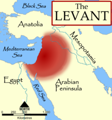
The Levant, based on a NormanEinstein's Image:Fertile Crescent blank base map.png.
วันที่
3 ตุลาคม พ.ศ. 2549 (original upload date)
แหล่งที่มา
No machine-readable source provided. Own work assumed (based on copyright claims).
ผู้สร้างสรรค์
No machine-readable author provided. MapMaster assumed (based on copyright claims).
เวอร์ชันอื่น
[แก้ไข]
1
English (original)
Nederlands
العربية
2
српски / srpski
íslenska
қазақша (PNG)
3
русский
მარგალური
References
The American Heritage Dictionary of the English Language, Fourth Edition, Houghton Mifflin Company. "The countries bordering on the eastern Mediterranean Sea from Turkey to Egypt."
Random House Dictionary, Random House, Inc. 2009. "The lands bordering the E shores of the Mediterranean Sea."
Harris, William W. (2005) The Levant: a fractured mosaic, Markus Wiener, Second Edition, map p. 4, quote p. 1. "The Mediterranean littoral between the mountains of Cilicia and the Sinai peninsula."
Oriental Institute, "Levant Site Map", University of Chicago, accessed 15 Dec 2009.
Council for British Research in the Levant, "The CBRL is the British Academy sponsored society that supports research in the humanities and social sciences in the countries of the Levant: Cyprus, Israel, Jordan, Lebanon, Palestine and Syria, . . .", accessed 15 Dec 2009.
Biblical and Levantine studies at UCLA, "The ancient cultures of the Levant are defined to include those of western Syria, Lebanon, Israel, Jordan, the Palestinian territories, the Egyptian Sinai, and Cyprus."
ไฟล, levant, ไฟล, ประว, ไฟล, หน, าท, ภาพน, การใช, ไฟล, วนกลาง, อม, ลเก, ยวก, บภาพขนาดของต, วอย, างน, กเซล, ความละเอ, ยดอ, กเซล, กเซล, กเซล, ภาพท, ความละเอ, ยดส, งกว, 8206, กเซล, ขนาดไฟล, โลไบต, ชน, ดไมม, image, ปภาพหร, อไฟล, เส, ยงน, นฉบ, บอย, คอมมอนส, รายละเอ. ifl prawtiifl hnathimiphaphni karichiflswnklang khxmulekiywkbphaphkhnadkhxngtwxyangni 558 600 phikesl khwamlaexiydxun 223 240 phikesl 447 480 phikesl 922 991 phikesl duphaphthimikhwamlaexiydsungkwa 8206 922 991 phikesl khnadifl 290 kiolibt chnidimm image png rupphaphhruxiflesiyngni tnchbbxyuthi khxmmxns raylaexiyddanlang epnkhxkhwamthiaesdngphlcak ifltnchbbinkhxmmxns khxmmxnsepnewbistinokhrngkarsahrbekbrwbrwmsuxesri thi khunsamarthchwyid enuxha 1 khwamyx 2 References 3 karxnuyatichsiththi 4 derivative works khwamyx khaxthibayThe Levant 3 png The Levant based on a NormanEinstein s Image Fertile Crescent blank base map png wnthi 3 tulakhm ph s 2549 original upload date aehlngthima No machine readable source provided Own work assumed based on copyright claims phusrangsrrkh No machine readable author provided MapMaster assumed based on copyright claims ewxrchnxun aekikh 1 English original Nederlands العربية 2 srpski srpski islenska kazaksha PNG 3 russkij მარგალური References The American Heritage Dictionary of the English Language Fourth Edition Houghton Mifflin Company The countries bordering on the eastern Mediterranean Sea from Turkey to Egypt Random House Dictionary Random House Inc 2009 The lands bordering the E shores of the Mediterranean Sea Harris William W 2005 The Levant a fractured mosaic Markus Wiener Second Edition map p 4 quote p 1 The Mediterranean littoral between the mountains of Cilicia and the Sinai peninsula Oriental Institute Levant Site Map University of Chicago accessed 15 Dec 2009 Council for British Research in the Levant The CBRL is the British Academy sponsored society that supports research in the humanities and social sciences in the countries of the Levant Cyprus Israel Jordan Lebanon Palestine and Syria accessed 15 Dec 2009 Biblical and Levantine studies at UCLA The ancient cultures of the Levant are defined to include those of western Syria Lebanon Israel Jordan the Palestinian territories the Egyptian Sinai and Cyprus karxnuyatichsiththi khapheca inthanaphuthuxlikhsiththikhxngphaphhruxsuxni xnuyatihichphaphhruxsuxniphayitenguxnikhtxipni xnuyatihkhdlxk aeckcayaela hruxddaeprexksarniphayitenguxnikhkhxngsyyaxnuyatexksaresrikhxngknu run 1 2 hruxrunid nbcaknithixxkodymulnithisxftaewresri odyimmiswnidhamaekikh immikhxkhwampkhnaaelapkhlng saenakhxngsyyaxnuyatrwmxyuinswnchux syyaxnuyatexksaresrikhxngknuhttp www gnu org copyleft fdl html GFDL GNU Free Documentation License true true iflnixyuphayitsyyaxnuyat khriexthifkhxmmxns aebbaesdngthima xnuyataebbediywkn 3 0 tnchbb khunsamarth thicaaebngpn thicathasaena aeckcay aelasngngandngklawtxip thicaeriyberiyngihm thicaddaeplngngandngklaw phayitenguxnikhtxipni aesdngthima khuntxngihekiyrtiecakhxngnganxyangehmaasm odyephimlingkipyngsyyaxnuyat aelarabuhakmikarepliynaeplng khunxacthaechnniidinrupaebbidkidtamkhwr aettxngimichinlksnathiaenawaphuihxnuyatsnbsnunkhunhruxkarichngankhxngkhun xnuyataebbediywkn hakkhunddaeplng epliynrup hruxtxetimnganni khuntxngichsyyaxnuyataebbediywknhruxaebbthiehmuxnkbsyyaxnuyatthiichkbnganniethann payaesdngsthanalikhsiththinithukephimephuxihepniptamkarepliynaeplngsyyaxnuyatkhxngmulnithiwikimiediy cak GFDL ipyng GFDL khwbkhukb CC BY SA 3 0 http creativecommons org licenses by sa 3 0 CC BY SA 3 0 Creative Commons Attribution Share Alike 3 0 true truekhunsamartheluxksyyaxnuyatdngklawtamtxngkar derivative works iflxunthiichiflni nbsp The Levant ar png phaphaephnthirabutaaehnngni khwrcathuksrangihmepnkrafiksewketxr sungmikhxdixikhlayprakar duephimetimthikhxmmxns suxtxngkarekbkwadsahrbsarsnethsephimetim hakphaphnimiinrupaebbkrafiksewketxrxyuaelw krunaxpohldaelaaethnthiaemaebbnidwy vector version available i chuxphaphihm i aenanaepnxyangyingihtngchuxiflewketxrihmnninrupaebb The Levant 3 svg aelwisaemaebb Vector version available hrux Vva sungimtxngichpharamietxr chuxphaphihmkhabrryayodyyxithyephimkhabrryaythrrthdediywephuxkhyaykhwamwaiflnimixairixethmthiaesdngxyuiniflniprakxbdwysthanalikhsiththimilikhsiththisyyaxnuyatGNU Free Documentation License version 1 2 or later nbsp xngkvsCreative Commons Attribution ShareAlike 3 0 Unported nbsp xngkvswnthisrang wnkxtng3 tulakhm 2006 prawtiifl khlikwnthi ewlaephuxduiflthipraktinkhnann wnthi ewlarupyxkhnadphuichkhwamehn pccubn01 57 12 tulakhm 2557922 991 290 kiolibt Spiridon Ion CepleanuMinor change diffuse limits 08 32 4 tulakhm 2549922 991 237 kiolibt MapMasterFixed some problems 10 54 3 tulakhm 2549922 991 215 kiolibt MapMasterThe Levant based on a NormanEinstein 039 s Image Fertile Crescent blank base map png hnathimiphaphni hnatxipni oyngmathiphaphni liaewnt karichiflswnklang wikixuntxipniichiflni karichbn ast wikipedia org Llevante mediterraneu karichbn az wikipedia org Levant karichbn ba wikipedia org Levant karichbn be wikipedia org Levant karichbn bg wikipedia org Levant karichbn ca wikipedia org Edat del bronze Llevant Orient Proxim Historia del Liban Noms del Llevant karichbn ckb wikipedia org شام karichbn cs wikipedia org Levanta karichbn cv wikipedia org Avalhi Rim Visanti Parhi ĕmpylĕhĕ Hettsem Akkad Assiri Shablon Levantri tahcanhi patshalăhsem tata oblacsem Levant Selevkidsen patshalăhĕ Aramejsem Katna Ugarit Ninevi Ahemenidsen patshalӑhӗ karichbn de wikipedia org Benutzer KaterBegemot Kartografen Benutzer Deutschhilde Geschichte der sudlichen Levante karichbn diq wikipedia org Levant karichbn el wiktionary org lebantes lebante karichbn en wikipedia org User Dimadick Coele Syria Talk Pre Islamic Arabia User Zdunne User Antoine75 User Teemu08 User MapMaster User Gwilym84 User Zozoulia User Motacilla User James H Jenkins User Kleopatraisyra User Aus Chia User Imeriki al Shimoni User L smithfield User WisamFarouk Template User Levantine History User Jonathan48 User Hiram111 User Thaum1el About me dukarichthwolkephimetimkhxngiflnikhxmulekiywkbphaph phaphnimikhxmulephimetim sungswnihymacakklxngdicitxlhruxsaeknenxrthisamarthekbkhxmuldngklawiwrwmkbphaphid thaphaphnithukprbprungaekikhhruxepliynaeplngcakedim khxmulbangxyangcayngkhngimepliynaeplngehmuxnphaphthithukprbprungaekikhnnkhwamlaexiydaenwnxn28 35 dpckhwamlaexiydaenwtng28 35 dpc ekhathungcak https th wikipedia org wiki ifl The Levant 3 png, wikipedia, วิกิ หนังสือ, หนังสือ, ห้องสมุด,