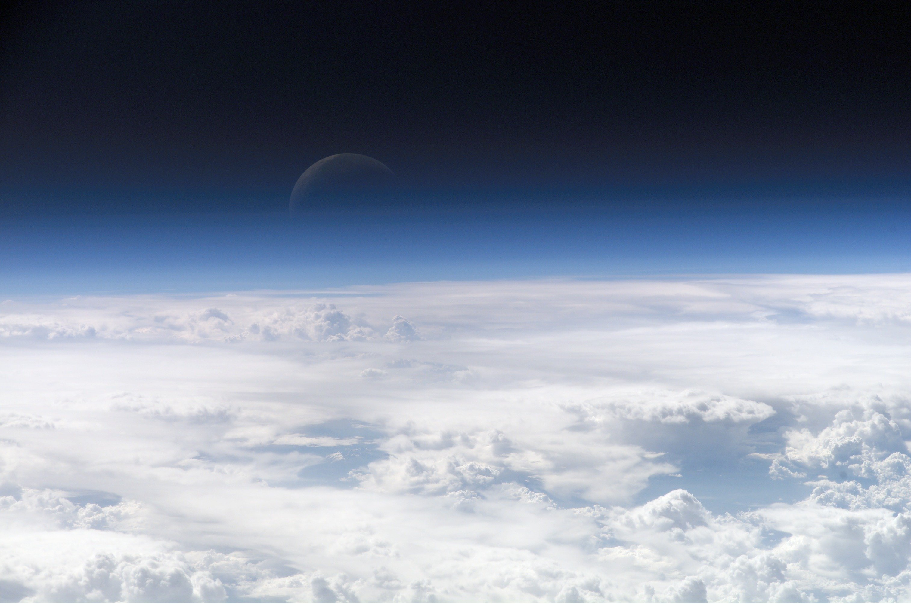
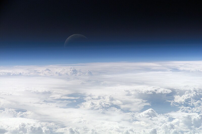
English: View of the crescent moon through the top of the earth's atmosphere. Photographed from International Space Station by Expedition 13 crew over the South China Sea, just south of Macau.
ภาษาอื่น ๆ:
Čeština: Pohled na srpek Měsíce skrz vršek zemské atmosféry. Vyfoceno posádkou Mezinárodní vesmírné stanice v rámci Expedice 13 nad Jihočínským mořem jižně od Macaa, 21,5° S, 113,3° V
Deutsch: Die oberen Schichten der Erdatmosphäre, gesehen von der Internationalen Raumstation (ISS) während der ISS-Expedition 13
English: View of the crescent moon through the top of the earth's atmosphere. Photographed from International Space Station by Expedition 13 crew over the South China Sea, just south of Macau.
Italiano: Vista della luna crescente dalla sommità dell'atmosfera terrestre. Foto scattata alle coordinate 21.5°N, 113.3°E dall'equipaggio della Stazione Spaziale Orbitante Internazionale Expedition 13 sopra il Mar Cinese Orientale, appena a sud di Macau (NASA image ID: ISS013-E-54329).
Magyar: Félholdra táruló kilátás a Föld légkörén keresztül. A fénykép a Nemzetközi Űrállomás 13-dik expedícióján, a Dél-kínai-tenger fölött, Makaótól délre készült.
Nederlands: Zicht op de maansikkel door de bovenkant van de atmosfeer van de aarde. Gefotografeerd boven 21,5° N, 113,3° E door de bemanning van het internationaal ruimtestation ISS tijdens expeditie 13 boven de Zuid-Chinese Zee, net ten zuiden van Macau.
Polski: Widok Księżyca z górnych warstw amosfery ziemskiej. Fotografia wykonana przez załogę Ekspedycji 13 Międzynarodowej Stacji Kosmicznej nad Morzem Południowochińskim, na południe od Makau
Svenska: En månskära sedd genom atmosfärens övre lager, fotograferad från Internationella rymdstationen ovanför Sydkinesiska sjön söder om Macau.
ქართული: სამხრეთი ჩინეთის ზღვის თავზე, მაკაოს სამხრეთით, მე-13 ექსპედიციის მონაწილის მიერ გადაღებული ნახევარმთვარის ფოტო დედამიწის ატმოსფეროს ზედა ფენებიდან.
한국어: 지구의 대기 상공에서 바라본 초승달. 국제 우주 정거장에서 남중국해를 지날 때 촬영되었다.
Čeština: Pohled na srpek Měsíce skrz vršek zemské atmosféry. Vyfoceno posádkou Mezinárodní vesmírné stanice v rámci Expedice 13 nad Jihočínským mořem jižně od Macaa, 21,5° S, 113,3° V
English: View of the crescent moon through the top of the Earth's atmosphere. Photographed above 21.5°N, 113.3°E by International Space Station crew Expedition 13 over the South China Sea, just south of Macau (NASA image ID: ISS013-E-54329).
Français : Photo des couches hautes de l'atmosphère terrestre, prise par 21.5°N, 113.3°E par la Station spatiale internationale au cours de l'Expédition 13 au-dessus de la Mer de Chine méridionale, juste au sud de Macao. Numéro d'identification d'image de la NASA : ISS013-E-54329.
Italiano: Vista della luna crescente dalla sommità dell'atmosfera terrestre. Foto scattata alle coordinate 21.5°N, 113.3°E dall'equipaggio della Stazione Spaziale Internazionale Expedition 13 sopra il Mar Cinese Orientale, appena a sud di Macau (NASA image ID: ISS013-E-54329).
ქართული: სამხრეთი ჩინეთის ზღვის თავზე, მაკაოს სამხრეთით, მე-13 ექსპედიციის მონაწილის მიერ გადაღებული ნახევარმთვარის ფოტო დედამიწის ატმოსფეროს ზედა ფენებიდან.
Polski: Zdjęcie górnych warstw atmosfery ziemskiej z widocznym przejściem w przestrzeń kosmiczną.
Ελληνικά: Η Γήινη ατμόσφαιρα, η φωτογραφία ελήφθη από το διάστημα κι ύψος 335 χιλιόμετρα
This image or video was catalogued by one of the centers of the United States National Aeronautics and Space Administration (NASA) under Photo ID: ISS013-E-54329.
This tag does not indicate the copyright status of the attached work. A normal copyright tag is still required.See Commons:Licensing.
Other languages:
العربية ∙ беларуская (тарашкевіца) ∙ български ∙ català ∙ čeština ∙ dansk ∙ Deutsch ∙ English ∙ español ∙ فارسی ∙ français ∙ galego ∙ magyar ∙ հայերեն ∙ Bahasa Indonesia ∙ italiano ∙ 日本語 ∙ македонски ∙ മലയാളം ∙ Nederlands ∙ polski ∙ português ∙ русский ∙ sicilianu ∙ slovenščina ∙ Türkçe ∙ українська ∙ 简体中文 ∙ 繁體中文 ∙ +/−
การอนุญาตใช้สิทธิ
Public domainPublic domainfalsefalse
Image information
Identification
Top Of The Atmosphere
Mission: ISS013 Roll: E Frame: 54329 Mission ID on the Film or image: ISS013
Country or Geographic Name:
Features: EARTH LIMB, MOON, CLOUD TOPS
Center Point Latitude: Center Point Longitude: (Negative numbers indicate south for latitude and west for longitude)
Stereo: (Yes indicates there is an adjacent picture of the same area)
{{Information |Description= Image of the top layers of the earth's atmosphere leading to space |Source= [http://eobadmin.gsfc.nasa.gov/Newsroom/NewImages/images.php3?img_id=17542] direct link:[http://eobadmin.gsfc.nasa.gov/Newsroom/NewImages/Images/ISS01
ไฟล, atmosphere, ไฟล, ประว, ไฟล, หน, าท, ภาพน, การใช, ไฟล, วนกลางขนาดของต, วอย, างน, กเซล, ความละเอ, ยดอ, กเซล, กเซล, กเซล, กเซล, กเซล, ภาพท, ความละเอ, ยดส, งกว, 8206, กเซล, ขนาดไฟล, โลไบต, ชน, ดไมม, image, jpeg, ปภาพหร, อไฟล, เส, ยงน, นฉบ, บอย, คอมมอนส, รายละ. ifl prawtiifl hnathimiphaphni karichiflswnklangkhnadkhxngtwxyangni 800 531 phikesl khwamlaexiydxun 320 212 phikesl 640 425 phikesl 1 024 680 phikesl 1 280 850 phikesl 3 027 2 010 phikesl duphaphthimikhwamlaexiydsungkwa 8206 3 027 2 010 phikesl khnadifl 543 kiolibt chnidimm image jpeg rupphaphhruxiflesiyngni tnchbbxyuthi khxmmxns raylaexiyddanlang epnkhxkhwamthiaesdngphlcak ifltnchbbinkhxmmxns khxmmxnsepnewbistinokhrngkarsahrbekbrwbrwmsuxesri thi khunsamarthchwyid POTD phaphniepn phaphpracawn emuxwnthi imthrabwn 2013 nikhuxphaphkhdsrrinwikimiediykhxmmxns Featured pictures aela khux thuxwaepn phaphxyangidxyanghnungthidithisud nbsp dwy xtraswn 8 5 16 10 hrux 16 9 phaphnicungehmaasmthicaichin phaphphunhlngkhxngkhxmphiwetxraebbiwdskrin du phaphthnghmd wikiphiediy nbsp nikhuxphaphkhdsrrinwikiphiediyphasaxaesxribcan Secilmis sekiller aela khux thuxwaepn phaphxyangidxyanghnungthidithisud nbsp nikhuxphaphkhdsrrinwikiphiediyphasaxngkvs Featured pictures aela khux thuxwaepn phaphxyangidxyanghnungthidithisud nbsp nikhuxphaphkhdsrrinwikiphiediyphasaepxresiy نگاره های برگزیده aela khux thuxwaepn phaphxyangidxyanghnungthidithisud nbsp nikhuxphaphkhdsrrinwikiphiediyphasaturki Seckin resimler aela khux thuxwaepn phaphxyangidxyanghnungthidithisud hakkhunmiphaphthimikhunphaph khlaykhlungkn thicasamarthephyaephridtam syyaxnuyatthiehmaasm ihaenicwa khunid xpohld kahndsyyaxnuyat aelaid esnxchuxaelw phaphniidrbkarkhdsrrihepn phaphpracawn sahrbwnthi 22 kumphaphnth ph s 2556 phaphdngklawmikhaxthibaydngtxipni English View of the crescent moon through the top of the earth s atmosphere Photographed from International Space Station by Expedition 13 crew over the South China Sea just south of Macau phasaxun Cestina Pohled na srpek Mesice skrz vrsek zemske atmosfery Vyfoceno posadkou Mezinarodni vesmirne stanice v ramci Expedice 13 nad Jihocinskym morem jizne od Macaa 21 5 S 113 3 VDeutsch Die oberen Schichten der Erdatmosphare gesehen von der Internationalen Raumstation ISS wahrend der ISS Expedition 13English View of the crescent moon through the top of the earth s atmosphere Photographed from International Space Station by Expedition 13 crew over the South China Sea just south of Macau Italiano Vista della luna crescente dalla sommita dell atmosfera terrestre Foto scattata alle coordinate 21 5 N 113 3 E dall equipaggio della Stazione Spaziale Orbitante Internazionale Expedition 13 sopra il Mar Cinese Orientale appena a sud di Macau NASA image ID ISS013 E 54329 Magyar Felholdra tarulo kilatas a Fold legkoren keresztul A fenykep a Nemzetkozi Urallomas 13 dik expediciojan a Del kinai tenger folott Makaotol delre keszult Nederlands Zicht op de maansikkel door de bovenkant van de atmosfeer van de aarde Gefotografeerd boven 21 5 N 113 3 E door de bemanning van het internationaal ruimtestation ISS tijdens expeditie 13 boven de Zuid Chinese Zee net ten zuiden van Macau Polski Widok Ksiezyca z gornych warstw amosfery ziemskiej Fotografia wykonana przez zaloge Ekspedycji 13 Miedzynarodowej Stacji Kosmicznej nad Morzem Poludniowochinskim na poludnie od MakauSvenska En manskara sedd genom atmosfarens ovre lager fotograferad fran Internationella rymdstationen ovanfor Sydkinesiska sjon soder om Macau ქართული სამხრეთი ჩინეთის ზღვის თავზე მაკაოს სამხრეთით მე 13 ექსპედიციის მონაწილის მიერ გადაღებული ნახევარმთვარის ფოტო დედამიწის ატმოსფეროს ზედა ფენებიდან 한국어 지구의 대기 상공에서 바라본 초승달 국제 우주 정거장에서 남중국해를 지날 때 촬영되었다 中文 地球大气层上的新月 地理位置为中国南海上空 经纬度21 5 N 113 3 E 由国际空间站第13远征组成员拍摄 khwamyx khaxthibayTop of Atmosphere jpg Cestina Pohled na srpek Mesice skrz vrsek zemske atmosfery Vyfoceno posadkou Mezinarodni vesmirne stanice v ramci Expedice 13 nad Jihocinskym morem jizne od Macaa 21 5 S 113 3 V English View of the crescent moon through the top of the Earth s atmosphere Photographed above 21 5 N 113 3 E by International Space Station crew Expedition 13 over the South China Sea just south of Macau NASA image ID ISS013 E 54329 Francais nbsp Photo des couches hautes de l atmosphere terrestre prise par 21 5 N 113 3 E par la Station spatiale internationale au cours de l Expedition 13 au dessus de la Mer de Chine meridionale juste au sud de Macao Numero d identification d image de la NASA nbsp ISS013 E 54329 Italiano Vista della luna crescente dalla sommita dell atmosfera terrestre Foto scattata alle coordinate 21 5 N 113 3 E dall equipaggio della Stazione Spaziale Internazionale Expedition 13 sopra il Mar Cinese Orientale appena a sud di Macau NASA image ID ISS013 E 54329 ქართული სამხრეთი ჩინეთის ზღვის თავზე მაკაოს სამხრეთით მე 13 ექსპედიციის მონაწილის მიერ გადაღებული ნახევარმთვარის ფოტო დედამიწის ატმოსფეროს ზედა ფენებიდან Polski Zdjecie gornych warstw atmosfery ziemskiej z widocznym przejsciem w przestrzen kosmiczna Ellhnika H Ghinh atmosfaira h fwtografia elhf8h apo to diasthma ki ypsos 335 xiliometra wnthi 20 krkdakhm ph s 2549 aehlngthima http eol jsc nasa gov scripts sseop photo pl mission ISS013 amp roll E amp frame 54329 phusrangsrrkh NASA Earth Observatory This image or video was catalogued by one of the centers of the United States National Aeronautics and Space Administration NASA nbsp under Photo nbsp ID ISS013 E 54329 This tag does not indicate the copyright status of the attached work A normal copyright tag is still required See Commons Licensing Other languages العربية nbsp belaruskaya tarashkevica nbsp blgarski nbsp catala nbsp cestina nbsp dansk nbsp Deutsch nbsp English nbsp espanol nbsp فارسی nbsp francais nbsp galego nbsp magyar nbsp հայերեն nbsp Bahasa Indonesia nbsp italiano nbsp 日本語 nbsp makedonski nbsp മലയ ള nbsp Nederlands nbsp polski nbsp portugues nbsp russkij nbsp sicilianu nbsp slovenscina nbsp Turkce nbsp ukrayinska nbsp 简体中文 nbsp 繁體中文 nbsp karxnuyatichsiththi Public domain Public domain false false phaphniepnsatharnsmbti enuxngcakepnphaphthisrangkhunodyxngkhkarbriharkarbinaelaxwkasaehngchati NASA sungtamnoybaydanlikhsiththikhxngnasarabuiwwa phaphaelasuxtang khxngnasaimidrbkarkhumkhrxngodylikhsiththiykewncarabuiwwamilikhsiththi duephimthi hnanoybaydanlikhsiththikhxngnasa hrux noybaykarichphaphkhxng JPL khaetuxn karich olokkhxngnasa ekhruxnghmayaelaekhruxngpradbkhxngnasa thukcakddwykdhmayshrthxemrikainlksna 14 khxngkhxbngkhbthangrachkarshrthxemrika swnthi 1221 ewbistkhxngnasaekbrwbrwmphaphthimacakxngkhkarxwkasosewiyt xngkhkarxwkasaehngchatirsesiy aelaxngkhkarxwkasthimiichxngkhkarxwkaskhxngshrthxemrika epncanwnmak phaphehlaniimcaepntxngepnsatharnsmbtiesmxip phaphhruxsuxthimacak klxngothrthrrsnxwkashbebil xacmilikhsiththi hakphaphhruxsuxnnimidrabuchdecnwamacak sthabnwithyasastrklxngothrthrrsnxwkas 1 phaphhruxsuxthnghmdthimacakekhruxngmuxkhxng okhrngkarsuksadwngxathityaelalmsuriya milikhsiththi karnaphaphhruxsuxcakokhrngkaripichnxkehnuxcakkarichephuxkarkhahruxephuxkarsuksa txngidrbxnuyatkxn 2 phaphthithukkhdeluxkihepn phaphdarasastrpracawn APOD bnewbistkhxng APOD xacmilikhsiththi 3 Image information IdentificationTop Of The AtmosphereMission ISS013 Roll E Frame 54329 Mission ID on the Film or image ISS013Country or Geographic Name Features EARTH LIMB MOON CLOUD TOPSCenter Point Latitude Center Point Longitude Negative numbers indicate south for latitude and west for longitude Stereo Yes indicates there is an adjacent picture of the same area ONC Map ID JNC Map ID MORALES Camera Tilt Low ObliqueCamera Focal Length 400mmCamera E4 Kodak DCS760C Electronic Still CameraFilm 3060E nbsp 3060 x 2036 pixel CCD RGBG array QualityFilm Exposure Percentage of Cloud Cover 100 76 100 NadirDate 20060720 YYYYMMDD GMT Time 082858 HHMMSS Nadir Point Latitude 21 5 Longitude 113 3 Negative numbers indicate south for latitude and west for longitude Nadir to Photo Center Direction Sun Azimuth 281 Clockwise angle in degrees from north to the sun measured at the nadir point Spacecraft Altitude 181 nautical miles 335 km Sun Elevation Angle 35 Angle in degrees between the horizon and the sun measured at the nadir point Orbit Number 3839khabrryayodyyxithyephimkhabrryaythrrthdediywephuxkhyaykhwamwaiflnimixairrsesiyPanoramaixethmthiaesdngxyuiniflniprakxbdwybrryakasCommons quality assessment nbsp xngkvsWikimedia Commons featured picture nbsp xngkvswnthisrang wnkxtng20 krkdakhm 2006 prawtiifl khlikwnthi ewlaephuxduiflthipraktinkhnann wnthi ewlarupyxkhnadphuichkhwamehn pccubn15 09 27 kumphaphnth 25503 027 2 010 543 kiolibt SirGrant Information Description Image of the top layers of the earth 039 s atmosphere leading to space Source http eobadmin gsfc nasa gov Newsroom NewImages images php3 img id 17542 direct link http eobadmin gsfc nasa gov Newsroom NewImages Images ISS01 hnathimiphaphni hnatxipni oyngmathiphaphni thrrmchati brryakaskhxngolk singaewdlxmthangthrrmchati phuich Thitut thdlxngekhiyn esnkharaemn karichiflswnklang wikixuntxipniichiflni karichbn af wikipedia org Lug en ruimtevaart Wikipedia Beeld van die week 2013 Wikipedia Voorbladbeeld week 13 2013 Atmosfeer Karman lyn karichbn ami wikipedia org Kasata edi edip no lahod karichbn am wikipedia org ከባቢ አየር karichbn anp wikipedia org व य म डल karichbn an wikipedia org Atmosfera karichbn ar wikipedia org كوكب زحل غلاف جوي غلاف الأرض الجوي علوم الأرض العصر الجديد بوابة علوم صورة مختارة إنسيلادوس غلاف المشتري الجوي علوم الغلاف الجوي سبيس شيب تو قالب أغلفة جوية ويكيبيديا أسبوع الويكي فلك مقالات ضمن قوالب خط كارمان غلاف الزهرة الجوي بيئة قاسية فضاء جوي ذؤابة بوابة علوم الأرض بوابة علوم الأرض صورة مختارة بوابة علوم الأرض مقالات متعلقة بوابة علوم الأرض صورة مختارة 3 بوابة علوم الأرض صورة مختارة أرشيف بوابة علوم صورة مختارة 1 غلاف النجم الجوي الغلاف الجوي للقمر اكتشاف واستكشاف النظام الشمسي غلاف تيتان الجوي غلاف ترايتون الجوي مستخدم Madleen Al kanash غلاف جوي خارج الأرض مستخدم ASammour صور مختارة الغلاف الأرضي غلاف عطارد الجوي karichbn ary wikipedia org جو karichbn arz wikipedia org الغلاف الجوى karichbn ast wikipedia org Atmosfera Aeroespacial Atmosfera terrestre karichbn as wikipedia org প থ ৱ ৰ ব য মণ ডল karichbn azb wikipedia org هاوا dukarichthwolkephimetimkhxngiflni ekhathungcak https th wikipedia org wiki ifl Top of Atmosphere jpg, wikipedia, วิกิ หนังสือ, หนังสือ, ห้องสมุด,