ภาพแผนที่ระบุตำแหน่งนี้ ควรจะถูกสร้างใหม่เป็นกราฟิกส์เวกเตอร์ ซึ่งมีข้อดีอีกหลายประการ ดูเพิ่มเติมที่คอมมอนส์:สื่อต้องการเก็บกวาดสำหรับสารสนเทศเพิ่มเติม หากภาพนี้มีในรูปแบบกราฟิกส์เวกเตอร์อยู่แล้ว กรุณาอัปโหลดและแทนที่แม่แบบนี้ด้วย {{vector version available|ชื่อภาพใหม่}} แนะนำเป็นอย่างยิ่งให้ตั้งชื่อไฟล์เวกเตอร์ใหม่นั้นในรูปแบบ "TorresStraitIslandsMap.svg" แล้วใส่แม่แบบ Vector version available (หรือ Vva) ซึ่งไม่ต้องใช้พารามิเตอร์ ชื่อภาพใหม่
คำอธิบายTorresStraitIslandsMap.png
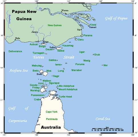
A map of the Torres Strait Islands. I have endeavoured to use native names wherever I could find them. If you can suggest ways in which this map could be made more up to date, don't hesitate to leave me a message to that effect.
This map's source is here, with the uploader's modifications, and the GMT homepage says that the tools are released under the GNU General Public License.
The original description page was here. All following user names refer to en.wikipedia.
2006-04-19 00:55 Kelisi 929×922×8 (28510 bytes)
2006-04-18 03:38 Kelisi 929×922×8 (28133 bytes) A map of the Torres Strait Islands. I have endeavoured to use native names wherever I could find them. If you can suggest ways in which this map could be made more up to date, don't hesitate to leave me a message to that effect. This map's source is [htt
{{Information |Description=A map of the Torres Strait Islands. I have endeavoured to use native names wherever I could find them. If you can suggest ways in which this map could be made more up to date, don't hesitate to leave me a message to that effect.
ไฟล, torresstraitislandsmap, ไฟล, ประว, ไฟล, หน, าท, ภาพน, การใช, ไฟล, วนกลาง, อม, ลเก, ยวก, บภาพขนาดของต, วอย, างน, กเซล, ความละเอ, ยดอ, กเซล, กเซล, กเซล, ภาพท, ความละเอ, ยดส, งกว, 8206, กเซล, ขนาดไฟล, โลไบต, ชน, ดไมม, image, ปภาพหร, อไฟล, เส, ยงน, นฉบ, บอย, . ifl prawtiifl hnathimiphaphni karichiflswnklang khxmulekiywkbphaphkhnadkhxngtwxyangni 604 599 phikesl khwamlaexiydxun 242 240 phikesl 484 480 phikesl 929 922 phikesl duphaphthimikhwamlaexiydsungkwa 8206 929 922 phikesl khnadifl 28 kiolibt chnidimm image png rupphaphhruxiflesiyngni tnchbbxyuthi khxmmxns raylaexiyddanlang epnkhxkhwamthiaesdngphlcak ifltnchbbinkhxmmxns khxmmxnsepnewbistinokhrngkarsahrbekbrwbrwmsuxesri thi khunsamarthchwyid khwamyx phaphaephnthirabutaaehnngni khwrcathuksrangihmepnkrafiksewketxr sungmikhxdixikhlayprakar duephimetimthikhxmmxns suxtxngkarekbkwadsahrbsarsnethsephimetim hakphaphnimiinrupaebbkrafiksewketxrxyuaelw krunaxpohldaelaaethnthiaemaebbnidwy vector version available i chuxphaphihm i aenanaepnxyangyingihtngchuxiflewketxrihmnninrupaebb TorresStraitIslandsMap svg aelwisaemaebb Vector version available hrux Vva sungimtxngichpharamietxr chuxphaphihm khaxthibayTorresStraitIslandsMap png A map of the Torres Strait Islands I have endeavoured to use native names wherever I could find them If you can suggest ways in which this map could be made more up to date don t hesitate to leave me a message to that effect This map s source is here with the uploader s modifications and the GMT homepage says that the tools are released under the GNU General Public License wnthi 18 emsayn ph s 2549 original upload date aehlngthima naekhacak en wikipedia mayngkhxmmxns phusrangsrrkh Kelisi thi wikiphiediyphasaxngkvs ewxrchnxun Image TorresStraitIslandsMap zh png karxnuyatichsiththi Kelisi cakwikiphiediyphasaxngkvs inthanaphuthuxlikhsiththikhxngphaphhruxsuxni xnuyatihichphaphhruxsuxniphayitenguxnikhtxipni iflnixyuphayitsyyaxnuyat khriexthifkhxmmxns aebbaesdngthima xnuyataebbediywkn 3 0 tnchbb thngni epniptamkhxptiesthkhwamrbphidchxb karaesdngthima Kelisi cakwikiphiediyphasaxngkvs khunsamarth thicaaebngpn thicathasaena aeckcay aelasngngandngklawtxip thicaeriyberiyngihm thicaddaeplngngandngklaw phayitenguxnikhtxipni aesdngthima khuntxngihekiyrtiecakhxngnganxyangehmaasm odyephimlingkipyngsyyaxnuyat aelarabuhakmikarepliynaeplng khunxacthaechnniidinrupaebbidkidtamkhwr aettxngimichinlksnathiaenawaphuihxnuyatsnbsnunkhunhruxkarichngankhxngkhun xnuyataebbediywkn hakkhunddaeplng epliynrup hruxtxetimnganni khuntxngichsyyaxnuyataebbediywknhruxaebbthiehmuxnkbsyyaxnuyatthiichkbnganniethann payaesdngsthanalikhsiththinithukephimephuxihepniptamkarepliynaeplngsyyaxnuyatkhxngmulnithiwikimiediy cak GFDL ipyng GFDL khwbkhukb CC BY SA 3 0 http creativecommons org licenses by sa 3 0 CC BY SA 3 0 Creative Commons Attribution Share Alike 3 0 true true xnuyatihkhdlxk aeckcayaela hruxddaeprexksarniphayitenguxnikhkhxngsyyaxnuyatexksaresrikhxngknu run 1 2 hruxrunid nbcaknithixxkodymulnithisxftaewresri odyimmiswnidhamaekikh immikhxkhwampkhnaaelapkhlng saenakhxngsyyaxnuyatrwmxyuinswnchux syyaxnuyatexksaresrikhxngknu thngni epniptamkhxptiesthkhwamrbphidchxbhttp www gnu org copyleft fdl html GFDL GNU Free Documentation License true true bnthukkarxphohld The original description page was here All following user names refer to en wikipedia 2006 04 19 00 55 Kelisi 929 922 8 28510 bytes 2006 04 18 03 38 Kelisi 929 922 8 28133 bytes A map of the Torres Strait Islands I have endeavoured to use native names wherever I could find them If you can suggest ways in which this map could be made more up to date don t hesitate to leave me a message to that effect This map s source is httkhabrryayodyyxithyephimkhabrryaythrrthdediywephuxkhyaykhwamwaiflnimixairxahrbجزر مضيق توريسixethmthiaesdngxyuiniflniprakxbdwysthanalikhsiththimilikhsiththisyyaxnuyatGNU Free Documentation License version 1 2 or later nbsp xngkvsCreative Commons Attribution ShareAlike 3 0 Unported nbsp xngkvswnthisrang wnkxtng18 emsayn 2006MIME type nbsp xngkvsimage png prawtiifl khlikwnthi ewlaephuxduiflthipraktinkhnann wnthi ewlarupyxkhnadphuichkhwamehn pccubn13 42 13 mkrakhm 2565929 922 28 kiolibt KelisiReverted to version as of 00 09 1 May 2007 UTC Hardly those two colours are closer to each other 00 59 7 tulakhm 2564929 922 31 kiolibt Claude ZygielBetter contrast 07 09 1 phvsphakhm 2550929 922 28 kiolibt Stanmar Information Description A map of the Torres Strait Islands I have endeavoured to use native names wherever I could find them If you can suggest ways in which this map could be made more up to date don 039 t hesitate to leave me a message to that effect hnathimiphaphni hnatxipni oyngmathiphaphni chxngaekhbthxrers karichiflswnklang wikixuntxipniichiflni karichbn af wikipedia org Straat van Torres eilande karichbn als wikipedia org Melanesien Torres Strasse karichbn ar wikipedia org مضيق توريس قناة أدولفوس جزر مضيق توريس karichbn azb wikipedia org اوسترالیا یئرلیلری karichbn bar wikipedia org Melanesien karichbn ba wikipedia org Torres bogaҙy karichbn bg wikipedia org Toresov protok karichbn bn wikipedia org টর স প রণ ল karichbn br wikipedia org Strizh mor Torres karichbn ca wikipedia org Estret de Torres Illes de l estret de Torres karichbn ceb wikipedia org Torres Strait Islands Endeavour Strait karichbn cs wikipedia org Luis Vaez de Torres Torresuv pruliv Ostrovy Torresova prulivu Endeavour pruliv karichbn cy wikipedia org Ynysoedd Culfor Torres karichbn da wikipedia org Torres Strait O folket Torresstraedet karichbn de wikipedia org Torres Strasse Prince of Wales Insel Queensland Torres Straits Expedition Bellevue Inseln Mabuiag Talbot Inseln Boigu Flagge der Torres Strait Insulaner Manar Inseln Thursday Island Horn Island Torres Strait Saibai Thursday Inseln The Three Sisters Torres Strait Dauan Bet Island Poll Island Sue Island Murray Inseln Murray Island Badu Island Moa Island Coconut Island Australien Yam Island Hammond Island Goods Island Friday Island Torres Strait dukarichthwolkephimetimkhxngiflnikhxmulekiywkbphaph phaphnimikhxmulephimetim sungswnihymacakklxngdicitxlhruxsaeknenxrthisamarthekbkhxmuldngklawiwrwmkbphaphid thaphaphnithukprbprungaekikhhruxepliynaeplngcakedim khxmulbangxyangcayngkhngimepliynaeplngehmuxnphaphthithukprbprungaekikhnnaekikhphaphlasud01 54 19 emsayn 2549 ekhathungcak https th wikipedia org wiki ifl TorresStraitIslandsMap png, wikipedia, วิกิ หนังสือ, หนังสือ, ห้องสมุด,