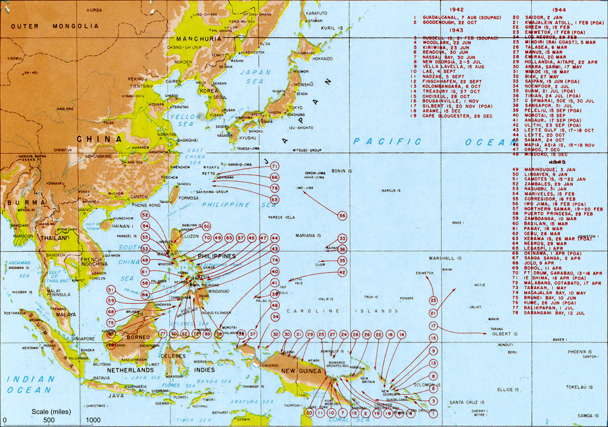
Map titled "Allied landings — August 1942 to August 1945", plate #126. It should be noted that while the title of the image is "US Landings" the map also indicates the position of many landings by Australian troops (at least) so should be referred to as "Allied landings".
วันที่
circa พ.ศ. 2493
date QS:P,+1950-00-00T00:00:00Z/9,P1480,Q5727902
แหล่งที่มา
MacArthur, Douglas (พ.ศ. 2537) [พ.ศ. 2493] Reports of General MacArthur, Vol. 1, Center of Military History, pp. p. 432 Retrieved on 24 กุมภาพันธ์ พ.ศ. 2552.
ผู้สร้างสรรค์
General MacArthur's General Staff
การอนุญาต (การใช้ไฟล์นี้ใหม่)
Public domainPublic domainfalsefalse
เวอร์ชันอื่น
ไฟล์อื่นที่ใช้ไฟล์นี้: US landings saipan.jpg
ภาพแผนที่ทางทหารนี้ ควรจะถูกสร้างใหม่เป็นกราฟิกส์เวกเตอร์ ซึ่งมีข้อดีอีกหลายประการ ดูเพิ่มเติมที่คอมมอนส์:สื่อต้องการเก็บกวาดสำหรับสารสนเทศเพิ่มเติม หากภาพนี้มีในรูปแบบกราฟิกส์เวกเตอร์อยู่แล้ว กรุณาอัปโหลดและแทนที่แม่แบบนี้ด้วย {{vector version available|ชื่อภาพใหม่}} แนะนำเป็นอย่างยิ่งให้ตั้งชื่อไฟล์เวกเตอร์ใหม่นั้นในรูปแบบ "US landings.svg" แล้วใส่แม่แบบ Vector version available (หรือ Vva) ซึ่งไม่ต้องใช้พารามิเตอร์ ชื่อภาพใหม่
This military map image was uploaded in the JPEG format even though it consists of non-photographic data. This information could be stored more efficiently or accurately in the PNG or SVG format. If possible, please upload a PNG or SVG version of this image without compression artifacts, derived from a non-JPEG source (or with existing artifacts removed). After doing so, please tag the JPEG version with {{Superseded|NewImage.ext}} and remove this tag. This tag should not be applied to photographs or scans. For more information, see {{BadJPEG}}.
Transfer log
Transfered from Wikipedia image of same name. Text above copied from Wikipedia. Performed by Mak 21:58, 29 May 2006 (UTC)
Allied landings - August 1942 to August 1945 Source: Scanned from Reports of General MacArthur (1994 facsimile printing), Vol 1. Plate #126 Category:World War II (pacific) Category: WWII maps (Pacific) License: Official US government document -
ไฟล, landings, ไฟล, ประว, ไฟล, หน, าท, ภาพน, การใช, ไฟล, วนกลาง, อม, ลเก, ยวก, บภาพขนาดของต, วอย, างน, กเซล, ความละเอ, ยดอ, กเซล, กเซล, กเซล, กเซล, กเซล, ภาพท, ความละเอ, ยดส, งกว, 8206, กเซล, ขนาดไฟล, เมกะไบต, ชน, ดไมม, image, jpeg, ปภาพหร, อไฟล, เส, ยงน, นฉบ,. ifl prawtiifl hnathimiphaphni karichiflswnklang khxmulekiywkbphaphkhnadkhxngtwxyangni 800 562 phikesl khwamlaexiydxun 320 225 phikesl 640 449 phikesl 1 024 719 phikesl 1 280 899 phikesl 1 995 1 401 phikesl duphaphthimikhwamlaexiydsungkwa 8206 1 995 1 401 phikesl khnadifl 1 11 emkaibt chnidimm image jpeg rupphaphhruxiflesiyngni tnchbbxyuthi khxmmxns raylaexiyddanlang epnkhxkhwamthiaesdngphlcak ifltnchbbinkhxmmxns khxmmxnsepnewbistinokhrngkarsahrbekbrwbrwmsuxesri thi khunsamarthchwyid khaxthibayUS landings jpg Map titled Allied landings August 1942 to August 1945 plate 126 It should be noted that while the title of the image is US Landings the map also indicates the position of many landings by Australian troops at least so should be referred to as Allied landings wnthi circa ph s 2493 date QS P 1950 00 00T00 00 00Z 9 P1480 Q5727902aehlngthima MacArthur Douglas ph s 2537 ph s 2493 Reports of General MacArthur Vol 1 Center of Military History pp p 432 Retrieved on 24 kumphaphnth ph s 2552 phusrangsrrkh General MacArthur s General Staffkarxnuyat karichiflniihm Public domain Public domain false falsephaphhruxsuxtxipnithayhruxcdthakhuninrahwangkarptibtihnathirachkarkhxngkharachkarpracakxngthphshrthxemrika hruxkharachkarpracakrathrwngklaohmshrthxemrika phaphhruxsuxdngklawcungcdepnngankhxngrthbalklangshrthxemrika aelathuxepnsatharnsmbtiduephimthi http www defenselink mil multimedia about html العربية catala cestina Deutsch Ellhnika English espanol eesti فارسی suomi francais galego ह न द hrvatski magyar italiano 日本語 한국어 makedonski മലയ ള Malti Nederlands polski portugues portugues do Brasil romană russkij sicilianu slovencina slovenscina srpski srpski ithy Turkce ukrayinska Tiếng Việt 中文 中文 简体 中文 繁體 ewxrchnxun iflxunthiichiflni US landings saipan jpg phaphaephnthithangthharni khwrcathuksrangihmepnkrafiksewketxr sungmikhxdixikhlayprakar duephimetimthikhxmmxns suxtxngkarekbkwadsahrbsarsnethsephimetim hakphaphnimiinrupaebbkrafiksewketxrxyuaelw krunaxpohldaelaaethnthiaemaebbnidwy vector version available i chuxphaphihm i aenanaepnxyangyingihtngchuxiflewketxrihmnninrupaebb US landings svg aelwisaemaebb Vector version available hrux Vva sungimtxngichpharamietxr chuxphaphihmThis military map image was uploaded in the JPEG format even though it consists of non photographic data This information could be stored more efficiently or accurately in the PNG or SVG format If possible please upload a PNG or SVG version of this image without compression artifacts derived from a non JPEG source or with existing artifacts removed After doing so please tag the JPEG version with Superseded NewImage ext and remove this tag This tag should not be applied to photographs or scans For more information see BadJPEG Transfer log Transfered from Wikipedia image of same name Text above copied from Wikipedia Performed by Mak 21 58 29 May 2006 UTC prawtiifl khlikwnthi ewlaephuxduiflthipraktinkhnann wnthi ewlarupyxkhnadphuichkhwamehn pccubn01 51 22 kumphaphnth 25531 995 1 401 1 11 emkaibt Raul654Added scale to map using Darwin Makassar distance as 925 miles per web sources 12 31 24 kumphaphnth 25521 995 1 401 1 37 emkaibt JappalangClearer map taken from the US Army site 04 58 30 phvsphakhm 25492 000 1 363 437 kiolibt MakthorpeAllied landings August 1942 to August 1945 Source Scanned from Reports of General MacArthur 1994 facsimile printing Vol 1 Plate 126 Category World War II pacific Category WWII maps Pacific License Official US government document hnathimiphaphni hnatxipni oyngmathiphaphni sngkhramaepsifik karichiflswnklang wikixuntxipniichiflni karichbn ar wikipedia org استسلام اليابان حرب المحيط الهادئ karichbn ast wikipedia org Rindicion de Xapon karichbn azb wikipedia org ایکینجی دۆنیا ساواش سینده ساکیت اوقیانوس جبهه سی karichbn az wikipedia org Vikipediya Heftenin yaxsi meqalesi 5 Hefte 2016 Vikipediya Heftenin yaxsi meqalesi fevral 2016 karichbn bg wikipedia org Tihookeanski teatr Vtora svetovna vojna karichbn bjn wikipedia org Manyarahnya Japang karichbn br wikipedia org Brezel ar Meurvor Habask 1937 1945 karichbn bs wikipedia org Rat na Pacifiku Sablon Istaknuti clanak juni2009 karichbn ca wikipedia org Guerra del Pacific karichbn cs wikipedia org Druha svetova valka v Tichomori karichbn da wikipedia org Stillehavskrigen Japans kapitulation karichbn el wikipedia org Polemos toy Eirhnikoy karichbn en wikipedia org User Gdr 3rd party images Surrender of Japan Joint Army Navy Assessment Committee User G bilbao susana sandbox Infobox Military conflict User Bangkok31 subpage karichbn es wikipedia org Rendicion de Japon karichbn et wikipedia org Soda Vaiksel ookeanil karichbn eu wikipedia org Pazifikoko Gerra karichbn fa wikipedia org جنگ اقیانوس آرام karichbn fi wikipedia org Tyynenmeren sota toisessa maailmansodassa karichbn fr wikipedia org Seconde Guerre mondiale Discussion Guerre du Pacifique Discussion utilisateur Archeos Discussions de salle de redaction Discussion Projet Seconde Guerre mondiale Archive 2006 Discussion utilisateur Lilliputien Renseignements generaux RAZ Discussion Projet Histoire militaire Archive 2006 Utilisateur Pontauxchats Archives Pontauxchats 9 Discussion utilisateur L amateur d aeroplanes Archive1 Discussion Projet Seconde Guerre mondiale Archive 1 Capitulation du Japon karichbn ha wikipedia org Yakin Pacific karichbn he wikipedia org המערכה באסיה ובאוקיינוס השקט karichbn hr wikipedia org Rat na Pacifiku Wikipedija Izabrani clanci 2010 Wikipedija Izabrani clanci 31 2010 karichbn hu wikipedia org Japan kapitulacioja karichbn hy wikipedia org Վիքիպեդիա Օրվա հոդված Հուլիս 2017 թ Խաղաղօվկիանոսյան պատերազմ Կաղապար Օրվա հոդված Հուլիսի 5 2017 թ karichbn id wikipedia org Menyerahnya Jepang karichbn it wikipedia org Resa del Giappone karichbn ka wikipedia org იაპონიის კაპიტულაცია karichbn lt wikipedia org Karas Ramiajame vandenyne karichbn ml wikipedia org പസഫ ക യ ദ ധ dukarichthwolkephimetimkhxngiflnikhxmulekiywkbphaph phaphnimikhxmulephimetim sungswnihymacakklxngdicitxlhruxsaeknenxrthisamarthekbkhxmuldngklawiwrwmkbphaphid thaphaphnithukprbprungaekikhhruxepliynaeplngcakedim khxmulbangxyangcayngkhngimepliynaeplngehmuxnphaphthithukprbprungaekikhnn error0 ekhathungcak https th wikipedia org wiki ifl US landings jpg, wikipedia, วิกิ หนังสือ, หนังสือ, ห้องสมุด,