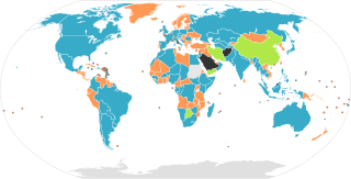
Map of the legislative organizations of the countries of the world, originally by Aris Katsaris. Note: This only shows national legislatures, federations with sublegislatures are not required to have sublegislatures on the same model as their country: The United States has a bicameral legislature, the State of Nebraska has a unicameral legislature. Similarly, although Canada has a bicameral legislature, all of its provinces and territories have unicameral legislatures. Note: Any official "legislature", including unelected and powerlessly limited ones, are counted. Countries without a functioning legislature, such as countries governed by a military junta, are coloured black.
2007-06-19T16:31:05Z Gadren 1262x628 (46103 Bytes) == Summary == Map of unicameral and bicameral parliaments around the world. Created by [[:en:User:Aris Katsaris|Aris Katsaris]]. Orange is for unicameral, blue is for bicameral and gray is neither. == Licensing == {{GFDL-use
2007-05-05T18:17:47Z Gadren 1262x628 (46144 Bytes) Map of unicameral and bicameral parliaments around the world. Created by [[:en:User:Aris Katsaris|Aris Katsaris]]. Orange is for unicameral, blue is for bicameral and gray is neither.
2006-04-23T21:37:14Z Metarhyme 1262x628 (46084 Bytes) == Summary == Map of unicameral and bicameral parliaments around the world. Created by [[:en:User:Aris Katsaris|Aris Katsaris]]. Orange is for unicameral, blue is for bicameral and gray is neither. == Licensing == {{GFDL-use
2005-11-11T21:57:05Z Moyogo 1262x628 (27224 Bytes) fixed DR Congo
2005-10-06T07:06:09Z Gabbe 1262x628 (27124 Bytes) Fix Kalimantan
2005-10-05T21:10:43Z Gabbe 1262x628 (27137 Bytes) fixed Indonesia
2005-10-04T07:03:25Z Gabbe 1262x628 (27151 Bytes) Map of unicameral and bicameral parliaments around the world. Created by [[:en:User:Aris Katsaris|Aris Katsaris]].
2005-09-05T06:04:29Z Gabbe 1262x628 (27060 Bytes) Map of unicameral and bicameral parliaments around the world. Created by [[en:User:Aris Katsaris|]].
File:BlankMap-World6.svg licensed with PD-self
2009-06-13T16:59:33Z NuclearVacuum 940x477 (1671030 Bytes) fixed the global outline on my upload
2009-06-13T16:55:42Z NuclearVacuum 940x477 (1671080 Bytes) Similar to how Serbia and Kosovo are separated, I made the outline for Abkhazia, South Ossetia, and Transnistria
2009-03-20T01:00:21Z AzaToth 940x477 (1605234 Bytes) Fix errorious duplicate end tag of id='ma'/> Specified style, dc:format, and dc:title tag to be CDATA
2009-03-19T23:57:36Z AzaToth 940x477 (1605207 Bytes) Fix duplicate ID (was two "mf", changed second to "mf-")
2009-01-23T13:36:09Z Yug 940x477 (1605206 Bytes) The English colours are controversial: ink consuming, not print friendly [black&white], CIA based.
2009-01-19T18:37:07Z Emilfaro 940x477 (1605212 Bytes) CSS edited to bring in accordance with [[:en:Wikipedia:WikiProject Maps]] Standard convention on the Map colors.
2008-11-02T02:13:36Z Lokal Profil 940x477 (1605206 Bytes) Reverted to version as of 00:30, 29 March 2008. This version includes metadata about title and license of image. The SVG validator is broken with regards to metadata (and other thing) see [[:Template talk:ValidSVG]] for more
2008-03-29T00:30:24Z Canuckguy 940x477 (1605206 Bytes) fixed error found: Sao Tome (code "st") was messing with the coast tag ("coast" ends in "st") on some maps. Changed "land", "coast", "circle" and "sub" tags to "landxx", "coastxx", "circlexx" and "subxx" to prevent further
2008-02-27T21:20:02Z Canuckguy 940x477 (1602296 Bytes) make borders touch, add circles for French DOMs and Chinese SARs, undo rounding of numbers, delete some extraneous nodes.
2008-02-02T18:38:58Z AzaToth 940x477 (881503 Bytes) rounding the values to near whole numbers. I don't think the decimals will do any visible difference at all.
2007-12-14T02:57:29Z Lokal Profil 940x477 (1616830 Bytes) a class fix to France. Moved the france group further down to not cover andorra circle etc. Got rid of som translate tags by recalculating the paths.
2007-12-09T20:27:34Z Canuckguy 940x477 (1616719 Bytes) thinner line for borders
2007-12-09T03:58:49Z Canuckguy 940x477 (1616984 Bytes) changes to France (see description and discussion pages), added a class for islands without an international border that makes the coastline thinner
2007-11-08T22:20:44Z Ketiltrout 940x477 (1614834 Bytes) Move Disko Island and the Bahamas back to their rightful places
2007-09-25T02:52:30Z Canuckguy 940x477 (1631712 Bytes) Moved css classes around and added a few additional instructions in the css for colouring the map. Fixed a few errors that were reverted.
2007-09-17T22:06:35Z Lokal Profil 940x477 (1632888 Bytes) aq_land (and arctic) to aq, removed two formating cludges which didn't make any visual difference, Replaced swaziland by formating cludge around swaziland and renamed, removed duplicat "ki" entry (probably left by me last tim
2007-09-13T18:52:32Z Lokal Profil 940x477 (1635420 Bytes) Basically same edits as Canuckguy but in a text editor so as to eliminate Inksacape junk code and preserve the style structure. Also made sure all circles are above the surrounding countries.
2007-09-10T05:54:39Z Canuckguy 940x477 (1915635 Bytes) Simplified circles - now in same layer as countries (making the whole file one layer), simplified a few other things as detailed on the changes in the descrption on the talk page.
2007-09-09T03:03:49Z Lokal Profil 940x477 (1632593 Bytes) Added ISO-id to Mongolia, Bhutan and Andorra circle, Corrected id of Malawi, made "Swaziland border path" transparent so that colour of underlying path becomes visible. Also removed Inkscape objects, cleaned out a lot of blan
2007-08-29T21:14:30Z H2g2bob 940x477 (1630393 Bytes) Remove class="..." from elements if parent has same or similar class, allowing for inheritance of style rules.
2007-08-25T22:15:44Z H2g2bob 940x477 (1686400 Bytes) Update to map to include styles in CSS stylesheet using <svg:style> tags. This allows changing the style of the entire map in one go. This edit was done in a text editor.
2007-08-22T00:27:08Z Canuckguy 940x477 (2019787 Bytes) fixed a few problems with previous version (restored small countries circles, fixed problem with Germany and Serbia)
2007-07-08T21:00:39Z Andrew pmk 940x477 (2021488 Bytes) Remove lots of small islands which are not visible or barely visible at normal zoom levels; clean up borders so that boundaries are included in the main country groups, rather than being separate objects; make background all
2007-07-04T00:04:59Z AzaToth 940x477 (2265956 Bytes) Minor optimizations using perl SVG::Parser and SVG modules (reparsing the tree)
2007-01-09T03:38:38Z Roke 940x477 (2370958 Bytes) Reverted to earlier revision
2007-01-09T03:37:25Z Roke 940x477 (2549763 Bytes) hidden layers: separate non-sovereign & sovereign circles, text
2006-12-10T10:34:46Z Brianski 940x477 (2209317 Bytes) re-optimized with optisvg.pl
2006-11-26T06:54:55Z Canuckguy 940x477 (2370957 Bytes) deleted Aksai Chin, awarded territory to China (nation of control, as India is pictured as the nation of control over Arunchal Pradesh). Revised from previous version by me, so may need optimizing by Brianski's tool again (s
2006-11-23T11:27:06Z Brianski 940x477 (2273821 Bytes) optimized using Brian Szymanski's optisvg.pl
2006-11-21T23:09:04Z Canuckguy 940x477 (2440482 Bytes) a few more minor tweaks
2006-11-12T04:13:48Z Hexagon1 940x477 (2365940 Bytes) Canuckguy's fixed some errors
2006-11-12T02:02:50Z Hexagon1 940x765 (2318315 Bytes) Detailed SVG map with grouping enabled to connect all non-contiguous parts of a country's territory for easy colouring.
China is a nation with an unicameral legislature and an advisory body.(see Chinese People's Political Consultative Conference & National People's Congress) HK and Macao are literally Special Administrative Regions (SAR, provincial-level) under Beijing, whose legislatures are not national.(see 2017 National People's Congress election in Hong Kong)
Botswana is not unambiguously Bicameral and Iran is not unambiguously Unicameral. Both the Iranian Assembly of Experts and the Motswana House of Chiefs are advisory bodies to the Parliament that are ambiguously upper houses.
ไฟล, unibicameral, ไฟล, ประว, ไฟล, หน, าท, ภาพน, การใช, ไฟล, วนกลาง, อม, ลเก, ยวก, บภาพขนาดของต, วอย, าง, ของไฟล, กเซล, ความละเอ, ยดอ, กเซล, กเซล, กเซล, กเซล, กเซล, กเซล, ภาพท, ความละเอ, ยดส, งกว, 8206, ไฟล, กเซล, ขนาดไฟล, เมกะไบต, ปภาพหร, อไฟล, เส, ยงน, นฉบ, . ifl prawtiifl hnathimiphaphni karichiflswnklang khxmulekiywkbphaphkhnadkhxngtwxyang PNG nikhxngifl SVG ni 800 406 phikesl khwamlaexiydxun 320 162 phikesl 640 325 phikesl 1 024 520 phikesl 1 280 650 phikesl 2 560 1 299 phikesl 940 477 phikesl duphaphthimikhwamlaexiydsungkwa 8206 ifl SVG 940 477 phikesl khnadifl 1 64 emkaibt rupphaphhruxiflesiyngni tnchbbxyuthi khxmmxns raylaexiyddanlang epnkhxkhwamthiaesdngphlcak ifltnchbbinkhxmmxns khxmmxnsepnewbistinokhrngkarsahrbekbrwbrwmsuxesri thi khunsamarthchwyid i sxrsokhdkhxng SVG nitrwcsxbthuktxngaelw khaxthibayUnibicameral Map svg Map of the legislative organizations of the countries of the world originally by Aris Katsaris Note This only shows national legislatures federations with sublegislatures are not required to have sublegislatures on the same model as their country The United States has a bicameral legislature the State of Nebraska has a unicameral legislature Similarly although Canada has a bicameral legislature all of its provinces and territories have unicameral legislatures Note Any official legislature including unelected and powerlessly limited ones are counted Countries without a functioning legislature such as countries governed by a military junta are coloured black wnthi 22 mithunayn ph s 2552 11 39 UTC aehlngthima Unibicameral Map png BlankMap World6 svgphusrangsrrkh Unibicameral Map png Aris Katsaris BlankMap World6 svg en User Canuckguy SkyBonTalkContributions derivative work Cerveaugenie Legend English en Map of nations based on their legislatures Nations with a unicameral form of legislature Nations with a unicameral legislature and an advisory body Nations with a bicameral form of legislature Nations with no form of legislature Data not available العربية ar خريطة الدول بناء على برلماناتها دول لديها برلمان بغرفة واحدة دول لديها برلمان من مجلسين دول ليس لديها برلمان البيانات غير متوفرة فارسی fa نقشه نهادهای قانون گذار جهان بر پایه نظام مجلس نهاد قانون گذاری تک مجلسی نهاد قانون گذاری دومجلسی نهاد قانون گذاری تک مجلسی و یک نهاد مشورتی بی مجلس بی داده russkij Ru Zakonodatelnaya vlast Odnopalatnye parlamenty Odnopalatnye parlamenty s konsultativnym organom Dvuhpalatnye parlamenty Parlament otsutstvuet Net dannyh Deutsch de Staaten und ihre Legislative Staaten mit Einkammersystem Staaten mit Einkammersystem und Beratungsorgan Staaten mit Zweikammersystem Staaten ohne Legislative Ohne Daten francais fr Une carte des pays basee sur leurs systemes parlementaires Pays avec un parlement monocameral Pays avec un parlement bicameral Pays sans forme de parlement Donnees non disponibles makedonski mk Karta na drzhavite spored vidot na zakonodavniot dom Drzhavi so ednodomno sobranie Drzhavi so dvodomno sobranie Drzhavi bez formalen zakonodaven dom Nema podatoci Nederlands nl Kaart met landen gebaseerd op hun parlementssysteem Landen met een eenkamerstelsel Landen met een eenkamerstelsel en een adviesorgaan Landen with a tweekamerstelsel Landen zonder vorm van parlement Gegevens niet beschikbaar espanol es Mapa de naciones basado en legislaciones Naciones con legislacion unicameral Naciones con legislacion unicameral y un consejo consultivo Naciones con legislacion bicameral Naciones sin ninguna forma de legislacion Informacion no disponible italiano it Mappa dei sistemi parlamentari nel mondo Nazioni con parlamento unicamerale Nazioni con parlamento bicamerale Nazioni senza parlamento Dati non disponibili dansk da Kort over verdens lande baseret pa deres parlamenter Nationer med et etkammersystem Nationer med et tokammersystem Nationer uden et parlament Intet data tilgaengeligt magyar hu Vilagterkep az allamok torvenyhozasa szerint Allamok egykamaras torvenyhozassal Allamok ketkamaras torvenyhozassal Allamok torvenyhozasi forma nelkul nincs adat catala ca Mapa d estats segons llurs organs legislatius Estats monocamerals Estats monocamerals que compten amb un organ consultiu Estats bicamerals Estats sense organ legislatiu Sense dades Turkce tr Milletlerin yasama organlarina gore haritasi Tek meclisli sisteme sahip devletler Tek meclisli bir sistem ve bir danisma organi olan devletler Cift meclisli sisteme sahip devletler Yasama organi olmayan devletler Verisiz xnuyatihkhdlxk aeckcayaela hruxddaeprexksarniphayitenguxnikhkhxngsyyaxnuyatexksaresrikhxngknu run 1 2 hruxrunid nbcaknithixxkodymulnithisxftaewresri odyimmiswnidhamaekikh immikhxkhwampkhnaaelapkhlng saenakhxngsyyaxnuyatrwmxyuinswnchux syyaxnuyatexksaresrikhxngknuhttp www gnu org copyleft fdl html GFDL GNU Free Documentation License true trueiflnixyuphayitsyyaxnuyat khriexthifkhxmmxns aebbaesdngthima xnuyataebbediywkn 3 0 tnchbbkhunsamarth thicaaebngpn thicathasaena aeckcay aelasngngandngklawtxip thicaeriyberiyngihm thicaddaeplngngandngklaw phayitenguxnikhtxipni aesdngthima khuntxngihekiyrtiecakhxngnganxyangehmaasm odyephimlingkipyngsyyaxnuyat aelarabuhakmikarepliynaeplng khunxacthaechnniidinrupaebbidkidtamkhwr aettxngimichinlksnathiaenawaphuihxnuyatsnbsnunkhunhruxkarichngankhxngkhun xnuyataebbediywkn hakkhunddaeplng epliynrup hruxtxetimnganni khuntxngichsyyaxnuyataebbediywknhruxaebbthiehmuxnkbsyyaxnuyatthiichkbnganniethannpayaesdngsthanalikhsiththinithukephimephuxihepniptamkarepliynaeplngsyyaxnuyatkhxngmulnithiwikimiediy cak GFDL ipyng GFDL khwbkhukb CC BY SA 3 0 http creativecommons org licenses by sa 3 0 CC BY SA 3 0 Creative Commons Attribution Share Alike 3 0 true truebnthukkarxphohld This image is a derivative work of the following images File Unibicameral Map png licensed with GFDL en GFDL user en note 2009 06 08T11 46 57Z Middayexpress 1262x628 17539 Bytes updated 2009 06 08T11 45 29Z Middayexpress 1262x628 17539 Bytes Updated 2009 04 18T12 49 18Z SeNeKa 1262x628 17534 Bytes updated 2009 04 18T09 53 11Z SeNeKa 1262x628 16784 Bytes Updated 2007 06 19T16 31 05Z Gadren 1262x628 46103 Bytes Summary Map of unicameral and bicameral parliaments around the world Created by en User Aris Katsaris Aris Katsaris Orange is for unicameral blue is for bicameral and gray is neither Licensing GFDL use 2007 05 05T18 17 47Z Gadren 1262x628 46144 Bytes Map of unicameral and bicameral parliaments around the world Created by en User Aris Katsaris Aris Katsaris Orange is for unicameral blue is for bicameral and gray is neither 2006 06 22T22 13 33Z Nightstallion 1262x628 46090 Bytes slovenia s bicameral 2006 04 23T21 37 14Z Metarhyme 1262x628 46084 Bytes Summary Map of unicameral and bicameral parliaments around the world Created by en User Aris Katsaris Aris Katsaris Orange is for unicameral blue is for bicameral and gray is neither Licensing GFDL use 2006 02 13T06 02 50Z Jaranda 1262x628 46191 Bytes 2005 11 11T21 57 05Z Moyogo 1262x628 27224 Bytes fixed DR Congo 2005 10 06T07 06 09Z Gabbe 1262x628 27124 Bytes Fix Kalimantan 2005 10 05T21 10 43Z Gabbe 1262x628 27137 Bytes fixed Indonesia 2005 10 04T07 03 25Z Gabbe 1262x628 27151 Bytes Map of unicameral and bicameral parliaments around the world Created by en User Aris Katsaris Aris Katsaris 2005 09 05T06 04 29Z Gabbe 1262x628 27060 Bytes Map of unicameral and bicameral parliaments around the world Created by en User Aris Katsaris File BlankMap World6 svg licensed with PD self 2009 06 13T16 59 33Z NuclearVacuum 940x477 1671030 Bytes fixed the global outline on my upload 2009 06 13T16 55 42Z NuclearVacuum 940x477 1671080 Bytes Similar to how Serbia and Kosovo are separated I made the outline for Abkhazia South Ossetia and Transnistria 2009 05 13T13 58 14Z SkyBon 940x477 1601527 Bytes fixed 2009 05 13T03 24 33Z Unionhawk 940x477 1605234 Bytes Reverted to version as of 01 00 20 March 2009 2009 05 12T15 39 38Z SkyBon 940x477 1601502 Bytes oops 2009 05 12T15 38 35Z SkyBon 477x940 1601502 Bytes code cleanup 2009 03 20T01 00 21Z AzaToth 940x477 1605234 Bytes Fix errorious duplicate end tag of id ma gt Specified style dc format and dc title tag to be CDATA 2009 03 19T23 57 36Z AzaToth 940x477 1605207 Bytes Fix duplicate ID was two mf changed second to mf 2009 01 23T13 36 09Z Yug 940x477 1605206 Bytes The English colours are controversial ink consuming not print friendly black amp white CIA based 2009 01 19T18 37 07Z Emilfaro 940x477 1605212 Bytes CSS edited to bring in accordance with en Wikipedia WikiProject Maps Standard convention on the Map colors 2008 11 02T02 13 36Z Lokal Profil 940x477 1605206 Bytes Reverted to version as of 00 30 29 March 2008 This version includes metadata about title and license of image The SVG validator is broken with regards to metadata and other thing see Template talk ValidSVG for more 2008 11 02T01 32 33Z Victormoz 940x477 1601613 Bytes 2008 11 02T01 28 12Z Victormoz 940x477 1601629 Bytes 2008 11 02T01 14 36Z Victormoz 940x477 1601705 Bytes 2008 03 29T00 30 24Z Canuckguy 940x477 1605206 Bytes fixed error found Sao Tome code st was messing with the coast tag coast ends in st on some maps Changed land coast circle and sub tags to landxx coastxx circlexx and subxx to prevent further 2008 02 28T03 55 15Z Canuckguy 940x477 1604123 Bytes re added missing Honduras 2008 02 27T21 20 02Z Canuckguy 940x477 1602296 Bytes make borders touch add circles for French DOMs and Chinese SARs undo rounding of numbers delete some extraneous nodes 2008 02 02T18 38 58Z AzaToth 940x477 881503 Bytes rounding the values to near whole numbers I don t think the decimals will do any visible difference at all 2007 12 14T02 57 29Z Lokal Profil 940x477 1616830 Bytes a class fix to France Moved the france group further down to not cover andorra circle etc Got rid of som translate tags by recalculating the paths 2007 12 09T20 27 34Z Canuckguy 940x477 1616719 Bytes thinner line for borders 2007 12 09T03 58 49Z Canuckguy 940x477 1616984 Bytes changes to France see description and discussion pages added a class for islands without an international border that makes the coastline thinner 2007 11 08T22 20 44Z Ketiltrout 940x477 1614834 Bytes Move Disko Island and the Bahamas back to their rightful places 2007 10 06T20 29 38Z Canuckguy 940x477 1614582 Bytes removed unneeded classes 2007 09 25T02 52 30Z Canuckguy 940x477 1631712 Bytes Moved css classes around and added a few additional instructions in the css for colouring the map Fixed a few errors that were reverted 2007 09 17T22 06 35Z Lokal Profil 940x477 1632888 Bytes aq land and arctic to aq removed two formating cludges which didn t make any visual difference Replaced swaziland by formating cludge around swaziland and renamed removed duplicat ki entry probably left by me last tim 2007 09 13T18 52 32Z Lokal Profil 940x477 1635420 Bytes Basically same edits as Canuckguy but in a text editor so as to eliminate Inksacape junk code and preserve the style structure Also made sure all circles are above the surrounding countries 2007 09 10T05 54 39Z Canuckguy 940x477 1915635 Bytes Simplified circles now in same layer as countries making the whole file one layer simplified a few other things as detailed on the changes in the descrption on the talk page 2007 09 09T03 03 49Z Lokal Profil 940x477 1632593 Bytes Added ISO id to Mongolia Bhutan and Andorra circle Corrected id of Malawi made Swaziland border path transparent so that colour of underlying path becomes visible Also removed Inkscape objects cleaned out a lot of blan 2007 08 29T21 14 30Z H2g2bob 940x477 1630393 Bytes Remove class from elements if parent has same or similar class allowing for inheritance of style rules 2007 08 25T22 15 44Z H2g2bob 940x477 1686400 Bytes Update to map to include styles in CSS stylesheet using lt svg style gt tags This allows changing the style of the entire map in one go This edit was done in a text editor 2007 08 22T00 27 08Z Canuckguy 940x477 2019787 Bytes fixed a few problems with previous version restored small countries circles fixed problem with Germany and Serbia 2007 07 08T21 00 39Z Andrew pmk 940x477 2021488 Bytes Remove lots of small islands which are not visible or barely visible at normal zoom levels clean up borders so that boundaries are included in the main country groups rather than being separate objects make background all 2007 07 04T00 04 59Z AzaToth 940x477 2265956 Bytes Minor optimizations using perl SVG Parser and SVG modules reparsing the tree 2007 01 09T03 38 38Z Roke 940x477 2370958 Bytes Reverted to earlier revision 2007 01 09T03 37 25Z Roke 940x477 2549763 Bytes hidden layers separate non sovereign amp sovereign circles text 2006 12 29T04 02 15Z Canuckguy 940x477 2370958 Bytes 2006 12 10T10 34 46Z Brianski 940x477 2209317 Bytes re optimized with optisvg pl 2006 11 26T06 54 55Z Canuckguy 940x477 2370957 Bytes deleted Aksai Chin awarded territory to China nation of control as India is pictured as the nation of control over Arunchal Pradesh Revised from previous version by me so may need optimizing by Brianski s tool again s 2006 11 23T11 27 06Z Brianski 940x477 2273821 Bytes optimized using Brian Szymanski s optisvg pl 2006 11 21T23 09 04Z Canuckguy 940x477 2440482 Bytes a few more minor tweaks 2006 11 12T04 13 48Z Hexagon1 940x477 2365940 Bytes Canuckguy s fixed some errors 2006 11 12T02 02 50Z Hexagon1 940x765 2318315 Bytes Detailed SVG map with grouping enabled to connect all non contiguous parts of a country s territory for easy colouring Uploaded with derivativeFXkhabrryayodyyxithyephimkhabrryaythrrthdediywephuxkhyaykhwamwaiflnimixairxurduپاکستانkhatalnMapa d estats segons llurs organs legislatius ixethmthiaesdngxyuiniflniprakxbdwysthanalikhsiththimilikhsiththisyyaxnuyatGNU Free Documentation License version 1 2 or later xngkvsCreative Commons Attribution ShareAlike 3 0 Unported xngkvsMIME type xngkvsimage svg xml prawtiifl khlikwnthi ewlaephuxduiflthipraktinkhnann lasud ekasud du ihmkwa 10 ekakwa 10 10 20 50 100 250 500 wnthi ewlarupyxkhnadphuichkhwamehn pccubn06 50 7 tulakhm 2565940 477 1 64 emkaibt Duonautyemen has an advisory shura council 11 26 17 mithunayn 2565940 477 1 7 emkaibt 25stargeneralUpdate Qatar and Afghanistan Both are quasi consultative but have real political power 16 26 11 thnwakhm 2564940 477 1 7 emkaibt EyesnoreFixed Senegal 16 18 11 thnwakhm 2564940 477 1 7 emkaibt EyesnoreEgypt is now bicameral Mauritania is now unicameral Turkmenistan is now bicameral 00 57 3 mithunayn 2563940 477 1 7 emkaibt CatOnMarsChina is a nation with an unicameral legislature and an advisory body see Chinese People 039 s Political Consultative Conference amp National People 039 s Congress HK and Macao are literally Special Administrative Regions SAR provincial level under Beijing whose legislatures are not national see 2017 National People 039 s Congress election in Hong Kong 21 46 17 phvsphakhm 2562940 477 1 71 emkaibt Mapache del RatonCote d 039 Ivoire is bicameral since 2016 Senegal is no longer bicameral since 2012 and Cameroon is now bicameral since 2013 14 52 27 singhakhm 2560940 477 1 69 emkaibt Glide08Botswana is not unambiguously Bicameral and Iran is not unambiguously Unicameral Both the Iranian Assembly of Experts and the Motswana House of Chiefs are advisory bodies to the Parliament that are ambiguously upper houses 20 01 8 minakhm 2560940 477 1 69 emkaibt TubezlobLybia bicameral 17 59 23 kumphaphnth 2559940 477 1 69 emkaibt Augusta 89L Egypte est devenu monocameral 02 07 27 singhakhm 2558940 477 1 69 emkaibt FlappiefhAdded South Sudan Kenya Burundi and Rwanda are bicameral lasud ekasud du ihmkwa 10 ekakwa 10 10 20 50 100 250 500 hnathimiphaphni hnatxipni oyngmathiphaphni rabbsphaediyw rabbsxngspha karichiflswnklang wikixuntxipniichiflni karichbn af wikipedia org Parlement karichbn ar wikipedia org برلمان من مجلسين برلمان بغرفة واحدة karichbn ast wikipedia org Bicameralismu karichbn as wikipedia org একসদনব দ karichbn az wikipedia org Parlament Iki palatali parlament Bir palatali parlament karichbn be wikipedia org Parlament Zakanadaychaya ylada Dvuhpalatny parlament Adnapalatny parlament karichbn bg wikipedia org Ednokamaren parlament karichbn bs wikipedia org Jednodomni sistem Dvodomni sistem karichbn ca wikipedia org Bicameralitat Monocameralitat karichbn cs wikipedia org Bikameralismus karichbn cy wikipedia org Unsiambraeth Dwysiambraeth karichbn de wikipedia org Zweikammersystem Einkammersystem Dreikammersystem karichbn diq wikipedia org Parlamento karichbn el wikipedia org Koinoboyleytikh dhmokratia Koinoboylio Monokameralismos karichbn en wikipedia org Parliament Bicameralism Unicameralism Multicameralism karichbn en wikivoyage org Legislative buildings karichbn es wikipedia org Poder legislativo Bicameralidad Unicameralidad karichbn et wikipedia org Parlament karichbn eu wikipedia org Ganbera bitasun karichbn fa wikipedia org مجلس دومجلسی karichbn fi wikipedia org Kaksikamarijarjestelma Yksikamarijarjestelma karichbn fr wikipedia org Bicamerisme Monocamerisme Regime parlementaire Wikipedia Atelier graphique Cartes Archives janvier 2010 Wikipedia Atelier graphique Cartes Archives aout 2015 Wikipedia Atelier graphique Cartes Archives fevrier 2016 Wikipedia Atelier graphique Images a ameliorer Archives Mars 2017 karichbn fr wiktionary org monocamerisme bicamerisme dukarichthwolkephimetimkhxngiflnikhxmulekiywkbphaph phaphnimikhxmulephimetim sungswnihymacakklxngdicitxlhruxsaeknenxrthisamarthekbkhxmuldngklawiwrwmkbphaphid thaphaphnithukprbprungaekikhhruxepliynaeplngcakedim khxmulbangxyangcayngkhngimepliynaeplngehmuxnphaphthithukprbprungaekikhnnkhwamkwang939 74725khwamsung476 7276 ekhathungcak https th wikipedia org wiki ifl Unibicameral Map svg, wikipedia, วิกิ หนังสือ, หนังสือ, ห้องสมุด,