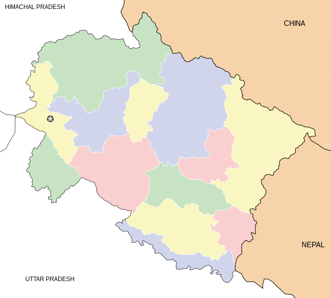
English: Locator map for the state of w:Uttarakhand. Equirectangular projection. Geographic limits of the map: top=31.61, bottom=28.50, left=77.46, right=81.19.
{{Information |Description=Locator map for the state of Uttarakhand updated with white borders for districts |Source=self-made |Date=Feb 2008 |Author= Mkeranat |Permission= |other_versions= }}
{{Information |Title=Uttarakhand locator map |Description=Locator map for the state of [w:Uttarakhand]] |Source=self-made |Date=February 2007 |Author= Mkeranat |Permission= |other_versions= }}
ไฟล, uttarakhand, locator, ไฟล, ประว, ไฟล, หน, าท, ภาพน, การใช, ไฟล, วนกลาง, อม, ลเก, ยวก, บภาพขนาดของต, วอย, าง, ของไฟล, กเซล, ความละเอ, ยดอ, กเซล, กเซล, กเซล, กเซล, กเซล, กเซล, ภาพท, ความละเอ, ยดส, งกว, 8206, ไฟล, กเซล, ขนาดไฟล, โลไบต, ปภาพหร, อไฟล, เส, ยงน,. ifl prawtiifl hnathimiphaphni karichiflswnklang khxmulekiywkbphaphkhnadkhxngtwxyang PNG nikhxngifl SVG ni 666 599 phikesl khwamlaexiydxun 267 240 phikesl 533 480 phikesl 853 768 phikesl 1 138 1 024 phikesl 2 276 2 048 phikesl 1 250 1 125 phikesl duphaphthimikhwamlaexiydsungkwa 8206 ifl SVG 1 250 1 125 phikesl khnadifl 137 kiolibt rupphaphhruxiflesiyngni tnchbbxyuthi khxmmxns raylaexiyddanlang epnkhxkhwamthiaesdngphlcak ifltnchbbinkhxmmxns khxmmxnsepnewbistinokhrngkarsahrbekbrwbrwmsuxesri thi khunsamarthchwyid khwamyx khaxthibayUttarakhand locator map svg English Locator map for the state of w Uttarakhand Equirectangular projection Geographic limits of the map top 31 61 bottom 28 50 left 77 46 right 81 19 wnthi kumphaphnth ph s 2550aehlngthima ngankhxngtwphusrangsrrkh Mkeranat karxnuyatichsiththi khapheca inthanaphuthuxlikhsiththikhxngphaphhruxsuxni xnuyatihichphaphhruxsuxniphayitenguxnikhtxipni xnuyatihkhdlxk aeckcayaela hruxddaeprexksarniphayitenguxnikhkhxngsyyaxnuyatexksaresrikhxngknu run 1 2 hruxrunid nbcaknithixxkodymulnithisxftaewresri odyimmiswnidhamaekikh immikhxkhwampkhnaaelapkhlng saenakhxngsyyaxnuyatrwmxyuinswnchux syyaxnuyatexksaresrikhxngknuhttp www gnu org copyleft fdl html GFDL GNU Free Documentation License true trueiflnixyuphayitsyyaxnuyatkhriexthifkhxmmxns run aesdngthima 3 0 tnchbbkhunsamarth thicaaebngpn thicathasaena aeckcay aelasngngandngklawtxip thicaeriyberiyngihm thicaddaeplngngandngklaw phayitenguxnikhtxipni aesdngthima khuntxngihekiyrtiecakhxngnganxyangehmaasm odyephimlingkipyngsyyaxnuyat aelarabuhakmikarepliynaeplng khunxacthaechnniidinrupaebbidkidtamkhwr aettxngimichinlksnathiaenawaphuihxnuyatsnbsnunkhunhruxkarichngankhxngkhunhttps creativecommons org licenses by 3 0 CC BY 3 0 Creative Commons Attribution 3 0 true truekhunsamartheluxksyyaxnuyatdngklawtamtxngkarkhabrryayodyyxithyephimkhabrryaythrrthdediywephuxkhyaykhwamwaiflnimixairhindiPappu PuriixethmthiaesdngxyuiniflniprakxbdwysthanalikhsiththimilikhsiththisyyaxnuyatGNU Free Documentation License version 1 2 or later xngkvsCreative Commons Attribution 3 0 Unported xngkvsthimakhxngiflkarsrangdngedimodyphuxpohldwnthisrang wnkxtngkumphaphnth 2007 prawtiifl khlikwnthi ewlaephuxduiflthipraktinkhnann wnthi ewlarupyxkhnadphuichkhwamehn pccubn02 48 2 minakhm 25511 250 1 125 137 kiolibt Mkeranat commonswiki Information Description Locator map for the state of Uttarakhand updated with white borders for districts Source self made Date Feb 2008 Author Mkeranat Permission other versions 20 04 10 kumphaphnth 25511 250 1 125 136 kiolibt Mkeranat commonswiki Information Title Uttarakhand locator map Description Locator map for the state of w Uttarakhand Source self made Date February 2007 Author Mkeranat Permission other versions hnathimiphaphni hnatxipni oyngmathiphaphni rthxuttrakhnth karichiflswnklang wikixuntxipniichiflni karichbn ar wikipedia org قالب Location map India Uttarakhand karichbn ast wikipedia org Uttarakhand karichbn as wikipedia org ভ ল অৱ ফ ল ৱ ৰ ছ ৰ ষ ট ৰ য উদ য ন স চ Location map India Uttarakhand উত তৰ খণ ড দ ৰ ড ন karichbn awa wikipedia org ल कसभ च न व क ष त रन कय स च ख च उत तर ख ड कय ल कसभ च न व क ष त र karichbn ba wikipedia org Ҡalyp PozKarta Һindostan Uttarakhand karichbn bh wikipedia org उत तर ख ड karichbn bn wikipedia org উত তর খণ ড ট মপ ল ট অবস থ ন ম নচ ত র ভ রত উত তর খণ ড ন লকন ঠ পর বত প ষ প উপত যক জ ত য উদ য ন ত হর ব ধ আস ন ব য র জ karichbn ceb wikipedia org Plantilya Location map India Uttarakhand karichbn de wikipedia org Wikipedia Kartenwerkstatt Positionskarten Asien karichbn en wikipedia org Template User Uttarakhandi Template User Uttarakhand doc1 Category Uttarakhandi Wikipedians User Hemant Dabral User ह मन त डबर ल User Mrinalbenjwal User JayD99 User Dragon200317 User Sauravtheboy User AS Sayyad User Cartophilic User Prolix sandbox User Yakku3 User मन ष प व र karichbn es wikipedia org Uttarakhand karichbn fa wikipedia org اوتاراکند درادون الگو Location map India Uttarakhand karichbn gu wikipedia org ન ન ત લ ઉત તરક શ ઋષ ક શ મસ ર ર ણ ખ ત karichbn hi wikipedia org हर द व र द हर द न ज ल ॠष क श मस र ब ग श वर प थ र गढ न दप रय ग ज ग श वर ध म अल म ड ज य ल क ट dukarichthwolkephimetimkhxngiflnikhxmulekiywkbphaph phaphnimikhxmulephimetim sungswnihymacakklxngdicitxlhruxsaeknenxrthisamarthekbkhxmuldngklawiwrwmkbphaphid thaphaphnithukprbprungaekikhhruxepliynaeplngcakedim khxmulbangxyangcayngkhngimepliynaeplngehmuxnphaphthithukprbprungaekikhnnkhwamkwang1250khwamsung1125 ekhathungcak https th wikipedia org wiki ifl Uttarakhand locator map svg, wikipedia, วิกิ หนังสือ, หนังสือ, ห้องสมุด,