This map's source is here, with the uploader's modifications, and the GMT homepage says that the tools are released under the GNU General Public License
2006-03-25 03:16 Kelisi 504×540×8 (21 KB) (A map of Victoria Island in the Northwest Territories and Nunavut. This map's source is [http://www.aquarius.geomar.de/omc/make_map.html here], with the uploader's modifications, and the [http://gmt.soest.hawaii.edu/ GMT homepage] says that the tools are )
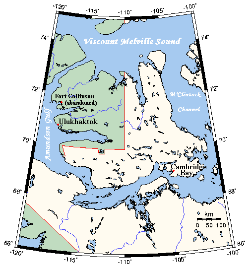
Inhabited hamlets' names have been rendered in bigger type (Fort Collinson has been left smaller), and the local name Ulukhaktok has replaced the former, English name Holman, since the article about the place now has that title.
== Information == {{Information |Description={{en|A map Victoria Island, Canada}} |Source=This map's source is [http://www.aquarius.ifm-geomar.de/ here], with the uploader's modifications, and the [http://gmt.soest.hawaii.edu/ GMT homepage] says that the
ไฟล, victoriaislandmap, ไฟล, ประว, ไฟล, หน, าท, ภาพน, การใช, ไฟล, ามโครงการ, อม, ลเก, ยวก, บภาพไม, ภาพท, รายละเอ, ยดส, งกว, าน, victoriaislandmap, 8206, กเซล, ขนาดไฟล, โลไบต, ชน, ดไมม, image, ปภาพหร, อไฟล, เส, ยงน, นฉบ, บอย, คอมมอนส, รายละเอ, ยดด, านล, าง, เป,. ifl prawtiifl hnathimiphaphni karichiflkhamokhrngkar khxmulekiywkbphaphimmiphaphthimiraylaexiydsungkwani VictoriaIslandMap png 8206 504 540 phikesl khnadifl 27 kiolibt chnidimm image png rupphaphhruxiflesiyngni tnchbbxyuthi khxmmxns raylaexiyddanlang epnkhxkhwamthiaesdngphlcak ifltnchbbinkhxmmxns khxmmxnsepnewbistinokhrngkarsahrbekbrwbrwmsuxesri thi khunsamarthchwyid khwamyx khaxthibayVictoriaIslandMap png English A map Victoria Island Canada wnthi not specified aehlngthima This map s source is here with the uploader s modifications and the GMT homepage says that the tools are released under the GNU General Public License phusrangsrrkh Kelisi at en wikipedia karxnuyatichsiththi Kelisi cakwikiphiediyphasaxngkvs inthanaphuthuxlikhsiththikhxngphaphhruxsuxni xnuyatihichphaphhruxsuxniphayitenguxnikhtxipni iflnixyuphayitsyyaxnuyat khriexthifkhxmmxns aebbaesdngthima xnuyataebbediywkn 3 0 tnchbb thngni epniptamkhxptiesthkhwamrbphidchxb karaesdngthima Kelisi cakwikiphiediyphasaxngkvs khunsamarth thicaaebngpn thicathasaena aeckcay aelasngngandngklawtxip thicaeriyberiyngihm thicaddaeplngngandngklaw phayitenguxnikhtxipni aesdngthima khuntxngihekiyrtiecakhxngnganxyangehmaasm odyephimlingkipyngsyyaxnuyat aelarabuhakmikarepliynaeplng khunxacthaechnniidinrupaebbidkidtamkhwr aettxngimichinlksnathiaenawaphuihxnuyatsnbsnunkhunhruxkarichngankhxngkhun xnuyataebbediywkn hakkhunddaeplng epliynrup hruxtxetimnganni khuntxngichsyyaxnuyataebbediywknhruxaebbthiehmuxnkbsyyaxnuyatthiichkbnganniethann payaesdngsthanalikhsiththinithukephimephuxihepniptamkarepliynaeplngsyyaxnuyatkhxngmulnithiwikimiediy cak GFDL ipyng GFDL khwbkhukb CC BY SA 3 0 http creativecommons org licenses by sa 3 0 CC BY SA 3 0 Creative Commons Attribution Share Alike 3 0 true true xnuyatihkhdlxk aeckcayaela hruxddaeprexksarniphayitenguxnikhkhxngsyyaxnuyatexksaresrikhxngknu run 1 2 hruxrunid nbcaknithixxkodymulnithisxftaewresri odyimmiswnidhamaekikh immikhxkhwampkhnaaelapkhlng saenakhxngsyyaxnuyatrwmxyuinswnchux syyaxnuyatexksaresrikhxngknu thngni epniptamkhxptiesthkhwamrbphidchxbhttp www gnu org copyleft fdl html GFDL GNU Free Documentation License true true bnthukkarxphohld All following user names refer to en wikipedia 2006 03 25 03 16 Kelisi 504 540 8 21 KB A map of Victoria Island in the Northwest Territories and Nunavut This map s source is http www aquarius geomar de omc make map html here with the uploader s modifications and the http gmt soest hawaii edu GMT homepage says that the tools are khabrryayodyyxithyephimkhabrryaythrrthdediywephuxkhyaykhwamwaiflnimixairixethmthiaesdngxyuiniflniprakxbdwysthanalikhsiththimilikhsiththisyyaxnuyatGNU Free Documentation License version 1 2 or later nbsp xngkvsCreative Commons Attribution ShareAlike 3 0 Unported nbsp xngkvsphasakhxngnganhruxchuxphasaxngkvsmedia type nbsp xngkvsimage png prawtiifl khlikwnthi ewlaephuxduiflthipraktinkhnann wnthi ewlarupyxkhnadphuichkhwamehn pccubn08 53 31 mkrakhm 2564504 540 27 kiolibt KelisiOops That was silly Sorry I 039 ll try again 08 50 31 mkrakhm 2564504 540 27 kiolibt KelisiInhabited hamlets 039 names have been rendered in bigger type Fort Collinson has been left smaller and the local name Ulukhaktok has replaced the former English name Holman since the article about the place now has that title 18 32 13 singhakhm 2551504 540 21 kiolibt Telim tor Information Information Description en A map Victoria Island Canada Source This map 039 s source is http www aquarius ifm geomar de here with the uploader 039 s modifications and the http gmt soest hawaii edu GMT homepage says that the hnathimiphaphni hnatxipni oyngmathiphaphni esnkhnanthi 70 xngsaehnux karichiflkhamokhrngkar wikixuntxipniichiflni karichbn af wikipedia org Victoria eiland karichbn bg wikipedia org Dzheni Lind ostrov Melbrn ostrov karichbn bs wikipedia org 70 paralela sjever karichbn ca wikipedia org Illa Victoria Paral lel 70 nord karichbn ckb wikipedia org نوونڤووت karichbn da wikipedia org Kitlineq karichbn en wikipedia org Victoria Island 70th parallel north Prince Albert Peninsula karichbn eo wikipedia org Nunavuto karichbn es wikipedia org Isla Victoria Canada karichbn fa wikipedia org نوناووت karichbn gl wikipedia org Illa Victoria karichbn hu wikipedia org Victoria sziget Kanada karichbn ilo wikipedia org Maika 70 a paralelo amianan karichbn nn wikipedia org Kitlineq karichbn no wikipedia org Fort Collinson karichbn pl wikipedia org Wyspa Wiktorii karichbn ro wikipedia org Insula Victoria karichbn tt wikipedia org Viktoriya utrau Kanada karichbn www wikidata org Q5470966 karichbn zh wikipedia org 北纬70度线khxmulekiywkbphaph phaphnimikhxmulephimetim sungswnihymacakklxngdicitxlhruxsaeknenxrthisamarthekbkhxmuldngklawiwrwmkbphaphid thaphaphnithukprbprungaekikhhruxepliynaeplngcakedim khxmulbangxyangcayngkhngimepliynaeplngehmuxnphaphthithukprbprungaekikhnnkhwamlaexiydaenwnxn37 8 dpckhwamlaexiydaenwtng37 8 dpc ekhathungcak https th wikipedia org wiki ifl VictoriaIslandMap png, wikipedia, วิกิ หนังสือ, หนังสือ, ห้องสมุด,