Peel, M. C. and Finlayson, B. L. and McMahon, T. A. (2007). "Updated world map of the Köppen-Geiger climate classification". Hydrol. Earth Syst. Sci.11: 1633-1644. ISSN 1027-5606.
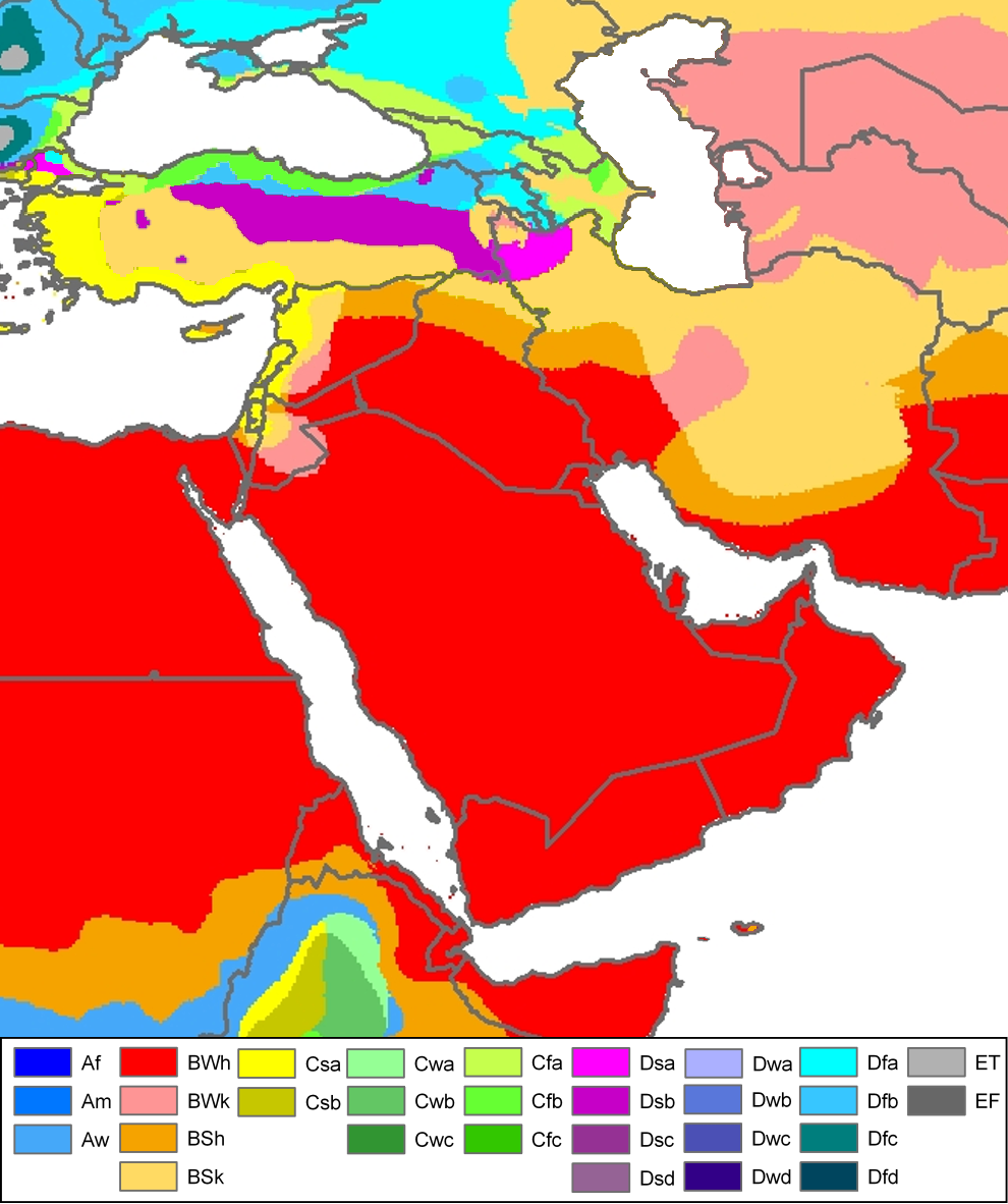
Climate map of (South)west-Asia and adjacent areas (from the "Updated world map of the Köppen-Geiger climate classification").
วันที่
แหล่งที่มา
Hydrology and Earth System Sciences: "Updated world map of the Köppen-Geiger climate classification" (Supplement) - Original file was a JPG-file, this file is has been converted to a PNG-file, without extra modifications, by me (Jeroen).
ผู้สร้างสรรค์
Peel, M. C., Finlayson, B. L., and McMahon, T. A. (University of Melbourne)
Painted the Caspian Sea as white as it should have been, because the Köppen system is based on the concept that climate types are correlated with the natural vegetation. Thus with Köppen, climate zone boundaries have been selected with vegetation distri
Citation: '''Peel, M. C., Finlayson, B. L., and McMahon, T. A.: Updated world map of the Köppen-Geiger climate classification, Hydrol. Earth Syst. Sci., 11, 1633-1644, 2007.''' {{Information |Description= Climate map of North-America (from the "[[:Ima
ไฟล, west, asia, köppen, ไฟล, ประว, ไฟล, หน, าท, ภาพน, การใช, ไฟล, วนกลาง, อม, ลเก, ยวก, บภาพขนาดของต, วอย, างน, กเซล, ความละเอ, ยดอ, กเซล, กเซล, กเซล, ภาพท, ความละเอ, ยดส, งกว, 8206, กเซล, ขนาดไฟล, โลไบต, ชน, ดไมม, image, ปภาพหร, อไฟล, เส, ยงน, นฉบ, บอย, คอมม. ifl prawtiifl hnathimiphaphni karichiflswnklang khxmulekiywkbphaphkhnadkhxngtwxyangni 502 599 phikesl khwamlaexiydxun 201 240 phikesl 402 480 phikesl 990 1 182 phikesl duphaphthimikhwamlaexiydsungkwa 8206 990 1 182 phikesl khnadifl 511 kiolibt chnidimm image png rupphaphhruxiflesiyngni tnchbbxyuthi khxmmxns raylaexiyddanlang epnkhxkhwamthiaesdngphlcak ifltnchbbinkhxmmxns khxmmxnsepnewbistinokhrngkarsahrbekbrwbrwmsuxesri thi khunsamarthchwyid Peel M C and Finlayson B L and McMahon T A 2007 Updated world map of the Koppen Geiger climate classification Hydrol Earth Syst Sci 11 1633 1644 ISSN 1027 5606 enuxha 1 Legend 2 khwamyx 3 Related maps 4 karxnuyatichsiththiLegend Af equatorial climate Am monsoon climate Aw tropical savanna climate BWh warm desert climate BWk cold desert climate BSh warm semi arid climate BSk cold semi arid climate Csa warm mediterranean climate Csb temperate mediterranean climate Cwa humid subtropical climate Cwb humid subtropical climate subtropical oceanic highland climate Cwc oceanic subpolar climate Cfa warm oceanic climate humid subtropical climate Cfb temperate oceanic climate Cfc cool oceanic climate Dsa warm continental climate mediterranean continental climate Dsb temperate continental climate mediterranean continental climate Dsc cool continental climate Dsd cold continental climate Dwa warm continental climate humid continental climate Dwb temperate continental climate humid continental climate Dwc cool continental climate subarctic climate Dwd cold continental climate subarctic climate Dfa warm continental climate humid continental climate Dfb temperate continental climate humid continental climate Dfc cool continental climate subarctic climate Dfd cold continental climate subarctic climate ET tundra climate EF ice cap climateEnglish khwamyx khaxthibayWest Asia Koppen Map png Climate map of South west Asia and adjacent areas from the Updated world map of the Koppen Geiger climate classification wnthi 12 tulakhm ph s 2550aehlngthima Hydrology and Earth System Sciences Updated world map of the Koppen Geiger climate classification Supplement Original file was a JPG file this file is has been converted to a PNG file without extra modifications by me Jeroen phusrangsrrkh Peel M C Finlayson B L and McMahon T A University of Melbourne karxnuyat karichiflniihm khxkhwamxnuyatcakecakhxnglikhsiththiihichnganphaphhruxsuxni idrbkartrwcsxbaelw aelathukekbiwinxasasmkhrtxbklbxieml VRT odysahrbphuichthimibychi VRT samarthtrwcsxbbnthukekiywkbkhxkhwamxnuyatnnid inbnthukhmayelkh 2011040110025998 hakthantxngkarnaphaphhruxsuxniipichthixunnxkehnuxcakinmulnithiwikimiediy krunaxankhxmulekiywkbkarnaenuxhaipichnxkmulnithiwikimiediythihnani thngnihakthanprasngkhcakhxkhayunynekiywkbkarxnuyatihichichphaphhruxsuxni krunatidtxphuichthimibychi VRT hruxaecngphanhnaaecng VRT lingkkhxngbnthuk https ticket wikimedia org otrs index pl Action AgentTicketZoom amp TicketNumber 2011040110025998 Find other files from the same ticket phaph meteorology ni khwrcathuksrangihmepnkrafiksewketxr sungmikhxdixikhlayprakar duephimetimthikhxmmxns suxtxngkarekbkwadsahrbsarsnethsephimetim hakphaphnimiinrupaebbkrafiksewketxrxyuaelw krunaxpohldaelaaethnthiaemaebbnidwy vector version available i chuxphaphihm i aenanaepnxyangyingihtngchuxiflewketxrihmnninrupaebb West Asia Koppen Map svg aelwisaemaebb Vector version available hrux Vva sungimtxngichpharamietxr chuxphaphihmRelated maps User Jeroenvrp made for these continents and areas a cropped and resized version Africa Koppen Map png Asia Koppen Map png Australia Oceania Koppen Map png Europe Koppen Map png North America Koppen Map png Russia Koppen Map png South America Koppen Map png West Asia Koppen Map png User LordToran made from the same data these maps Klimagurtel der erde eisklima png Klimagurtel der erde gemassigte zone png Klimagurtel der erde polargebiete png Klimagurtel der erde subtropen png Klimagurtel der erde tropen png Klimagurtel der erde tundra png Klimagurtel der erde warmgemassigte zone png Klimagurtel der erde png Klimagurtel der erde svg Klimate humiditat png Koppen geiger hessd 2007 svg Koppen vereinfacht svg Trockenklimate pngkarxnuyatichsiththi iflnixyuphayitsyyaxnuyat khriexthifkhxmmxns aebbaesdngthima xnuyataebbediywkn 3 0 tnchbbkhunsamarth thicaaebngpn thicathasaena aeckcay aelasngngandngklawtxip thicaeriyberiyngihm thicaddaeplngngandngklaw phayitenguxnikhtxipni aesdngthima khuntxngihekiyrtiecakhxngnganxyangehmaasm odyephimlingkipyngsyyaxnuyat aelarabuhakmikarepliynaeplng khunxacthaechnniidinrupaebbidkidtamkhwr aettxngimichinlksnathiaenawaphuihxnuyatsnbsnunkhunhruxkarichngankhxngkhun xnuyataebbediywkn hakkhunddaeplng epliynrup hruxtxetimnganni khuntxngichsyyaxnuyataebbediywknhruxaebbthiehmuxnkbsyyaxnuyatthiichkbnganniethannhttps creativecommons org licenses by sa 3 0 CC BY SA 3 0 Creative Commons Attribution Share Alike 3 0 true truekhabrryayodyyxithyephimkhabrryaythrrthdediywephuxkhyaykhwamwaiflnimixairyipunケッペンの気候区分 中東ixethmthiaesdngxyuiniflniprakxbdwysthanalikhsiththimilikhsiththisyyaxnuyatCreative Commons Attribution ShareAlike 3 0 Unported xngkvsWikimedia VRTS ticket number xngkvs2011040110025998wnthisrang wnkxtng12 tulakhm 2007 prawtiifl khlikwnthi ewlaephuxduiflthipraktinkhnann wnthi ewlarupyxkhnadphuichkhwamehn pccubn19 57 21 phvscikayn 2559990 1 182 511 kiolibt Pandakekok9Transparent 19 23 13 minakhm 2554990 1 182 543 kiolibt MaphobbyistPainted the Caspian Sea as white as it should have been because the Koppen system is based on the concept that climate types are correlated with the natural vegetation Thus with Koppen climate zone boundaries have been selected with vegetation distri 06 01 13 tulakhm 2550990 1 182 507 kiolibt JeroenCitation 039 039 039 Peel M C Finlayson B L and McMahon T A Updated world map of the Koppen Geiger climate classification Hydrol Earth Syst Sci 11 1633 1644 2007 039 039 039 Information Description Climate map of North America from the Ima hnathimiphaphni hnatxipni oyngmathiphaphni karaebngekhtphumixakasaebbekhiphephin karichiflswnklang wikixuntxipniichiflni karichbn af wikipedia org Saoedi Arabie karichbn ar wikipedia org غرب آسيا karichbn de wikipedia org Kaukasus karichbn en wikipedia org Western Asia User 2know4power sandbox Wikipedia Reference desk Archives Humanities 2019 July 29 karichbn eo wikipedia org Klimato Klimata klasifiko de Koppen karichbn es wikipedia org Geografia de Arabia Saudita karichbn es wikibooks org Wikichicos La Tierra Los continentes Asia Clima Wikichicos La Tierra Texto completo karichbn eu wikipedia org Saudi Arabia karichbn fy wikipedia org Klimaatklassifikaasje fan Koppen karichbn ha wikipedia org Yammacin Asiya karichbn hy wikipedia org Սաուդյան Արաբիա karichbn it wikipedia org Asia occidentale karichbn ja wikipedia org ケッペンの気候区分 karichbn ja wikibooks org 高等学校地理探究 西アジアと中央アジア karichbn nl wikipedia org Zuidwest Azie Oude Nabije Oosten karichbn nn wikipedia org Saudi Arabia Saudiarabisk geografi karichbn oc wikipedia org Asia Occidentala karichbn ro wikipedia org Asia de Vest karichbn sl wikipedia org Koppnova podnebna klasifikacija karichbn sr wikipedia org Saudiјska Arabiјa karichbn te wikipedia org స ద అర బ య karichbn uk wikipedia org Geografiya Saudivskoyi Araviyi karichbn vi wikipedia org Tay Akhxmulekiywkbphaph phaphnimikhxmulephimetim sungswnihymacakklxngdicitxlhruxsaeknenxrthisamarthekbkhxmuldngklawiwrwmkbphaphid thaphaphnithukprbprungaekikhhruxepliynaeplngcakedim khxmulbangxyangcayngkhngimepliynaeplngehmuxnphaphthithukprbprungaekikhnnkhwamlaexiydaenwnxn37 8 dpckhwamlaexiydaenwtng37 8 dpc ekhathungcak https th wikipedia org wiki ifl West Asia Koppen Map png, wikipedia, วิกิ หนังสือ, หนังสือ, ห้องสมุด,