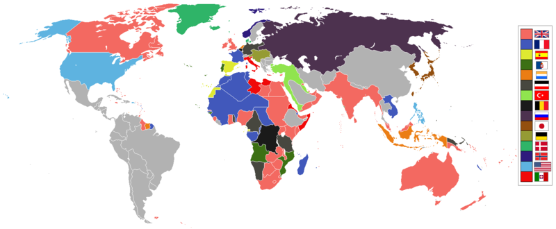
If an old map with wrongly drawn borders is replaced with a better map wth a minor colour error, then fix that minor colour error. Don't just blithely revert to the bad old map.
Removed borders between provinces of Australia, as requested at https://en.wikipedia.org/wiki/Wikipedia:Graphics_Lab/Map_workshop#FIFA_World_Cup_Maps_-_Colonial_Boundaries , because it had been united into a single dominion before 1914.
ไฟล, world, 1914, empires, colonies, territory, ไฟล, ประว, ไฟล, หน, าท, ภาพน, การใช, ไฟล, วนกลาง, อม, ลเก, ยวก, บภาพขนาดของต, วอย, างน, กเซล, ความละเอ, ยดอ, กเซล, กเซล, กเซล, ภาพท, ความละเอ, ยดส, งกว, 8206, กเซล, ขนาดไฟล, โลไบต, ชน, ดไมม, image, ปภาพหร, อไฟล, . ifl prawtiifl hnathimiphaphni karichiflswnklang khxmulekiywkbphaphkhnadkhxngtwxyangni 800 330 phikesl khwamlaexiydxun 320 132 phikesl 640 264 phikesl 1 522 628 phikesl duphaphthimikhwamlaexiydsungkwa 8206 1 522 628 phikesl khnadifl 45 kiolibt chnidimm image png rupphaphhruxiflesiyngni tnchbbxyuthi khxmmxns raylaexiyddanlang epnkhxkhwamthiaesdngphlcak ifltnchbbinkhxmmxns khxmmxnsepnewbistinokhrngkarsahrbekbrwbrwmsuxesri thi khunsamarthchwyid phaphaephnthini khwrcathuksrangihmepnkrafiksewketxr sungmikhxdixikhlayprakar duephimetimthikhxmmxns suxtxngkarekbkwadsahrbsarsnethsephimetim hakphaphnimiinrupaebbkrafiksewketxrxyuaelw krunaxpohldaelaaethnthiaemaebbnidwy vector version available i chuxphaphihm i aenanaepnxyangyingihtngchuxiflewketxrihmnninrupaebb World 1914 empires colonies territory svg aelwisaemaebb Vector version available hrux Vva sungimtxngichpharamietxr chuxphaphihmkhwamyx khaxthibayWorld 1914 empires colonies territory PNG English World empires and colonies in 1914 just before the First World War Maps of world historyBC 2000 1000 500 400 323 300 200 100 50AD 1 50 100 200 250 300 400 500 700 750 820 900 1556 1700 1815 1859Maps of colonization history1492 1550 1600 1660 1754 1800 1812 1822 1885 1898 1914 1920 1936 1938 1945 1959 1974 1975 2007Animated MapMaps of Cold War1959 1980 Nows see also Eastern Hemisphere only maps template 1300BC 1500AD this template view discuss wnthi 27 krkdakhm ph s 2553aehlngthima ngankhxngtwphusrangsrrkh Andrew0921 British Empire France Spain Portugal Netherlands German Empire Ottoman Belgium Russia Japan Austria Hungary Denmark Norway United States of America Italy Independent other countries karxnuyatichsiththi khapheca inthanaphuthuxlikhsiththikhxngphaphhruxsuxni xnuyatihichphaphhruxsuxniphayitenguxnikhtxipniiflnixyuphayitsyyaxnuyatkhriexthifkhxmmxns run aesdngthima 3 0 tnchbbkhunsamarth thicaaebngpn thicathasaena aeckcay aelasngngandngklawtxip thicaeriyberiyngihm thicaddaeplngngandngklaw phayitenguxnikhtxipni aesdngthima khuntxngihekiyrtiecakhxngnganxyangehmaasm odyephimlingkipyngsyyaxnuyat aelarabuhakmikarepliynaeplng khunxacthaechnniidinrupaebbidkidtamkhwr aettxngimichinlksnathiaenawaphuihxnuyatsnbsnunkhunhruxkarichngankhxngkhunhttps creativecommons org licenses by 3 0 CC BY 3 0 Creative Commons Attribution 3 0 true truekhabrryayodyyxithyephimkhabrryaythrrthdediywephuxkhyaykhwamwaiflnimixairepxresiyامپراتوری ها و مستعمرات جهانی در سال ۱۹۱۴ درست قبل از جنگ جهانی اول ixethmthiaesdngxyuiniflniprakxbdwyaephnthiolkphaphprakxbphusrangbangkhathiimmiixethmwikisnethschuxphusrangsrrkh Andrew0921yuxaraexl https commons wikimedia org wiki user Andrew0921chuxphuichwikimiediy Andrew0921sthanalikhsiththimilikhsiththisyyaxnuyatCreative Commons Attribution 3 0 Unported xngkvsthimakhxngiflkarsrangdngedimodyphuxpohldwnthisrang wnkxtng27 krkdakhm 2010MIME type xngkvsimage png prawtiifl khlikwnthi ewlaephuxduiflthipraktinkhnann lasud ekasud du ihmkwa 10 ekakwa 10 10 20 50 100 250 500 wnthi ewlarupyxkhnadphuichkhwamehn pccubn16 28 8 phvscikayn 25641 522 628 45 kiolibt Randomastwritterjubaland 07 00 14 emsayn 25641 522 628 45 kiolibt Offa29Fixed Togoland colour 01 57 25 emsayn 25631 522 628 45 kiolibt The Norwegian flag 00 08 25 emsayn 25631 522 628 45 kiolibt The If an old map with wrongly drawn borders is replaced with a better map wth a minor colour error then fix that minor colour error Don 039 t just blithely revert to the bad old map 04 52 18 minakhm 25631 474 620 36 kiolibt MakkkkusReplaced the Swedish Norwegian union flag with the Norwegian flag 02 25 14 minakhm 25631 474 620 22 kiolibt Morris frankThe new version introduced a big regression coloring spain in the color of italy also it did not contribute anything useful 04 49 15 singhakhm 25621 522 628 45 kiolibt The More accurate map 19 47 5 krkdakhm 25591 474 620 22 kiolibt MaproomRemoved borders between provinces of Australia as requested at https en wikipedia org wiki Wikipedia Graphics Lab Map workshop FIFA World Cup Maps Colonial Boundaries because it had been united into a single dominion before 1914 07 00 26 thnwakhm 25531 474 620 33 kiolibt Quigleyby 1914 Qing Dynasty had collapsed and Republic of China established 20 56 22 phvscikayn 25531 474 620 20 kiolibt AnonMooscropping margins increasing PNG compression lasud ekasud du ihmkwa 10 ekakwa 10 10 20 50 100 250 500 hnathimiphaphni hnatxipni oyngmathiphaphni lththixananikhm sngkhramolkkhrngthihnung karichiflswnklang wikixuntxipniichiflni karichbn af wikipedia org Eerste Wereldoorlog Kolonialisme karichbn ar wikipedia org استعمارية karichbn azb wikipedia org ۲۰ یوز ایل karichbn bn wikipedia org উপন ব শব দ karichbn ca wikipedia org Colonialisme karichbn da wikipedia org Kolonialisme karichbn en wikipedia org Colonialism Woodrow Wilson 20th century Muslim world Allies of World War I World War I Presidency of Woodrow Wilson User Gōd cyning Wikipedia Graphics Lab Map workshop Archive 2016 Portal Modern history History of U S foreign policy 1913 1933 User Falcaorib User Kuba2084Qsfgk sandbox karichbn eo wikipedia org 20 a jarcento Koloniismo karichbn eo wikiquote org 20 a jarcento karichbn es wikipedia org Expansion europea karichbn fa wikipedia org استعمار karichbn fi wikipedia org Imperialismi karichbn fr wikipedia org Presidence de Woodrow Wilson karichbn fy wikipedia org Kolonialisme karichbn gl wikipedia org Imperialismo karichbn hu wikipedia org Egykori gyarmatok es fuggo teruletek listaja karichbn it wikipedia org Presidenza di Woodrow Wilson karichbn ja wikipedia org 植民地 外交 植民地主義 貿易史 karichbn jv wikipedia org Abad ping 20 ꦲꦧꦢ ꦥ ꧒꧐ karichbn ka wikipedia org კოლონიალიზმი karichbn lv wikipedia org Lielvalsts karichbn mk wikipedia org 20 vek karichbn ml wikipedia org ക ളന വ ഴ ച karichbn oc wikipedia org Wikipedia AcuelhLutzSus marc de 2013 Wikipedia AcuelhLutzSus 14 de marc de 2013 karichbn pt wikipedia org Colonialismo Usuario a Historiadordomundo esboco karichbn te wikipedia org మ దట ప రప చ య ద ధ 20 వ శత బ ద karichbn www wikidata org Q7167 karichbn xmf wikipedia org კოლონიალიზმი karichbn zh wikipedia org 殖民主义khxmulekiywkbphaph phaphnimikhxmulephimetim sungswnihymacakklxngdicitxlhruxsaeknenxrthisamarthekbkhxmuldngklawiwrwmkbphaphid thaphaphnithukprbprungaekikhhruxepliynaeplngcakedim khxmulbangxyangcayngkhngimepliynaeplngehmuxnphaphthithukprbprungaekikhnnkhwamlaexiydaenwnxn47 24 dpckhwamlaexiydaenwtng47 24 dpc ekhathungcak https th wikipedia org wiki ifl World 1914 empires colonies territory PNG, wikipedia, วิกิ หนังสือ, หนังสือ, ห้องสมุด,