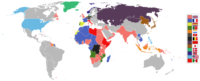
The Dominions should not be shaded in British Empire colour post-1931 Statute of Westmisnter. They had independent foreign policies and were no longer under British control in any way, shape or form.
ไฟล, world, 1936, empires, colonies, territory, ไฟล, ประว, ไฟล, หน, าท, ภาพน, การใช, ไฟล, วนกลาง, อม, ลเก, ยวก, บภาพขนาดของต, วอย, างน, กเซล, ความละเอ, ยดอ, กเซล, กเซล, กเซล, ภาพท, ความละเอ, ยดส, งกว, 8206, กเซล, ขนาดไฟล, โลไบต, ชน, ดไมม, image, ปภาพหร, อไฟล, . ifl prawtiifl hnathimiphaphni karichiflswnklang khxmulekiywkbphaphkhnadkhxngtwxyangni 800 327 phikesl khwamlaexiydxun 320 131 phikesl 640 262 phikesl 1 527 624 phikesl duphaphthimikhwamlaexiydsungkwa 8206 1 527 624 phikesl khnadifl 44 kiolibt chnidimm image png rupphaphhruxiflesiyngni tnchbbxyuthi khxmmxns raylaexiyddanlang epnkhxkhwamthiaesdngphlcak ifltnchbbinkhxmmxns khxmmxnsepnewbistinokhrngkarsahrbekbrwbrwmsuxesri thi khunsamarthchwyid 1936 coolio stuff enuxha 1 khwamyx 1 1 العربية 1 2 English 1 3 മലയ ള 1 4 Deutsch 1 5 한국어 1 6 Ukrayinska 1 7 简体中文 1 8 繁體中文 2 See also 3 karxnuyatichsiththi khwamyx العربية القوى والمستعمرات العالمية قبل الحرب العالمية الثانية English world empires and colonies 1936 before the Second World War derived from Image BlankMap World WWII PNG 中文 中国大陆 1936年 第二次世界大战前夕 世界各帝国及其殖民地与附属领土一览图 中文 臺灣 第二次世界大戰前夕1936年世界上的帝國和殖民地 العربية المملكة المتحدة فرنسا إسبانيا البرتغال هولندا ألمانيا النازية بلجيكا الاتحاد السوفيتي اليابان الدنمارك النرويج الولايات المتحدة إيطاليا البلدان المستقلة غير ذلك English UK and Commonwealth France Spain Portugal Netherlands Germany Belgium USSR Japan Denmark Norway USA Italy Independent other countries മലയ ള യ ക ക മൺവ ൽത ത ഫ ര ൻസ സ പ യ ൻ പ ർച ച ഗൽ ന തർല ൻഡ സ ന സ ജർമ മന ബ ൽജ യ സ വ യറ റ ജപ പ ൻ ഡ ന മ ർക ക ന ർവ യ എസ എ ഇറ റല സ വതന ത ര മറ റ ര ജ യങ ങൾ Deutsch Grossbritannien Frankreich Spanien USSR Japan USA Italien Unabhangig andere Lander 한국어 영국 프랑스 스페인 포르투갈 네덜란드 독일 벨기에 소련 일본 덴마크 노르웨이 미국 이탈리아 독립국 기타 Ukrayinska Velikobritaniya Franciya Ispaniya Portugaliya Niderlandi Belgiya SRSR Yaponiya Daniya Norvegiya SShA Italiya Nezalezhni derzhavi koloniyi inshih krayin 简体中文 大不列颠及北爱尔兰联合王国 联合王国 英国 法兰西 第三 共和国 法国 西班牙 第二 共和国 西班牙 葡萄牙 第二 共和国 葡萄牙 荷兰王国 荷兰 德意志 第三 帝国 德国 比利时王国 比利时 苏维埃社会主义共和国联盟 苏联 大日本帝国 日本 丹麦王国 丹麦 挪威王国 挪威 美利坚合众国 美国 意大利王国 意大利 其余独立国家与地区 繁體中文 英國 法國 西班牙 葡萄牙 荷蘭 德國 比利時 蘇聯 日本 丹麥 挪威 美國 義大利 其他國家 獨立 phaphaephnthithangprawtisastrni khwrcathuksrangihmepnkrafiksewketxr sungmikhxdixikhlayprakar duephimetimthikhxmmxns suxtxngkarekbkwadsahrbsarsnethsephimetim hakphaphnimiinrupaebbkrafiksewketxrxyuaelw krunaxpohldaelaaethnthiaemaebbnidwy vector version available i chuxphaphihm i aenanaepnxyangyingihtngchuxiflewketxrihmnninrupaebb World 1936 empires colonies territory svg aelwisaemaebb Vector version available hrux Vva sungimtxngichpharamietxr chuxphaphihmkhaptiesthkhwamrbphidaelakhxkhwrrawngekiywkbkdhmay phaphniaesdngekhruxnghmaykhxnglththikhxmmiwnistsungepnsingphidkdhmayinpraethstxipni idaek hngkari tampramwlkdhmayxayahngkarimatra 269 thwi kh s 1993 ltewiy lithweniy aelaopaelnd thngnikhunxyukbectnakarichphaphnikhaptiesthkhwamrbphid aelakhxkhwrrawngekiywkbkdhmay phaphniepnphaphekhruxnghmaythangkar hruxepnphaphthikhlaykbekhruxnghmaythangkar khxngrthbalsngkhmniymaehngchatieyxrmni nasi hruxxngkhkrthiekiywkhxngxun echn ekhruxnghmayswstika hruxekhruxnghmaykangekhnsr sungsalrththrrmnuyaehngshphnthsatharnrtheyxrmni idprakaskhaphiphaksaihpranamtrani inthanasuxaehngkhwamrunaerngaelakhwamirmnusythrrmkhxngxdxlf hitelxr phrxmphwk thungaemwakarichaela hruxaesdngekhruxnghmaydngklaw caepnkarkrathathikhdtxbthbyytiaehngkdhmayinhlaypraeths idaek eyxrmni xxsetriy hngkari opaelnd echkekiy frngess brasil aelapraethsxun thimibthbyytipxngpramkaraesdngekhruxnghmaythangkarkhxngrthbalsngkhmniymaehngchatieyxrmni aelamiidklawthungiwinthini aetwtthuprasngkhkhxngkarxpohldphaphinwikimiediykhxmmxnsni ephuxichpraoychnthangkarsuksaaelaihkhxmulepnsakhy miidmiectnaplukpnihekidkhwamaetkaeykinchatiphuidrbkhwamesiyhaycakrthbalsngkhmniymaehngchatieyxrmniSee also 1920 1936 1945 and 1975Maps of world historyBC 2000 1000 500 400 323 300 200 100 50AD 1 50 100 200 250 300 400 500 700 750 820 900 1556 1700 1815 1859Maps of colonization history1492 1550 1600 1660 1754 1800 1812 1822 1885 1898 1914 1920 1936 1938 1945 1959 1974 1975 2007Animated MapMaps of Cold War1959 1980 Nows see also Eastern Hemisphere only maps template 1300BC 1500AD this template view discuss karxnuyatichsiththi khapheca inthanaphuthuxlikhsiththikhxngphaphhruxsuxni xnuyatihichphaphhruxsuxniphayitenguxnikhtxipni xnuyatihkhdlxk aeckcayaela hruxddaeprexksarniphayitenguxnikhkhxngsyyaxnuyatexksaresrikhxngknu run 1 2 hruxrunid nbcaknithixxkodymulnithisxftaewresri odyimmiswnidhamaekikh immikhxkhwampkhnaaelapkhlng saenakhxngsyyaxnuyatrwmxyuinswnchux syyaxnuyatexksaresrikhxngknuhttp www gnu org copyleft fdl html GFDL GNU Free Documentation License true trueiflnixyuphayitsyyaxnuyat khriexthifkhxmmxns aebbaesdngthima xnuyataebbediywkn 3 0 tnchbbkhunsamarth thicaaebngpn thicathasaena aeckcay aelasngngandngklawtxip thicaeriyberiyngihm thicaddaeplngngandngklaw phayitenguxnikhtxipni aesdngthima khuntxngihekiyrtiecakhxngnganxyangehmaasm odyephimlingkipyngsyyaxnuyat aelarabuhakmikarepliynaeplng khunxacthaechnniidinrupaebbidkidtamkhwr aettxngimichinlksnathiaenawaphuihxnuyatsnbsnunkhunhruxkarichngankhxngkhun xnuyataebbediywkn hakkhunddaeplng epliynrup hruxtxetimnganni khuntxngichsyyaxnuyataebbediywknhruxaebbthiehmuxnkbsyyaxnuyatthiichkbnganniethannpayaesdngsthanalikhsiththinithukephimephuxihepniptamkarepliynaeplngsyyaxnuyatkhxngmulnithiwikimiediy cak GFDL ipyng GFDL khwbkhukb CC BY SA 3 0 http creativecommons org licenses by sa 3 0 CC BY SA 3 0 Creative Commons Attribution Share Alike 3 0 true truekhabrryayodyyxithyephimkhabrryaythrrthdediywephuxkhyaykhwamwaiflnimixairixethmthiaesdngxyuiniflniprakxbdwyaephnthisthanalikhsiththimilikhsiththisyyaxnuyatGNU Free Documentation License version 1 2 or later xngkvsCreative Commons Attribution ShareAlike 3 0 Unported xngkvsMIME type xngkvsimage png prawtiifl khlikwnthi ewlaephuxduiflthipraktinkhnann lasud ekasud du ihmkwa 10 ekakwa 10 10 20 50 100 250 500 wnthi ewlarupyxkhnadphuichkhwamehn pccubn20 41 6 phvsphakhm 25631 527 624 44 kiolibt The The Dominions should not be shaded in British Empire colour post 1931 Statute of Westmisnter They had independent foreign policies and were no longer under British control in any way shape or form 19 34 12 phvsphakhm 25621 527 624 44 kiolibt The If there are some problems with the accurate map fix the accurate map don 039 t revert back to the old inaccurate map 14 34 12 knyayn 25611 458 627 33 kiolibt Oleksiy golubovReverted to version as of 13 34 29 July 2012 UTC no reason to indicate Turkey and China colors of Belgium and the Netherlands were wrong 02 51 21 krkdakhm 25611 527 624 3 64 emkaibt SuperSuckeroops forgot Germany had Nazi flag in 1936 02 39 21 krkdakhm 25611 527 624 3 64 emkaibt SuperSuckerfix added Turkey it existed as Turkey in 1936 and China changed China 039 s flag as they had it changed by 1930 21 47 20 singhakhm 25591 527 624 44 kiolibt The Some fixes 03 29 18 emsayn 25591 527 624 44 kiolibt The More accurate map 20 34 29 krkdakhm 25551 458 627 33 kiolibt FaunasReverted to version as of 13 31 29 July 2012 20 33 29 krkdakhm 25551 458 627 33 kiolibt FaunasIn the previous version Sao Tome e Principe was indicated as a Spanish colony I changed it to indicate it was a Portuguese colony which it was 20 31 29 krkdakhm 25551 458 627 33 kiolibt FaunasIn the previous version Sao Tome e Principe was indicated as a Spanish colony I changed it to indicate it was a Portuguese colony which it was lasud ekasud du ihmkwa 10 ekakwa 10 10 20 50 100 250 500 hnathimiphaphni hnatxipni oyngmathiphaphni lththixananikhm karichiflswnklang wikixuntxipniichiflni karichbn af wikipedia org Tweede Wereldoorlog karichbn am wikipedia org 1928 karichbn ar wikipedia org استعمارية karichbn arz wikipedia org استعمار karichbn az wikipedia org Imperiya karichbn bn wikipedia org উপন ব শব দ উপন ব শ স থ পন karichbn de wikipedia org Zwischenkriegszeit Benutzer Casadopovo EURAFRICA karichbn en wikipedia org Colonialism Colonization User Falcaorib karichbn fa wikipedia org استعمار karichbn fr wikipedia org Decolonisation karichbn ja wikipedia org Portal 大東亜共栄圏 Portal 大東亜共栄圏 世界 karichbn li wikipedia org Kolonisatie karichbn mg wikipedia org Fanjanahantany karichbn ms wikipedia org Empayar karichbn nl wikipedia org Kolonisatie karichbn pt wikipedia org Periodo entreguerras karichbn sr wikipedia org Drugi svetski rat karichbn uk wikipedia org Druga svitova vijna karichbn www wikidata org Q7167khxmulekiywkbphaph phaphnimikhxmulephimetim sungswnihymacakklxngdicitxlhruxsaeknenxrthisamarthekbkhxmuldngklawiwrwmkbphaphid thaphaphnithukprbprungaekikhhruxepliynaeplngcakedim khxmulbangxyangcayngkhngimepliynaeplngehmuxnphaphthithukprbprungaekikhnnkhwamlaexiydaenwnxn37 8 dpckhwamlaexiydaenwtng37 8 dpc ekhathungcak https th wikipedia org wiki ifl World 1936 empires colonies territory png, wikipedia, วิกิ หนังสือ, หนังสือ, ห้องสมุด,