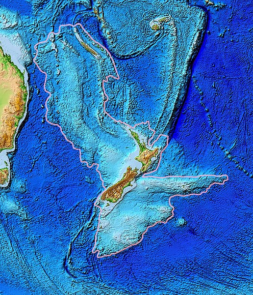
ไฟล, zealandia, topography, ไฟล, ประว, ไฟล, หน, าท, ภาพน, การใช, ไฟล, วนกลางขนาดของต, วอย, างน, กเซล, ความละเอ, ยดอ, กเซล, กเซล, กเซล, กเซล, กเซล, ภาพท, ความละเอ, ยดส, งกว, 8206, กเซล, ขนาดไฟล, เมกะไบต, ชน, ดไมม, image, jpeg, ปภาพหร, อไฟล, เส, ยงน, นฉบ, บอย, ค. ifl prawtiifl hnathimiphaphni karichiflswnklangkhnadkhxngtwxyangni 516 600 phikesl khwamlaexiydxun 206 240 phikesl 413 480 phikesl 661 768 phikesl 881 1 024 phikesl 1 391 1 617 phikesl duphaphthimikhwamlaexiydsungkwa 8206 1 391 1 617 phikesl khnadifl 1 34 emkaibt chnidimm image jpeg rupphaphhruxiflesiyngni tnchbbxyuthi khxmmxns raylaexiyddanlang epnkhxkhwamthiaesdngphlcak ifltnchbbinkhxmmxns khxmmxnsepnewbistinokhrngkarsahrbekbrwbrwmsuxesri thi khunsamarthchwyid khwamyx khaxthibayZealandia topography jpg Topographical map of the Zealandia continent wnthi mithunayn ph s 2549aehlngthima Ultimate source ETOPO2v2 a digital database of seafloor and land elevations Actually cropped from Image Pacific elevation jpg phusrangsrrkh World Data Center for Geophysics amp Marine Geology Boulder CO National Geophysical Data Center NOAAkarxnuyat karichiflniihm NOAA public domainewxrchnxun Image Pacific elevation jpg here cropped to focus on Zealandia karxnuyatichsiththi Public domain Public domain false falseThis image is in the public domain because it contains materials that originally came from the U S National Oceanic and Atmospheric Administration taken or made as part of an employee s official duties العربي ة cestina Deutsch Zazaki English espanol eesti suomi francais magyar italiano 日本語 한국어 makedonski മലയ ള Plattduutsch Nederlands polski portugues romană russkij sicilianu slovenscina Turkce tiếng Việt 中文 中文 简体 khabrryayodyyxithyephimkhabrryaythrrthdediywephuxkhyaykhwamwaiflnimixairxngkvsZealandia topographyturkiZealandia kitasinin topografik haritasiixethmthiaesdngxyuiniflniprakxbdwysubmerged continent xngkvswnthisrang wnkxtngmithunayn 2006MIME type xngkvsimage jpeg prawtiifl khlikwnthi ewlaephuxduiflthipraktinkhnann wnthi ewlarupyxkhnadphuichkhwamehn pccubn20 24 28 minakhm 25601 391 1 617 1 34 emkaibt Bogomolov PLcontinent limits with pink 08 44 13 minakhm 2550573 677 143 kiolibt Avenue Summary Information Description Topographical map of the Zealandia continent Source Source http www ngdc noaa gov mgg image 2minrelief html Actually cropped from Image Pacific elevation jpg Date June 2006 Permissio hnathimiphaphni hnatxipni oyngmathiphaphni thwipsiaelnediy karichiflswnklang wikixuntxipniichiflni karichbn af wikipedia org Seelandie karichbn ang wikipedia org Niwsǣlandworulddǣl karichbn ar wikipedia org زيلانديا karichbn ast wikipedia org Zealandia karichbn az wikipedia org Lord Hau silsilesi Zelandiya karichbn bg wikipedia org Zelandiya kontinent karichbn bn wikipedia org জ ল য ন ড য karichbn ca wikipedia org Zelandia karichbn el wikipedia org Zhlandia hpeiros karichbn en wikipedia org Geography of New Caledonia Zealandia Talk Australasia Fishing industry in New Zealand karichbn eo wikipedia org Zelandio karichbn es wikipedia org Zelandia continente Elevacion de Lord Howe Geografia de Nueva Caledonia karichbn et wikipedia org Zealandia karichbn eu wikipedia org Zeelandia karichbn fa wikipedia org پلی نزی karichbn fi wikipedia org Zealandia karichbn fr wikipedia org Plateau de Campbell Discussion Zealandia LSV 17490 Discussion Continent LSV 17513 karichbn gl wikipedia org Zelandia continente karichbn he wikipedia org זילנדיה karichbn hi wikipedia org व क प ड य क य आप ज नत ह अस व क त ज ल ड य karichbn hr wikipedia org Zelandija karichbn hu wikipedia org Zelandia Uj Zeland foldtortenete karichbn hy wikipedia org Կաղապար ԸԻ Շաբաթ 7 2017 թ Զելանդիա մայրցամաք karichbn ia wikipedia org Appendice Lista de continentes karichbn id wikipedia org Selandia benua Pengguna Sejarah BenuaDunia karichbn is wikipedia org Sjalandia karichbn it wikipedia org Zealandia karichbn ja wikipedia org ジーランディア karichbn ka wikipedia org ზელანდია კონტინენტი karichbn kk wikipedia org Topografiya karichbn li wikipedia org Zeelandia karichbn lt wikipedia org Zelandija zemynas karichbn mk wikipedia org Zelandiјa karichbn ml wikipedia org സ ല ന റ യ karichbn ms wikipedia org Cangkat Lord Howe Zealandia karichbn my wikipedia org ဇ လန ဒ ယ karichbn nl wikipedia org Zeelandie dukarichthwolkephimetimkhxngiflni ekhathungcak https th wikipedia org wiki ifl Zealandia topography jpg, wikipedia, วิกิ หนังสือ, หนังสือ, ห้องสมุด,