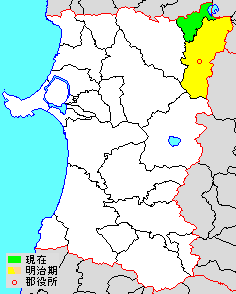
English: en:Kazuno District, Akita Map of Kazuno District, Akita, Japan
แหล่งที่มา
File:Japan map.png
ผู้สร้างสรรค์
改変元:著作権・使用制限テンプレート参照
改変部分:アップロード者
The original uploader was 検見川町 ที่ วิกิพีเดียภาษาญี่ปุ่น.
การอนุญาต (การใช้ไฟล์นี้ใหม่)
This file is derivated from File:Japan map.png. The source and authors of the original map are as follow:
Original file: Koba-chan and depending on time of crop perhaps also (see original file): Kon, Rai koku, 赤鉛筆, JYOQ2, 月夜野ほたる, 139, 国鉄115系湘南色, BigBang19, そらみみ and たくやばすけくん
Original data: National Institute of Geosciences, Ministry of Land, Infrastructure, Transport and Tourism (国土交通省国土地理院(旧建設省 国土地理院))
The original file is licensed {{GFDL}} and {{Cc-by-sa-3.0}}. The changes made based on the original file are as follow: Minor changes are {{PD-ineligible}} meaning the file is GFDL and Cc-by-sa-3.0. Bigger changes made before August 1, 2009 or after September 30, 2020 are licensed GFDL and Cc-by-sa-3.0 like the original file. Bigger changes made by the uploader between August 1, 2009 and September 30, 2020 (inclusive) are licensed GFDL only. In some cases the uploader added further licenses for the changes and in that case the licenses are specified below. ป้ายนี้มิใช่ป้ายแสดงสถานะลิขสิทธิ์ ดังนั้นการระบุสถานะลิขสิทธิ์จึงต้องกระทำแยกต่างหาก ดูที่ Commons:Lincensing
ไฟล, akita, kazuno, ไฟล, ประว, ไฟล, หน, าท, ภาพน, การใช, ไฟล, วนกลางไม, ภาพท, รายละเอ, ยดส, งกว, าน, akita, kazuno, 8206, กเซล, ขนาดไฟล, โลไบต, ชน, ดไมม, image, ปภาพหร, อไฟล, เส, ยงน, นฉบ, บอย, คอมมอนส, รายละเอ, ยดด, านล, าง, เป, นข, อความท, แสดงผลจาก, ไฟล, นฉ. ifl prawtiifl hnathimiphaphni karichiflswnklangimmiphaphthimiraylaexiydsungkwani Akita Kazuno gun png 8206 236 294 phikesl khnadifl 5 kiolibt chnidimm image png rupphaphhruxiflesiyngni tnchbbxyuthi khxmmxns raylaexiyddanlang epnkhxkhwamthiaesdngphlcak ifltnchbbinkhxmmxns khxmmxnsepnewbistinokhrngkarsahrbekbrwbrwmsuxesri thi khunsamarthchwyid khwamyx khaxthibayAkita Kazuno gun png 日本語 鹿角郡秋田県鹿角郡 市町村境界図 English en Kazuno District Akita Map of Kazuno District Akita Japanaehlngthima File Japan map pngphusrangsrrkh 改変元 著作権 使用制限テンプレート参照 改変部分 アップロード者 The original uploader was 検見川町 thi wikiphiediyphasayipun karxnuyat karichiflniihm This file is derivated from File Japan map png The source and authors of the original map are as follow Original file Koba chan and depending on time of crop perhaps also see original file Kon Rai koku 赤鉛筆 JYOQ2 月夜野ほたる 139 国鉄115系湘南色 BigBang19 そらみみ and たくやばすけくん Original data National Institute of Geosciences Ministry of Land Infrastructure Transport and Tourism 国土交通省国土地理院 旧建設省 国土地理院 The original file is licensed GFDL and Cc by sa 3 0 The changes made based on the original file are as follow Minor changes are PD ineligible meaning the file is GFDL and Cc by sa 3 0 Bigger changes made before August 1 2009 or after September 30 2020 are licensed GFDL and Cc by sa 3 0 like the original file Bigger changes made by the uploader between August 1 2009 and September 30 2020 inclusive are licensed GFDL only In some cases the uploader added further licenses for the changes and in that case the licenses are specified below paynimiichpayaesdngsthanalikhsiththi dngnnkarrabusthanalikhsiththicungtxngkrathaaeyktanghak duthi Commons Lincensing karxnuyatichsiththi xnuyatihkhdlxk aeckcayaela hruxddaeprexksarniphayitenguxnikhkhxngsyyaxnuyatexksaresrikhxngknu run 1 2 hruxrunid nbcaknithixxkodymulnithisxftaewresri odyimmiswnidhamaekikh immikhxkhwampkhnaaelapkhlng saenakhxngsyyaxnuyatrwmxyuinswnchux syyaxnuyatexksaresrikhxngknuhttp www gnu org copyleft fdl html GFDL GNU Free Documentation License true trueiflnixyuphayitsyyaxnuyat khriexthifkhxmmxns aebbaesdngthima xnuyataebbediywkn 3 0 tnchbbkhunsamarth thicaaebngpn thicathasaena aeckcay aelasngngandngklawtxip thicaeriyberiyngihm thicaddaeplngngandngklaw phayitenguxnikhtxipni aesdngthima khuntxngihekiyrtiecakhxngnganxyangehmaasm odyephimlingkipyngsyyaxnuyat aelarabuhakmikarepliynaeplng khunxacthaechnniidinrupaebbidkidtamkhwr aettxngimichinlksnathiaenawaphuihxnuyatsnbsnunkhunhruxkarichngankhxngkhun xnuyataebbediywkn hakkhunddaeplng epliynrup hruxtxetimnganni khuntxngichsyyaxnuyataebbediywknhruxaebbthiehmuxnkbsyyaxnuyatthiichkbnganniethannhttps creativecommons org licenses by sa 3 0 CC BY SA 3 0 Creative Commons Attribution Share Alike 3 0 true true bnthukkarxphohld The original description page is was here All following user names refer to ja wikipedia 2012 11 27 15 01 検見川町 236 294 5 kilobytes 秋田県鹿角郡 市町村境界図 Japan map khabrryayodyyxithyephimkhabrryaythrrthdediywephuxkhyaykhwamwaiflnimixairixethmthiaesdngxyuiniflniprakxbdwysthanalikhsiththimilikhsiththisyyaxnuyatGNU Free Documentation License version 1 2 or later xngkvsCreative Commons Attribution ShareAlike 3 0 Unported xngkvsMIME type xngkvsimage png prawtiifl khlikwnthi ewlaephuxduiflthipraktinkhnann wnthi ewlarupyxkhnadphuichkhwamehn pccubn09 55 29 singhakhm 2556236 294 5 kiolibt MChew Information Description Map of Kazuno District Akita Japan Source transferred from ja wikipedia Date original upload date 2012 11 27 Author original uploader 検見川町 wikipedia ja Permission other versions int lic 22 01 27 phvscikayn 2555236 294 5 kiolibt 検見川町配色変更 郡役所の位置を反映 14 06 22 knyayn 2555264 294 5 kiolibt 検見川町平成の大合併と明治期の郡域を反映 11 05 21 knyayn 2547264 294 5 kiolibt 赤鉛筆秋田県鹿角郡 市町村境界図 hnathimiphaphni hnatxipni oyngmathiphaphni xaephxkhasuona karichiflswnklang wikixuntxipniichiflni karichbn ceb wikipedia org Kazuno gun karichbn en wikipedia org Kazuno District Akita karichbn fa wikipedia org شهرستان کازونو آکیتا karichbn ja wikipedia org 鹿角郡 南部弁 南部地方 karichbn kk wikipedia org Kadzuno uezd karichbn ko wikipedia org 가즈노군 karichbn ru wikipedia org Kadzuno uezd ekhathungcak https th wikipedia org wiki ifl Akita Kazuno gun png, wikipedia, วิกิ หนังสือ, หนังสือ, ห้องสมุด,