This file is a map of a municipality in Japan created and uploaded by Lincun on Japanese Wikipedia. It may also be a file based on one of these maps (see info in file history or author field for more info on later editors). Source:
English: Data used : Ministry of Land, Infrastructure, Transport and Tourism - National Land Numerical Information (Administrative Area (N03) / Lake (W09))
日本語: 使用データ : 国土交通省 国土数値情報(行政区域(N03)・湖沼(W09))
The original file was licensed {{GFDL}} and {{Cc-by-sa-3.0}}. See this category for more files like this. ป้ายนี้มิใช่ป้ายแสดงสถานะลิขสิทธิ์ ดังนั้นการระบุสถานะลิขสิทธิ์จึงต้องกระทำแยกต่างหาก ดูที่ Commons:Lincensing
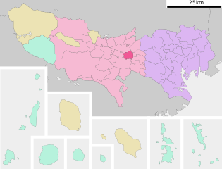
ไฟล, koganei, tokyo, prefecture, ไฟล, ประว, ไฟล, หน, าท, ภาพน, การใช, ไฟล, วนกลาง, อม, ลเก, ยวก, บภาพขนาดของต, วอย, าง, ของไฟล, กเซล, ความละเอ, ยดอ, กเซล, กเซล, กเซล, กเซล, กเซล, ภาพท, ความละเอ, ยดส, งกว, 8206, ไฟล, กเซล, ขนาดไฟล, โลไบต, ปภาพหร, อไฟล, เส, ยงน,. ifl prawtiifl hnathimiphaphni karichiflswnklang khxmulekiywkbphaphkhnadkhxngtwxyang PNG nikhxngifl SVG ni 786 599 phikesl khwamlaexiydxun 315 240 phikesl 630 480 phikesl 1 007 768 phikesl 1 280 976 phikesl 2 560 1 952 phikesl duphaphthimikhwamlaexiydsungkwa 8206 ifl SVG 800 610 phikesl khnadifl 42 kiolibt rupphaphhruxiflesiyngni tnchbbxyuthi khxmmxns raylaexiyddanlang epnkhxkhwamthiaesdngphlcak ifltnchbbinkhxmmxns khxmmxnsepnewbistinokhrngkarsahrbekbrwbrwmsuxesri thi khunsamarthchwyid khwamyx khaxthibayKoganei in Tokyo Prefecture Ja svg English Location of Koganei in Tokyo 日本語 ja 東京都小金井市位置図wnthi 12 knyayn ph s 2550 14 12 UTC aehlngthima Original file ngankhxngtw Data 国土交通省 国土数値情報 行政区域 N03 湖沼 W09 phusrangsrrkh Lincunkarxnuyat karichiflniihm This file is a map of a municipality in Japan created and uploaded by Lincun on Japanese Wikipedia It may also be a file based on one of these maps see info in file history or author field for more info on later editors Source English Data used Ministry of Land Infrastructure Transport and Tourism National Land Numerical Information Administrative Area N03 Lake W09 日本語 使用データ 国土交通省 国土数値情報 行政区域 N03 湖沼 W09 The original file was licensed GFDL and Cc by sa 3 0 See this category for more files like this paynimiichpayaesdngsthanalikhsiththi dngnnkarrabusthanalikhsiththicungtxngkrathaaeyktanghak duthi Commons Lincensing karxnuyatichsiththi xnuyatihkhdlxk aeckcayaela hruxddaeprexksarniphayitenguxnikhkhxngsyyaxnuyatexksaresrikhxngknu run 1 2 hruxrunid nbcaknithixxkodymulnithisxftaewresri odyimmiswnidhamaekikh immikhxkhwampkhnaaelapkhlng saenakhxngsyyaxnuyatrwmxyuinswnchux syyaxnuyatexksaresrikhxngknuhttp www gnu org copyleft fdl html GFDL GNU Free Documentation License true trueiflnixyuphayitsyyaxnuyat khriexthifkhxmmxns aebbaesdngthima xnuyataebbediywkn 3 0 tnchbbkhunsamarth thicaaebngpn thicathasaena aeckcay aelasngngandngklawtxip thicaeriyberiyngihm thicaddaeplngngandngklaw phayitenguxnikhtxipni aesdngthima khuntxngihekiyrtiecakhxngnganxyangehmaasm odyephimlingkipyngsyyaxnuyat aelarabuhakmikarepliynaeplng khunxacthaechnniidinrupaebbidkidtamkhwr aettxngimichinlksnathiaenawaphuihxnuyatsnbsnunkhunhruxkarichngankhxngkhun xnuyataebbediywkn hakkhunddaeplng epliynrup hruxtxetimnganni khuntxngichsyyaxnuyataebbediywknhruxaebbthiehmuxnkbsyyaxnuyatthiichkbnganniethannhttps creativecommons org licenses by sa 3 0 CC BY SA 3 0 Creative Commons Attribution Share Alike 3 0 true true bnthukkarxphohld This file was moved from Japanese Wikipedia See below for original file information File name 基礎自治体位置図 13210 svgDescription 基礎自治体位置図画像情報 東京都 小金井市 File history wnthi ewla UTC khnad phuich khwamehn12 knyayn ph s 2550 14 12 19 800x682 Lincun 基礎自治体位置図画像情報 東京都 小金井市 Page history wnthi ewla UTC Flag phuich khwamyx 12 knyayn ph s 2550 14 12 19 Lincun 基礎自治体位置図画像情報 東京都 小金井市 Deutsch English makedonski 한국어 日本語 فارسی khabrryayodyyxithyephimkhabrryaythrrthdediywephuxkhyaykhwamwaiflnimixairixethmthiaesdngxyuiniflniprakxbdwysthanalikhsiththimilikhsiththisyyaxnuyatCreative Commons Attribution ShareAlike 3 0 Unported xngkvsGNU Free Documentation License version 1 2 or later xngkvsMIME type xngkvsimage svg xml prawtiifl khlikwnthi ewlaephuxduiflthipraktinkhnann wnthi ewlarupyxkhnadphuichkhwamehn pccubn13 36 7 phvscikayn 2563800 610 42 kiolibt AichiWikiFixerUpdate 22 04 19 phvscikayn 2552800 682 23 kiolibt Monaneko Information Description en 1 Location of Koganei in Tokyo ja 1 東京都小金井市の位置 Source ja File 基礎自治体位置図 13210 svg Author ja User Lincun Date 2007 09 12 14 12 UTC Permission other versions C 21 12 12 knyayn 2550800 682 23 kiolibt Lincun 基礎自治体位置図画像情報 東京都 小金井市 hnathimiphaphni hnatxipni oyngmathiphaphni okhngaenxi karichiflswnklang wikixuntxipniichiflni karichbn ar wikipedia org كوغانه طوكيو karichbn arz wikipedia org كوجانى طوكيو karichbn azb wikipedia org کوقانی توکیو karichbn ca wikipedia org Koganei karichbn ce wikipedia org Koganei karichbn de wikipedia org Koganei karichbn el wikipedia org Kogkanei Tokio karichbn en wikipedia org Koganei Tokyo karichbn es wikipedia org Koganei Tokio karichbn eu wikipedia org Koganei karichbn fa wikipedia org منطقه تاما کوگانی توکیو karichbn fi wikipedia org Koganei karichbn gl wikipedia org Koganei karichbn id wikipedia org Koganei Tōkyō karichbn ja wikipedia org 小金井市 karichbn jv wikipedia org Tokyo karichbn ko wikipedia org 고가네이시 karichbn ms wikipedia org Koganei karichbn nl wikipedia org Koganei karichbn pl wikipedia org Tokio karichbn ro wikipedia org Koganei karichbn sr wikipedia org Koganeј karichbn sv wikipedia org Koganei karichbn tg wikipedia org Koganei karichbn tt wikipedia org Koganei karichbn uk wikipedia org Koganej karichbn vi wikipedia org Koganei Tokyo karichbn www wikidata org Q242874 karichbn zh min nan wikipedia org Koganei chhikhxmulekiywkbphaph phaphnimikhxmulephimetim sungswnihymacakklxngdicitxlhruxsaeknenxrthisamarthekbkhxmuldngklawiwrwmkbphaphid thaphaphnithukprbprungaekikhhruxepliynaeplngcakedim khxmulbangxyangcayngkhngimepliynaeplngehmuxnphaphthithukprbprungaekikhnnchuxeruxngsn東京都行政区画地図khwamkwang800pxkhwamsung610px ekhathungcak https th wikipedia org wiki ifl Koganei in Tokyo Prefecture Ja svg, wikipedia, วิกิ หนังสือ, หนังสือ, ห้องสมุด,