Alemannisch ∙ العربية ∙ беларуская (тарашкевіца) ∙ български ∙ বাংলা ∙ català ∙ нохчийн ∙ čeština ∙ dansk ∙ Deutsch ∙ Ελληνικά ∙ English ∙ British English ∙ Esperanto ∙ español ∙ eesti ∙ euskara ∙ فارسی ∙ suomi ∙ français ∙ Frysk ∙ galego ∙ עברית ∙ hrvatski ∙ magyar ∙ հայերեն ∙ Bahasa Indonesia ∙ Ido ∙ italiano ∙ 日本語 ∙ ქართული ∙ 한국어 ∙ lietuvių ∙ македонски ∙ മലയാളം ∙ Bahasa Melayu ∙ norsk bokmål ∙ Plattdüütsch ∙ Nederlands ∙ norsk nynorsk ∙ norsk ∙ occitan ∙ polski ∙ português ∙ português do Brasil ∙ română ∙ русский ∙ sicilianu ∙ Scots ∙ slovenčina ∙ slovenščina ∙ српски / srpski ∙ svenska ∙ தமிழ் ∙ ไทย ∙ Türkçe ∙ татарча/tatarça ∙ українська ∙ vèneto ∙ Tiếng Việt ∙ 中文(简体) ∙ 中文(繁體) ∙ +/−
ภาพนี้ ได้รับการปรับแต่งภาพ ซึ่งหมายความว่าจะได้รับการเปลี่ยนแปลงภาพต่างจากต้นฉบับ ต้นฉบับสามารถดูได้ที่นี่: Brazil location map.svg.
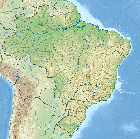
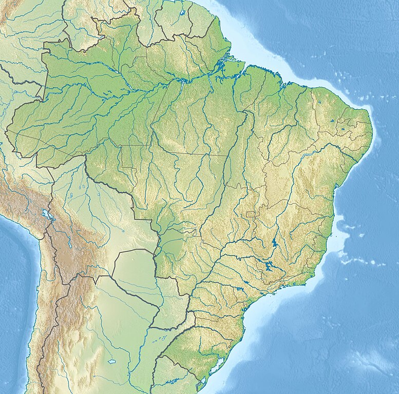
{{Information |Description={{en|Location map of Brazil}} Equirectangular projection, N/S stretching 105 %. Geographic limits of the map: * N: 6.0° N * S: 34.0° S * W: 74.5° W * E: 32.0° W |Source=*File:Brazil_location_map.svg
ไฟล, relief, brazil, ไฟล, ประว, ไฟล, หน, าท, ภาพน, การใช, ไฟล, วนกลาง, อม, ลเก, ยวก, บภาพขนาดของต, วอย, างน, กเซล, ความละเอ, ยดอ, กเซล, กเซล, กเซล, กเซล, ภาพท, ความละเอ, ยดส, งกว, 8206, กเซล, ขนาดไฟล, เมกะไบต, ชน, ดไมม, image, jpeg, ปภาพหร, อไฟล, เส, ยงน, นฉบ,. ifl prawtiifl hnathimiphaphni karichiflswnklang khxmulekiywkbphaphkhnadkhxngtwxyangni 607 600 phikesl khwamlaexiydxun 243 240 phikesl 486 480 phikesl 777 768 phikesl 1 200 1 186 phikesl duphaphthimikhwamlaexiydsungkwa 8206 1 200 1 186 phikesl khnadifl 1 05 emkaibt chnidimm image jpeg rupphaphhruxiflesiyngni tnchbbxyuthi khxmmxns raylaexiyddanlang epnkhxkhwamthiaesdngphlcak ifltnchbbinkhxmmxns khxmmxnsepnewbistinokhrngkarsahrbekbrwbrwmsuxesri thi khunsamarthchwyid khaxthibayRelief Map of Brazil jpg English Location map of Brazil Equirectangular projection N S stretching 105 Geographic limits of the map N 6 0 N S 34 0 S W 74 5 W E 32 0 Wwnthi 27 phvscikayn ph s 2553 17 53 UTC aehlngthima Brazil location map svg SRTM30 ETOPO1phusrangsrrkh Brazil location map svg NordNordWest derivative work Viktor V talk ewxrchnxun phaphnimiphaphinrupaebbewketxr SVG hakphaph SVG thaihkaraesdngphldikwa hnathiichphaphnikhwrepliynipichphaph SVG aethn File Relief Map of Brazil jpg File Relief Map of Brazil svg sahrbkhxmulephimetimekiywkbphaphewketxr duthi karepliynipichphaph SVG inkhxmmxnsnxkcaknisamarthduephimetimekiywkb khxmulekiywkbkarrxngrbphaph SVG sahrbsxftaewrmiediywiki id inphasaxunAlemannisch العربية belaruskaya tarashkevica blgarski ব ল catala nohchijn cestina dansk Deutsch Ellhnika English British English Esperanto espanol eesti euskara فارسی suomi francais Frysk galego עברית hrvatski magyar հայերեն Bahasa Indonesia Ido italiano 日本語 ქართული 한국어 lietuviu makedonski മലയ ള Bahasa Melayu norsk bokmal Plattduutsch Nederlands norsk nynorsk norsk occitan polski portugues portugues do Brasil romană russkij sicilianu Scots slovencina slovenscina srpski srpski svenska தம ழ ithy Turkce tatarcha tatarca ukrayinska veneto Tiếng Việt 中文 简体 中文 繁體 phaphni idrbkarprbaetngphaph sunghmaykhwamwacaidrbkarepliynaeplngphaphtangcaktnchbb tnchbbsamarthduidthini Brazil location map svg khapheca inthanaphuthuxlikhsiththikhxngphaphhruxsuxni xnuyatihichphaphhruxsuxniphayitenguxnikhtxipniiflnixyuphayitsyyaxnuyat khriexthifkhxmmxns aebbaesdngthima xnuyataebbediywkn 3 0 tnchbbkhunsamarth thicaaebngpn thicathasaena aeckcay aelasngngandngklawtxip thicaeriyberiyngihm thicaddaeplngngandngklaw phayitenguxnikhtxipni aesdngthima khuntxngihekiyrtiecakhxngnganxyangehmaasm odyephimlingkipyngsyyaxnuyat aelarabuhakmikarepliynaeplng khunxacthaechnniidinrupaebbidkidtamkhwr aettxngimichinlksnathiaenawaphuihxnuyatsnbsnunkhunhruxkarichngankhxngkhun xnuyataebbediywkn hakkhunddaeplng epliynrup hruxtxetimnganni khuntxngichsyyaxnuyataebbediywknhruxaebbthiehmuxnkbsyyaxnuyatthiichkbnganniethannhttps creativecommons org licenses by sa 3 0 CC BY SA 3 0 Creative Commons Attribution Share Alike 3 0 true true bnthukkarxphohld This image is a derivative work of the following images File Brazil location map svg licensed with Cc by sa 3 0 2009 08 05T19 53 55Z NordNordWest 2008x1984 1674058 Bytes int filedesc Information Description de Positionskarte von de Brasilien Brasilien Quadratische Plattkarte N S Streckung 105 Geographische Begrenzung der Karte N 6 0 N S 34 0 S W 74 5 W OUploaded with derivativeFXkhabrryayodyyxithyephimkhabrryaythrrthdediywephuxkhyaykhwamwaiflnimixairixethmthiaesdngxyuiniflniprakxbdwysthanalikhsiththimilikhsiththisyyaxnuyatCreative Commons Attribution ShareAlike 3 0 Unported xngkvs prawtiifl khlikwnthi ewlaephuxduiflthipraktinkhnann wnthi ewlarupyxkhnadphuichkhwamehn pccubn04 46 15 phvsphakhm 25601 200 1 186 1 05 emkaibt JanitoalevicAdded Rincon de Artigas disputed territory 00 55 28 phvscikayn 25531 200 1 186 492 kiolibt Viktor V Information Description en Location map of Brazil Equirectangular projection N S stretching 105 Geographic limits of the map N 6 0 N S 34 0 S W 74 5 W E 32 0 W Source File Brazil location map svg hnathimiphaphni hnatxipni oyngmathiphaphni kurichiba natkxikwasu laokwamiring hiwbrngku esaluych mxdul Location map data Brazil mxdul Location map data Brazil doc karichiflswnklang wikixuntxipniichiflni karichbn als wikipedia org Vorlage Positionskarte Brasilien Vorlage Positionskarte Brasilien Parana karichbn an wikipedia org Rio Paraguacu karichbn ar wikipedia org غابة الأمازون قالب خريطة مواقع البرازيل جامعة ميناس جيرايس الاتحادية نهر تشابيكو نهر تشابيكزينهو karichbn arz wikipedia org قالب Location map Brazil قالب Location map Brazil doc قالب Infobox river قالب Infobox river doc karichbn az wikipedia org Sablon Yer xeritesi Braziliya Iquasu selale Serra du Mar Marajo Tupinambarana Bananal San Paulu adalari Grande de Gurupa Keymada Qrandi adasi Madeyra cayi Santa Katarina adasi Araquaya cayi Jurunea cayi Mamore cayi Sinqu cayi Tokantins cayi Tapajos cayi Telis Piris Rokas atolu Fernandu di Noronya Riu Qrandi Parana Paranaiba cayi Iriri Patus golu Laqoa Mirin Pantanal Putumayo Riu Branku Riu Neqru Piranyas cayi Taduz us Santus korfezi Paraiba du Sul cayi Sobradinyu su anbari Rodriqu di Freytas Quayra selalesi Bandeyra dagi Neblina dagi Aqulyas Neqras dagi Toka da Boa Vista magara dukarichthwolkephimetimkhxngiflnikhxmulekiywkbphaph phaphnimikhxmulephimetim sungswnihymacakklxngdicitxlhruxsaeknenxrthisamarthekbkhxmuldngklawiwrwmkbphaphid thaphaphnithukprbprungaekikhhruxepliynaeplngcakedim khxmulbangxyangcayngkhngimepliynaeplngehmuxnphaphthithukprbprungaekikhnnheight1 186width1 200khwamlaexiydaenwnxn53 79719543457 dpikhwamlaexiydaenwtng53 79719543457 dpisxftaewrthiichpaint net 4 0 13aekikhphaphlasud20 50 27 phvscikayn 2553 ekhathungcak https th wikipedia org wiki ifl Relief Map of Brazil jpg, wikipedia, วิกิ หนังสือ, หนังสือ, ห้องสมุด,