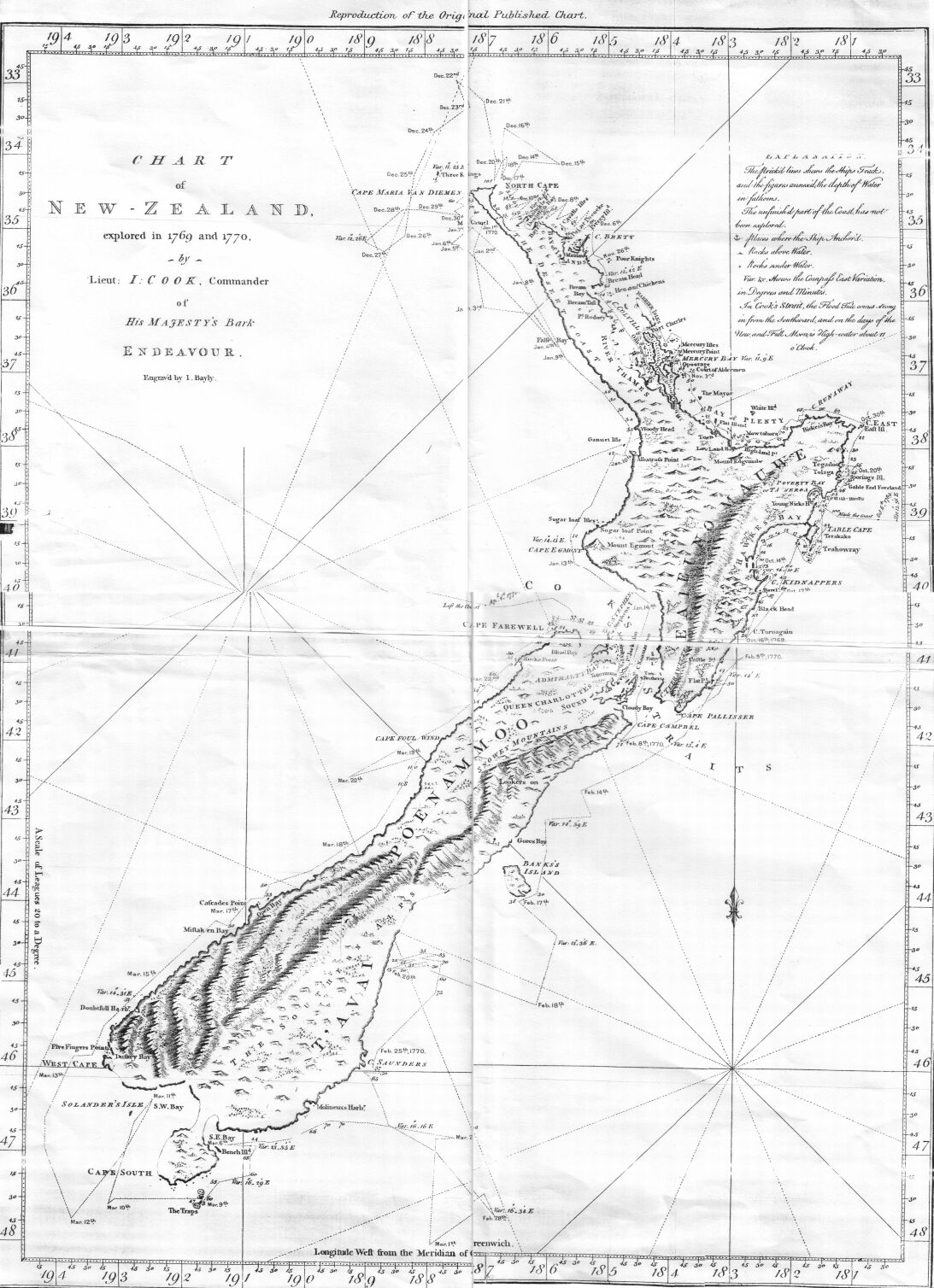
This is an image of a chart of New Zealand made by Lieutenant (later Captain Sir) James Cook during his 1770 voyage of exploration in the Pacific in command of HM Bark Endeavour.
วันที่
แหล่งที่มา
Taken from the Project Gutenberg edition of Captain Cook's Journal, First Voyage, which is based on an 1893 publication of Cook's original manuscript
ผู้สร้างสรรค์
James Cook
การอนุญาต (การใช้ไฟล์นี้ใหม่)
It is in the public domain worldwide
การอนุญาตใช้สิทธิ
Public domainPublic domainfalsefalse
https://creativecommons.org/publicdomain/mark/1.0/PDMCreative Commons Public Domain Mark 1.0falsefalse
Grabado de John Bayly del mapa de Nueva Zelanda realizado por James Cook y su sobrino Isaac Smith, con el recorrido del HMB Endeavour alrededor de las dos grandes islas neozelandesas y publicado por John Hawkesworth en 1773.
== Summary == {{Information |Description=This is an image of a chart of New Zealand made by Lieutenant (later Captain Sir) James Cook during his 1770 voyage of exploration in the Pacific in command of HM Bark ''Endeavour''. |Source=Taken from the
ไฟล, cook, chart, zealand, ไฟล, ประว, ไฟล, หน, าท, ภาพน, การใช, ไฟล, วนกลาง, อม, ลเก, ยวก, บภาพขนาดของต, วอย, างน, กเซล, ความละเอ, ยดอ, กเซล, กเซล, กเซล, กเซล, ภาพท, ความละเอ, ยดส, งกว, 8206, กเซล, ขนาดไฟล, โลไบต, ชน, ดไมม, image, jpeg, ปภาพหร, อไฟล, เส, ยงน, . ifl prawtiifl hnathimiphaphni karichiflswnklang khxmulekiywkbphaphkhnadkhxngtwxyangni 434 599 phikesl khwamlaexiydxun 174 240 phikesl 348 480 phikesl 557 768 phikesl 1 093 1 508 phikesl duphaphthimikhwamlaexiydsungkwa 8206 1 093 1 508 phikesl khnadifl 301 kiolibt chnidimm image jpeg rupphaphhruxiflesiyngni tnchbbxyuthi khxmmxns raylaexiyddanlang epnkhxkhwamthiaesdngphlcak ifltnchbbinkhxmmxns khxmmxnsepnewbistinokhrngkarsahrbekbrwbrwmsuxesri thi khunsamarthchwyid khwamyx khaxthibayCook chart of New Zealand jpg This is an image of a chart of New Zealand made by Lieutenant later Captain Sir James Cook during his 1770 voyage of exploration in the Pacific in command of HM Bark Endeavour wnthi 2312 hrux 2313 aehlngthima Taken from the Project Gutenberg edition of Captain Cook s Journal First Voyage which is based on an 1893 publication of Cook s original manuscript phusrangsrrkh James Cook karxnuyat karichiflniihm It is in the public domain worldwide karxnuyatichsiththi Public domain Public domain false false nganniepnsatharnsmbti inpraethstnkaenidaelapraethsxun thirayaewlakarkhumkhrxnglikhsiththinxykwa 100 pihlngcakphusrangsrrkhnganesiychiwit nxkcaknikhunxactxngephimpaysatharnsmbtiinshrthxemrika ephuxrabuwaehtuidngannicungepnsatharnsmbtiinshrthxemrika iflniidthukrabuwaimmikhxcakdphayitkdhmaylikhsiththi rwmthungsiththithiekiywkhxngaelathiiklekhiyngknhttps creativecommons org publicdomain mark 1 0 PDM Creative Commons Public Domain Mark 1 0 false falsekhabrryayodyyxithyephimkhabrryaythrrthdediywephuxkhyaykhwamwaiflnimixairsepnGrabado de John Bayly del mapa de Nueva Zelanda realizado por James Cook y su sobrino Isaac Smith con el recorrido del HMB Endeavour alrededor de las dos grandes islas neozelandesas y publicado por John Hawkesworth en 1773 ixethmthiaesdngxyuiniflniprakxbdwywnthisrang wnkxtng1770MIME type nbsp xngkvsimage jpeg prawtiifl khlikwnthi ewlaephuxduiflthipraktinkhnann wnthi ewlarupyxkhnadphuichkhwamehn pccubn09 59 27 knyayn 25491 093 1 508 301 kiolibt Hesperian Summary Information Description This is an image of a chart of New Zealand made by Lieutenant later Captain Sir James Cook during his 1770 voyage of exploration in the Pacific in command of HM Bark 039 039 Endeavour 039 039 Source Taken from the hnathimiphaphni hnatxipni oyngmathiphaphni phumisastr karichiflswnklang wikixuntxipniichiflni karichbn cs wikipedia org Novy Zeland Prvni plavba Jamese Cooka Dejiny Noveho Zelandu karichbn cy wikipedia org Defnyddiwr MatthewDavenport1985 Daearyddiaeth 1 Defnyddiwr MatthewDavenport1985 Daearyddiaeth 2 karichbn de wikipedia org North Cape Neuseeland karichbn en wikipedia org History of New Zealand New Zealand Geography Cartography of New Zealand User Lbothwe New Zealand karichbn es wikipedia org Primer viaje de James Cook Usuario Orestes 71 Taller Circunnavegacion de Nueva Zelanda por James Cook con el HMB Endeavour karichbn hu wikipedia org James Cook elso utja karichbn ko wikipedia org 뉴질랜드 karichbn pa wikipedia org ਨ ਊਜ ਲ ਡ karichbn pl wikipedia org Zatoka Pegaza Historia geografii Polwysep Banksa karichbn pnb wikipedia org نیوزیلینڈ karichbn sk wikipedia org Prva plavba Jamesa Cooka karichbn ur wikipedia org نیوزی لینڈkhxmulekiywkbphaph phaphnimikhxmulephimetim sungswnihymacakklxngdicitxlhruxsaeknenxrthisamarthekbkhxmuldngklawiwrwmkbphaphid thaphaphnithukprbprungaekikhhruxepliynaeplngcakedim khxmulbangxyangcayngkhngimepliynaeplngehmuxnphaphthithukprbprungaekikhnn error0 ekhathungcak https th wikipedia org wiki ifl Cook chart of New Zealand jpg, wikipedia, วิกิ หนังสือ, หนังสือ, ห้องสมุด,