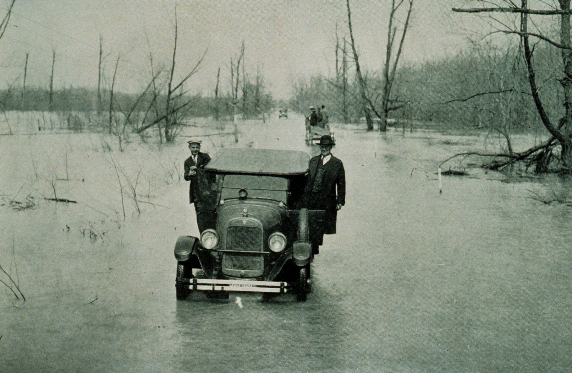
คำอธิบาย1927 Mississippi flood Mounds-Cairo IL highway.jpg
The Great Mississippi Flood of 1927, U.S. Route 51 between Mounds, Illinois, and Cairo, Illinois. River stage at Cairo, 52.8 feet. From "The Floods of 1927 in the Mississippi Basin", Frankenfeld, H.C., 1927 Monthly Weather Review Supplement No. 29.
วันที่
แหล่งที่มา
NOAA photo library filename wea00735: originally at [1] (now at [2])
ผู้สร้างสรรค์
Archival Photography by Steve Nicklas, NOS, NGS
การอนุญาต (การใช้ไฟล์นี้ใหม่)
Public domainPublic domainfalsefalse
เวอร์ชันอื่น
File:1927 Mississippi flood Mounds-Cairo IL highway.jpg
{{Information |Description=The Great Mississippi River Flood of 1927 Highway between Mounds, Illinois, and Cairo Illinois, March 25, 1927 - river stage at Cairo, Illinois., 52.8 feet From: "The Floods of 1927 in the Mississippi Basin", Frankenfeld, H.C.,
ไฟล, 1927, mississippi, flood, mounds, cairo, highway, ไฟล, ประว, ไฟล, หน, าท, ภาพน, การใช, ไฟล, วนกลางขนาดของต, วอย, างน, กเซล, ความละเอ, ยดอ, กเซล, กเซล, กเซล, กเซล, กเซล, ภาพท, ความละเอ, ยดส, งกว, 8206, กเซล, ขนาดไฟล, โลไบต, ชน, ดไมม, image, jpeg, ปภาพหร, อ. ifl prawtiifl hnathimiphaphni karichiflswnklangkhnadkhxngtwxyangni 800 522 phikesl khwamlaexiydxun 320 209 phikesl 640 418 phikesl 1 024 668 phikesl 1 280 836 phikesl 1 820 1 188 phikesl duphaphthimikhwamlaexiydsungkwa 8206 1 820 1 188 phikesl khnadifl 421 kiolibt chnidimm image jpeg rupphaphhruxiflesiyngni tnchbbxyuthi khxmmxns raylaexiyddanlang epnkhxkhwamthiaesdngphlcak ifltnchbbinkhxmmxns khxmmxnsepnewbistinokhrngkarsahrbekbrwbrwmsuxesri thi khunsamarthchwyid khaxthibay1927 Mississippi flood Mounds Cairo IL highway jpg The Great Mississippi Flood of 1927 U S Route 51 between Mounds Illinois and Cairo Illinois River stage at Cairo 52 8 feet From The Floods of 1927 in the Mississippi Basin Frankenfeld H C 1927 Monthly Weather Review Supplement No 29 wnthi 25 minakhm ph s 2469 aehlngthima NOAA photo library filename wea00735 originally at 1 now at 2 phusrangsrrkh Archival Photography by Steve Nicklas NOS NGS karxnuyat karichiflniihm Public domain Public domain false false This image is in the public domain because it contains materials that originally came from the U S National Oceanic and Atmospheric Administration taken or made as part of an employee s official duties العربية nbsp cestina nbsp Deutsch nbsp Zazaki nbsp English nbsp espanol nbsp eesti nbsp suomi nbsp francais nbsp hrvatski nbsp magyar nbsp italiano nbsp 日本語 nbsp 한국어 nbsp makedonski nbsp മലയ ള nbsp Plattduutsch nbsp Nederlands nbsp polski nbsp portugues nbsp romană nbsp russkij nbsp sicilianu nbsp slovenscina nbsp Turkce nbsp Tiếng Việt nbsp 简体中文 nbsp 繁體中文 nbsp ewxrchnxun File 1927 Mississippi flood Mounds Cairo IL highway jpgkhabrryayodyyxithyephimkhabrryaythrrthdediywephuxkhyaykhwamwaiflnimixairixethmthiaesdngxyuiniflniprakxbdwywnthisrang wnkxtng25 minakhm 1927krikxeriynMIME type nbsp xngkvsimage jpegchecksum nbsp xngkvs57dd3a131562aff28f918c984667168755d03fdfwithikarkahnd SHA 1 nbsp xngkvsdata size nbsp xngkvs431 076 ibtkhwamsung1 188 phikeslkhwamkwang1 820 phikesl prawtiifl khlikwnthi ewlaephuxduiflthipraktinkhnann wnthi ewlarupyxkhnadphuichkhwamehn pccubn18 56 30 thnwakhm 25491 820 1 188 421 kiolibt Wisekwai Information Description The Great Mississippi River Flood of 1927 Highway between Mounds Illinois and Cairo Illinois March 25 1927 river stage at Cairo Illinois 52 8 feet From The Floods of 1927 in the Mississippi Basin Frankenfeld H C hnathimiphaphni hnatxipni oyngmathiphaphni thanghlwngshrthhmayelkh 51 karichiflswnklang wikixuntxipniichiflni karichbn de wikipedia org Klimaextreme in Nordamerika karichbn en wikipedia org U S Route 51 User talk Wisekwai Reconstruction of New Orleans User Wisekwai User Wisekwai Message karichbn en wikinews org User Wisekwai enwikinews Message karichbn es wikipedia org Lluvia karichbn fr wikipedia org 1927 aux Etats Unis karichbn he wiktionary org הציף ekhathungcak https th wikipedia org wiki ifl 1927 Mississippi flood Mounds Cairo IL highway jpg, wikipedia, วิกิ หนังสือ, หนังสือ, ห้องสมุด,