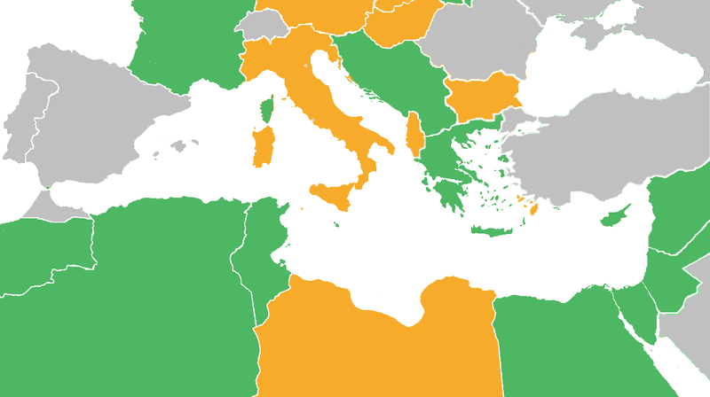
Dark Green: Allies before the attack on Pearl Harbor, including colonies and occupied countries.
Light Green: Allied countries that entered the war after the Japanese attack on Pearl Harbor.
Orange: Axis Powers
Gray: Neutral countries during WWII
Light green dots represent countries that later in the war changed from the Axis to the Allies
Orange dots represent countries that after being conquered by the Axis Powers, became puppets of those (Vichy France and several French colonies, Croatia, Greece)
วันที่
แหล่งที่มา
derived from Image:BlankMap-World6.svg
ผู้สร้างสรรค์
derived from User:Canuckguy's map
การอนุญาตใช้สิทธิ
Reuv at the English Wikipedia ในฐานะผู้ถือลิขสิทธิ์ของภาพหรือสื่อนี้ อนุญาตให้ใช้ภาพหรือสื่อนี้ภายใต้เงื่อนไขต่อไปนี้
The original description page was here. All following user names refer to en.wikipedia.
2011-06-21 03:34 Theirrulez 800×448× (125554 bytes) Borders corrections for Italy, Vichy's Government and Turkey
2009-07-18 07:32 Reuv 1305×731× (28321 bytes) Adressed the problems brought up in discussion.
2007-10-14 14:29 Reuv 1305×731× (45623 bytes) == Summary == {{Information |Description= map of the Mediterranean theatre of operations in WWII. |Source= derived from [[:Image:BlankMap-World6.svg|Image:BlankMap-World6.svg]] |Date= October 2007 |Author= derived from [[User:Canuckguy]]'s map |Permission
{{Information |Description=Maps of Mediterranean operations in World War II |Source=http://en.wikipedia.org/wiki/File:WWII-Mediterranean-v1.PNG |Date=10/2007 |Author=http://en.wikipedia.org/wiki/User:Canuckguy |Permission= |other_versions= }}
ไฟล, wwii, mediterranean, ไฟล, ประว, ไฟล, หน, าท, ภาพน, การใช, ไฟล, วนกลาง, อม, ลเก, ยวก, บภาพไม, ภาพท, รายละเอ, ยดส, งกว, าน, wwii, mediterranean, 8206, กเซล, ขนาดไฟล, โลไบต, ชน, ดไมม, image, ปภาพหร, อไฟล, เส, ยงน, นฉบ, บอย, คอมมอนส, รายละเอ, ยดด, านล, าง, เป. ifl prawtiifl hnathimiphaphni karichiflswnklang khxmulekiywkbphaphimmiphaphthimiraylaexiydsungkwani WWII Mediterranean v1 PNG 8206 800 448 phikesl khnadifl 113 kiolibt chnidimm image png rupphaphhruxiflesiyngni tnchbbxyuthi khxmmxns raylaexiyddanlang epnkhxkhwamthiaesdngphlcak ifltnchbbinkhxmmxns khxmmxnsepnewbistinokhrngkarsahrbekbrwbrwmsuxesri thi khunsamarthchwyid khwamyx khaxthibayWWII Mediterranean v1 PNG Map with the Participants in World War II Dark Green Allies before the attack on Pearl Harbor including colonies and occupied countries Light Green Allied countries that entered the war after the Japanese attack on Pearl Harbor Orange Axis Powers Gray Neutral countries during WWII Light green dots represent countries that later in the war changed from the Axis to the Allies Orange dots represent countries that after being conquered by the Axis Powers became puppets of those Vichy France and several French colonies Croatia Greece wnthi tulakhm ph s 2550 aehlngthima derived from Image BlankMap World6 svg phusrangsrrkh derived from User Canuckguy s map karxnuyatichsiththi Reuv at the English Wikipedia inthanaphuthuxlikhsiththikhxngphaphhruxsuxni xnuyatihichphaphhruxsuxniphayitenguxnikhtxipni xnuyatihkhdlxk aeckcayaela hruxddaeprexksarniphayitenguxnikhkhxngsyyaxnuyatexksaresrikhxngknu run 1 2 hruxrunid nbcaknithixxkodymulnithisxftaewresri odyimmiswnidhamaekikh immikhxkhwampkhnaaelapkhlng saenakhxngsyyaxnuyatrwmxyuinswnchux syyaxnuyatexksaresrikhxngknuhttp www gnu org copyleft fdl html GFDL GNU Free Documentation License true true iflnixyuphayitsyyaxnuyat khriexthifkhxmmxns aebbaesdngthima xnuyataebbediywkn 3 0 tnchbb karaesdngthima Reuv at the English Wikipedia khunsamarth thicaaebngpn thicathasaena aeckcay aelasngngandngklawtxip thicaeriyberiyngihm thicaddaeplngngandngklaw phayitenguxnikhtxipni aesdngthima khuntxngihekiyrtiecakhxngnganxyangehmaasm odyephimlingkipyngsyyaxnuyat aelarabuhakmikarepliynaeplng khunxacthaechnniidinrupaebbidkidtamkhwr aettxngimichinlksnathiaenawaphuihxnuyatsnbsnunkhunhruxkarichngankhxngkhun xnuyataebbediywkn hakkhunddaeplng epliynrup hruxtxetimnganni khuntxngichsyyaxnuyataebbediywknhruxaebbthiehmuxnkbsyyaxnuyatthiichkbnganniethann payaesdngsthanalikhsiththinithukephimephuxihepniptamkarepliynaeplngsyyaxnuyatkhxngmulnithiwikimiediy cak GFDL ipyng GFDL khwbkhukb CC BY SA 3 0 http creativecommons org licenses by sa 3 0 CC BY SA 3 0 Creative Commons Attribution Share Alike 3 0 true true bnthukkarxphohld The original description page was here All following user names refer to en wikipedia 2011 06 21 03 34 Theirrulez 800 448 125554 bytes Borders corrections for Italy Vichy s Government and Turkey 2009 07 18 07 32 Reuv 1305 731 28321 bytes Adressed the problems brought up in discussion 2007 10 14 14 29 Reuv 1305 731 45623 bytes Summary Information Description map of the Mediterranean theatre of operations in WWII Source derived from Image BlankMap World6 svg Image BlankMap World6 svg Date October 2007 Author derived from User Canuckguy s map PermissionkhabrryayodyyxithyephimkhabrryaythrrthdediywephuxkhyaykhwamwaiflnimixairixethmthiaesdngxyuiniflniprakxbdwysthanalikhsiththimilikhsiththisyyaxnuyatCreative Commons Attribution ShareAlike 3 0 Unported nbsp xngkvsGNU Free Documentation License version 1 2 or later nbsp xngkvswnthisrang wnkxtngtulakhm 2007MIME type nbsp xngkvsimage png prawtiifl khlikwnthi ewlaephuxduiflthipraktinkhnann wnthi ewlarupyxkhnadphuichkhwamehn pccubn22 22 10 phvsphakhm 2555800 448 113 kiolibt OgreBot BOT Reverting to most recent version before archival 22 22 10 phvsphakhm 25551 305 731 28 kiolibt OgreBot BOT Uploading old version of file from en wikipedia originally uploaded on 2009 07 18 07 32 35 by Reuv 22 22 10 phvsphakhm 25551 305 731 45 kiolibt OgreBot BOT Uploading old version of file from en wikipedia originally uploaded on 2007 10 14 14 29 14 by Reuv 00 20 28 tulakhm 2554800 448 113 kiolibt Spiridon Ion CepleanuRectifications borders 1940 1940 before June 1940 and countrie 039 s status 23 25 21 mithunayn 2554800 448 123 kiolibt Gigillo83Borders I YU 00 33 21 mithunayn 2554800 448 123 kiolibt Gigillo83Borders corrections for Italy Vichy 039 s Government and Turkey 18 59 7 tulakhm 2552800 448 111 kiolibt JJ Georges Information Description Maps of Mediterranean operations in World War II Source http en wikipedia org wiki File WWII Mediterranean v1 PNG Date 10 2007 Author http en wikipedia org wiki User Canuckguy Permission other versions hnathimiphaphni hnatxipni oyngmathiphaphni ekhtsngkhramemdietxrereniynaelatawnxxkklanginsngkhramolkkhrngthisxng karichiflswnklang wikixuntxipniichiflni karichbn ar wikipedia org مسرح عمليات المتوسط والشرق الأوسط في الحرب العالمية الثانية karichbn ca wikipedia org Escenaris de la Mediterrania l Orient Mitja i l Africa de la Segona Guerra Mundial karichbn en wikipedia org Mediterranean and Middle East theatre of World War II Louis Edward Curdes User Fgnievinski test Talk World War II Summary style karichbn eo wikipedia org Batalfronto de Mediteraneo Proksima Oriento kaj Afriko dua mondmilito karichbn es wikipedia org Batalla del Mediterraneo karichbn eu wikipedia org Bigarren Mundu Gerrako Mediterraneoko eta Ekialde Hurbileko frontea karichbn fa wikipedia org جبهه های مدیترانه خاورمیانه و آفریقا karichbn fi wikipedia org Valimeren Lahi idan ja Afrikan sotatoimialue toisessa maailmansodassa karichbn fr wikipedia org Campagne de la Mediterranee karichbn he wikipedia org הקרב על הים התיכון משתמש בראנד הזירה האיטלקית זירת הים התיכון במלחמת העולם השנייה karichbn hr wikipedia org Mediteransko i bliskoistocno bojiste Drugi svjetski rat karichbn it wikipedia org Progetto Laboratorio grafico Immagini da migliorare Archivio risolte 83 karichbn ko wikipedia org 제2차 세계 대전의 지중해 및 중동 전구 지중해 해전 제2차 세계 대전 karichbn lt wikipedia org Vidurzemio juros karas karichbn ms wikipedia org Perang Dunia II Kancah Mediterranean dan Timur Tengah karichbn no wikipedia org Kampen om Middelhavet karichbn ru wikipedia org Bitva za Sredizemnomore 1940 1943 karichbn sr wikipedia org Mediteranski i bliskoistocni front Drugog svetskog rata karichbn ta wikipedia org நட ந லக கடல சண ட நட ந லக கடல மத த ய க ழக க மற ற ம ஆப ப ர க க களம karichbn tr wikipedia org Ikinci Dunya Savasi nin Akdeniz ve Orta Dogu askeri sahalari karichbn vi wikipedia org Chiến trường Địa Trung Hải va Trung Đong Thế chiến thứ hai karichbn zh wikipedia org 地中海戰役 第二次世界大戰地中海 中東及非洲戰場khxmulekiywkbphaph phaphnimikhxmulephimetim sungswnihymacakklxngdicitxlhruxsaeknenxrthisamarthekbkhxmuldngklawiwrwmkbphaphid thaphaphnithukprbprungaekikhhruxepliynaeplngcakedim khxmulbangxyangcayngkhngimepliynaeplngehmuxnphaphthithukprbprungaekikhnnkhwamlaexiydaenwnxn28 35 dpckhwamlaexiydaenwtng28 35 dpc ekhathungcak https th wikipedia org wiki ifl WWII Mediterranean v1 PNG, wikipedia, วิกิ หนังสือ, หนังสือ, ห้องสมุด,