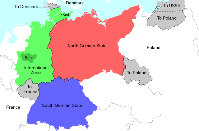
English: Map of the 1944 Morgenthau Plan, which would have seen Germany totally demilitarised and divided into three areas: a Northern state, a Southern state, and a de-industrialised International Zone in the west, administered by "an international security organization, to be established by the United Nations". The International Zone included the Ruhr area, regarded as Germany's industrial heartland, and the important naval port of Kiel. The intention was to prevent Germany from ever again being able to develop military industry or wage war. In addition, the Saar region and surrounding area was to be ceded to France; most of Silesia and southern East Prussia to Poland; northern East Prussia to the USSR; and northern Schleswig to Denmark.
ไฟล, morgenthau, plan, ไฟล, ประว, ไฟล, หน, าท, ภาพน, การใช, ไฟล, วนกลาง, อม, ลเก, ยวก, บภาพขนาดของต, วอย, าง, ของไฟล, กเซล, ความละเอ, ยดอ, กเซล, กเซล, กเซล, กเซล, กเซล, ภาพท, ความละเอ, ยดส, งกว, 8206, ไฟล, กเซล, ขนาดไฟล, โลไบต, ปภาพหร, อไฟล, เส, ยงน, นฉบ, บอย,. ifl prawtiifl hnathimiphaphni karichiflswnklang khxmulekiywkbphaphkhnadkhxngtwxyang PNG nikhxngifl SVG ni 671 442 phikesl khwamlaexiydxun 320 211 phikesl 640 422 phikesl 1 024 675 phikesl 1 280 843 phikesl 2 560 1 686 phikesl duphaphthimikhwamlaexiydsungkwa 8206 ifl SVG 671 442 phikesl khnadifl 132 kiolibt rupphaphhruxiflesiyngni tnchbbxyuthi khxmmxns raylaexiyddanlang epnkhxkhwamthiaesdngphlcak ifltnchbbinkhxmmxns khxmmxnsepnewbistinokhrngkarsahrbekbrwbrwmsuxesri thi khunsamarthchwyid khwamyx khaxthibayMorgenthau Plan map svg English Map of the 1944 Morgenthau Plan which would have seen Germany totally demilitarised and divided into three areas a Northern state a Southern state and a de industrialised International Zone in the west administered by an international security organization to be established by the United Nations The International Zone included the Ruhr area regarded as Germany s industrial heartland and the important naval port of Kiel The intention was to prevent Germany from ever again being able to develop military industry or wage war In addition the Saar region and surrounding area was to be ceded to France most of Silesia and southern East Prussia to Poland northern East Prussia to the USSR and northern Schleswig to Denmark wnthi 31 krkdakhm ph s 2563 aehlngthima ngankhxngtw phusrangsrrkh Erinthecute SVG nbsp genesisInfoField nbsp sxrsokhdkhxng SVG nitrwcsxbthuktxngaelw nbsp iflphaphkrafiksewketxrni srangkhunodyich nbsp Inkscape nbsp This map uses embedded text nbsp that can be easily translated using a text editor karxnuyatichsiththi khapheca inthanaphuthuxlikhsiththikhxngphaphhruxsuxni xnuyatihichphaphhruxsuxniphayitenguxnikhtxipniiflnixyuphayitsyyaxnuyat khriexthifkhxmmxns aebbaesdngthima xnuyataebbediywkn 4 0 nanachatikhunsamarth thicaaebngpn thicathasaena aeckcay aelasngngandngklawtxip thicaeriyberiyngihm thicaddaeplngngandngklaw phayitenguxnikhtxipni aesdngthima khuntxngihekiyrtiecakhxngnganxyangehmaasm odyephimlingkipyngsyyaxnuyat aelarabuhakmikarepliynaeplng khunxacthaechnniidinrupaebbidkidtamkhwr aettxngimichinlksnathiaenawaphuihxnuyatsnbsnunkhunhruxkarichngankhxngkhun xnuyataebbediywkn hakkhunddaeplng epliynrup hruxtxetimnganni khuntxngichsyyaxnuyataebbediywknhruxaebbthiehmuxnkbsyyaxnuyatthiichkbnganniethannhttps creativecommons org licenses by sa 4 0 CC BY SA 4 0 Creative Commons Attribution Share Alike 4 0 true truekhabrryayodyyxithyephimkhabrryaythrrthdediywephuxkhyaykhwamwaiflnimixairxngkvsMap of the 1944 Morgenthau Plan ixethmthiaesdngxyuiniflniprakxbdwyphusrangbangkhathiimmiixethmwikisnethschuxphusrangsrrkh Erinthecutechuxphuichwikimiediy Erinthecuteyuxaraexl https commons wikimedia org wiki User ErinthecutesthanalikhsiththimilikhsiththisyyaxnuyatCreative Commons Attribution ShareAlike 4 0 International nbsp xngkvsthimakhxngiflkarsrangdngedimodyphuxpohldwnthisrang wnkxtng31 krkdakhm 2020 prawtiifl khlikwnthi ewlaephuxduiflthipraktinkhnann wnthi ewlarupyxkhnadphuichkhwamehn pccubn12 36 31 krkdakhm 2563671 442 132 kiolibt ErinthecuteFixed background 12 32 31 krkdakhm 2563671 442 131 kiolibt ErinthecuteAdded highlights of the Ruhr area and Kiel which were important elements of Moregnthau 039 s plan for deindustrialisation and demilitarisation 10 48 31 krkdakhm 2563671 442 128 kiolibt ErinthecuteUploaded own work with UploadWizard hnathimiphaphni hnatxipni oyngmathiphaphni aephnmxrekinetha karichiflswnklang wikixuntxipniichiflni karichbn ar wikipedia org خطة مورغنثاو karichbn el wikipedia org Sxedio Morgkentaoy karichbn en wikipedia org Yalta Conference Morgenthau Plan karichbn he wikipedia org ועידת יאלטה תוכנית מורגנטאו karichbn id wikipedia org Rencana Morgenthau karichbn mk wikipedia org Krimska konferenciјa karichbn no wikipedia org Morgenthauplanen Harry Dexter White karichbn pl wikipedia org Plan Morgenthaua karichbn tr wikipedia org Morgenthau Plani karichbn vi wikipedia org Hội nghị Yalta Kế hoạch Morgenthaukhxmulekiywkbphaph phaphnimikhxmulephimetim sungswnihymacakklxngdicitxlhruxsaeknenxrthisamarthekbkhxmuldngklawiwrwmkbphaphid thaphaphnithukprbprungaekikhhruxepliynaeplngcakedim khxmulbangxyangcayngkhngimepliynaeplngehmuxnphaphthithukprbprungaekikhnnkhwamkwang189 36331mmkhwamsung124 7215mm ekhathungcak https th wikipedia org wiki ifl Morgenthau Plan map svg, wikipedia, วิกิ หนังสือ, หนังสือ, ห้องสมุด,