This file requires updating because: s/CZECH REP./CZECHIA; s/SWAZILAND/eSWATINI; label TAIWAN separately from CHINA In doing so, you could add a timestamp to the file.
Please notify the uploader with {{subst:update-note|1=File:Political map of the World (November 2011).png|2=s/CZECH REP./CZECHIA; s/SWAZILAND/eSWATINI; label TAIWAN separately from CHINA}} ~~~~
คำอธิบายPolitical map of the World (November 2011).png
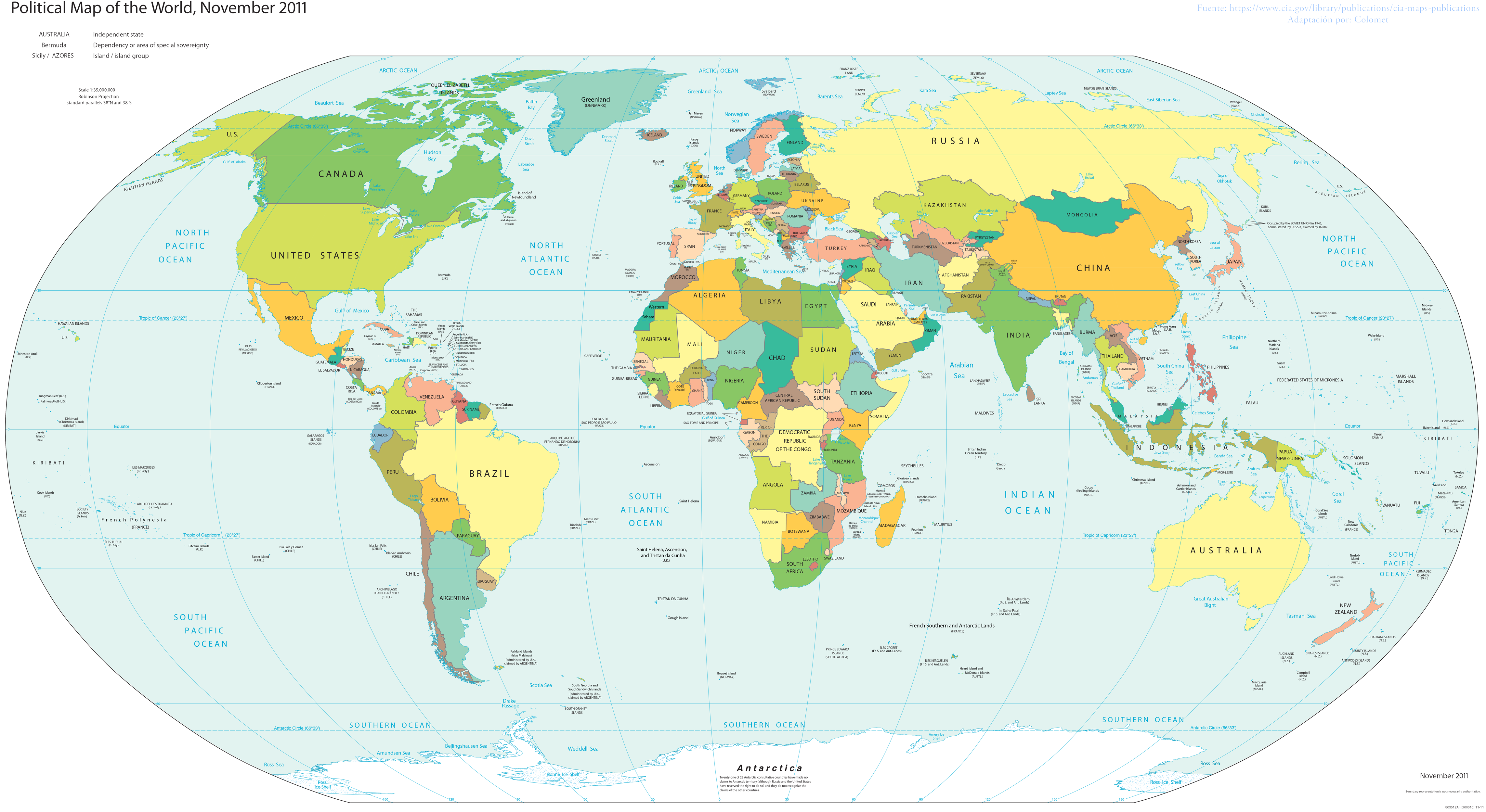
English: World map; partially inaccurate, as Taiwan is shown as part of China. POV-pushing users have reverted attempts to update this map to include other partially-unrecognized countries, due to the 2011 date on the map; however, South Sudan did not exist in 2011, and it's still on the map.
Reverted to version as of 23:35, 16 November 2017 (UTC) Crimea wasn't controlled by Russia in November 2011. Please fix the date. Also dont add Turkish occupation zones as Turkey, they are not.
Added back in Russian control over Ukraine as well as Turkish control of northern Syria, neither of which had been established when the map was created. Also added back in Abkhazia.
ไฟล, political, world, november, 2011, ไฟล, ประว, ไฟล, หน, าท, ภาพน, การใช, ไฟล, วนกลาง, อม, ลเก, ยวก, บภาพขนาดของต, วอย, างน, กเซล, ความละเอ, ยดอ, กเซล, กเซล, กเซล, กเซล, กเซล, กเซล, ภาพท, ความละเอ, ยดส, งกว, 8206, กเซล, ขนาดไฟล, เมกะไบต, ชน, ดไมม, image, ปภา. ifl prawtiifl hnathimiphaphni karichiflswnklang khxmulekiywkbphaphkhnadkhxngtwxyangni 800 437 phikesl khwamlaexiydxun 320 175 phikesl 640 350 phikesl 1 024 560 phikesl 1 280 700 phikesl 2 560 1 400 phikesl 4 572 2 500 phikesl duphaphthimikhwamlaexiydsungkwa 8206 4 572 2 500 phikesl khnadifl 3 46 emkaibt chnidimm image png rupphaphhruxiflesiyngni tnchbbxyuthi khxmmxns raylaexiyddanlang epnkhxkhwamthiaesdngphlcak ifltnchbbinkhxmmxns khxmmxnsepnewbistinokhrngkarsahrbekbrwbrwmsuxesri thi khunsamarthchwyid khwamyx This file requires updating because s CZECH REP CZECHIA s SWAZILAND eSWATINI label TAIWAN separately from CHINA In doing so you could add a timestamp to the file Please notify the uploader with code subst update note 1 File Political map of the World November 2011 png 2 s CZECH REP CZECHIA s SWAZILAND eSWATINI label TAIWAN separately from CHINA code khaxthibayPolitical map of the World November 2011 png English World map partially inaccurate as Taiwan is shown as part of China POV pushing users have reverted attempts to update this map to include other partially unrecognized countries due to the 2011 date on the map however South Sudan did not exist in 2011 and it s still on the map wnthi 31 mkrakhm ph s 2555 aehlngthima Basado en el Mapa politico de la CIA phusrangsrrkh Colomet ewxrchnxun karxnuyatichsiththi khapheca inthanaphuthuxlikhsiththikhxngphaphhruxsuxni xnuyatihichphaphhruxsuxniphayitenguxnikhtxipni iflnixyuphayitsyyaxnuyat khriexthifkhxmmxns aebbaesdngthima xnuyataebbediywkn 3 0 tnchbbkhunsamarth thicaaebngpn thicathasaena aeckcay aelasngngandngklawtxip thicaeriyberiyngihm thicaddaeplngngandngklaw phayitenguxnikhtxipni aesdngthima khuntxngihekiyrtiecakhxngnganxyangehmaasm odyephimlingkipyngsyyaxnuyat aelarabuhakmikarepliynaeplng khunxacthaechnniidinrupaebbidkidtamkhwr aettxngimichinlksnathiaenawaphuihxnuyatsnbsnunkhunhruxkarichngankhxngkhun xnuyataebbediywkn hakkhunddaeplng epliynrup hruxtxetimnganni khuntxngichsyyaxnuyataebbediywknhruxaebbthiehmuxnkbsyyaxnuyatthiichkbnganniethannhttps creativecommons org licenses by sa 3 0 CC BY SA 3 0 Creative Commons Attribution Share Alike 3 0 true true Public domain Public domain false false This image is in the public domain because it contains materials that originally came from the United States Central Intelligence Agency s World Factbook Bahasa Indonesia nbsp cestina nbsp Deutsch nbsp eesti nbsp English nbsp espanol nbsp Esperanto nbsp francais nbsp galego nbsp hrvatski nbsp italiano nbsp Nederlands nbsp norsk nynorsk nbsp polski nbsp portugues nbsp sicilianu nbsp slovenscina nbsp suomi nbsp Turkce nbsp Zazaki nbsp belaruskaya tarashkevica nbsp makedonski nbsp russkij nbsp srpski srpski nbsp ukrayinska nbsp ქართული nbsp ব ল nbsp தம ழ nbsp മലയ ള nbsp 한국어 nbsp 日本語 nbsp 中文 nbsp 中文 简体 nbsp 中文 繁體 nbsp العربية nbsp khabrryayodyyxithyephimkhabrryaythrrthdediywephuxkhyaykhwamwaiflnimixairixethmthiaesdngxyuiniflniprakxbdwyphusrangbangkhathiimmiixethmwikisnethschuxphusrangsrrkh Colometyuxaraexl https commons wikimedia org wiki user Colometchuxphuichwikimiediy ColometsthanalikhsiththimilikhsiththisyyaxnuyatCreative Commons Attribution ShareAlike 3 0 Unported nbsp xngkvswnthisrang wnkxtng31 mkrakhm 2012 prawtiifl khlikwnthi ewlaephuxduiflthipraktinkhnann lasud ekasud du ihmkwa 10 ekakwa 10 10 20 50 100 250 500 wnthi ewlarupyxkhnadphuichkhwamehn pccubn01 00 25 phvscikayn 25604 572 2 500 3 46 emkaibt Rob984Reverted to version as of 23 35 16 November 2017 UTC Crimea wasn 039 t controlled by Russia in November 2011 Please fix the date Also dont add Turkish occupation zones as Turkey they are not 02 17 24 phvscikayn 25604 572 2 500 3 43 emkaibt Koxem918Slight coloring fix in Russian area around Abkhazia 02 13 24 phvscikayn 25604 572 2 500 3 43 emkaibt Koxem918Added back in Russian control over Ukraine as well as Turkish control of northern Syria neither of which had been established when the map was created Also added back in Abkhazia 06 35 17 phvscikayn 25604 572 2 500 3 46 emkaibt MitolithReverted to version as of 23 13 31 January 2012 UTC 09 37 30 krkdakhm 25604 572 2 500 2 79 emkaibt Salem leo 1Added in Donetsk 039 s People 039 s Republic South Ossetia Abkhazia 04 03 27 minakhm 25604 572 2 500 3 43 emkaibt Salem LeoAdded in Kosovo 02 58 27 minakhm 25604 572 2 500 3 43 emkaibt Salem LeoAdded in area controlled by Turkey in Northern Syria due to Operation Euphrates Shield 01 45 27 minakhm 25604 572 2 500 3 41 emkaibt Salem LeoColouring fix 04 04 9 mkrakhm 25604 572 2 500 3 43 emkaibt Rob984Reverted to version as of 03 16 30 November 2016 UTC ISIS is not a recognised country 04 02 9 mkrakhm 25604 572 2 500 3 43 emkaibt Rob984Reverted to version as of 04 11 30 November 2016 UTC lasud ekasud du ihmkwa 10 ekakwa 10 10 20 50 100 250 500 hnathimiphaphni hnatxipni oyngmathiphaphni praeths karichiflswnklang wikixuntxipniichiflni karichbn ar wikipedia org بلد karichbn awa wikipedia org प र द श क भ ग ल karichbn crh wikipedia org Cografiya karichbn cv wikipedia org Geografi karichbn en wikipedia org User AndrewPeterT karichbn eo wikipedia org Lando karichbn es wikipedia org Usuario AndrewPeterT karichbn fa wikiquote org کشور karichbn fi wikipedia org Maailmankartta karichbn gl wikipedia org Pais karichbn ha wikipedia org Ƙasa yanki karichbn he wikipedia org ארץ גאוגרפיה karichbn ht wikipedia org Peyi karichbn incubator wikimedia org Wp ckt Nutenut karichbn ka wikipedia org პოლიტიკური გეოგრაფია karichbn lo wikipedia org ປະເທດ karichbn nl wikipedia org Staat politiek karichbn pt wikipedia org Predefinicao Projetos Paises Convite karichbn ru wikipedia org Politicheskaya geografiya karichbn sco wikipedia org Kintra karichbn si wikipedia org රට karichbn sv wikipedia org Land karichbn tly wikipedia org Numune Portal cografiye hafte secinye nivistey Numune Portal cografiye vijnie meqale3 Kisver Portal Cografiye vijnie meqale Arxiv Portal cografiye hafte secinye nivistey Arxiv Vyznije meǧole Arxiv karichbn uk wikipedia org Geografiya Krayina Krayinoznavstvo Politichna geografiya karichbn za wikipedia org Guekgyakhxmulekiywkbphaph phaphnimikhxmulephimetim sungswnihymacakklxngdicitxlhruxsaeknenxrthisamarthekbkhxmuldngklawiwrwmkbphaphid thaphaphnithukprbprungaekikhhruxepliynaeplngcakedim khxmulbangxyangcayngkhngimepliynaeplngehmuxnphaphthithukprbprungaekikhnnkhwamlaexiydaenwnxn118 11 dpckhwamlaexiydaenwtng118 11 dpc ekhathungcak https th wikipedia org wiki ifl Political map of the World November 2011 png, wikipedia, วิกิ หนังสือ, หนังสือ, ห้องสมุด,