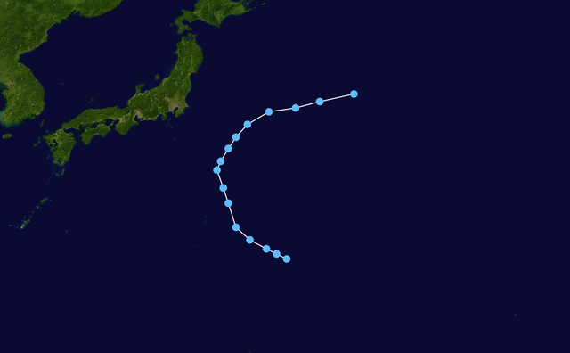
English: Track map of Tropical Depression 14W of the 2000 Pacific typhoon season. The points show the location of the storm at 6-hour intervals. The colour represents the storm's maximum sustained wind speeds as classified in the Saffir–Simpson scale (see below), and the shape of the data points represent the nature of the storm, according to the legend below.
Created by Nilfanion using WikiProject Tropical cyclones/Tracks. The background image is from NASA. Tracking data is from the Joint Typhoon Warning Center[1].
ไฟล, 2000, track, ไฟล, ประว, ไฟล, หน, าท, ภาพน, การใช, ไฟล, วนกลางขนาดของต, วอย, างน, กเซล, ความละเอ, ยดอ, กเซล, กเซล, กเซล, กเซล, กเซล, ภาพท, ความละเอ, ยดส, งกว, 8206, กเซล, ขนาดไฟล, โลไบต, ชน, ดไมม, image, ปภาพหร, อไฟล, เส, ยงน, นฉบ, บอย, คอมมอนส, รายละเอ, ย. ifl prawtiifl hnathimiphaphni karichiflswnklangkhnadkhxngtwxyangni 800 495 phikesl khwamlaexiydxun 320 198 phikesl 640 396 phikesl 1 024 633 phikesl 1 280 791 phikesl 2 700 1 669 phikesl duphaphthimikhwamlaexiydsungkwa 8206 2 700 1 669 phikesl khnadifl 682 kiolibt chnidimm image png rupphaphhruxiflesiyngni tnchbbxyuthi khxmmxns raylaexiyddanlang epnkhxkhwamthiaesdngphlcak ifltnchbbinkhxmmxns khxmmxnsepnewbistinokhrngkarsahrbekbrwbrwmsuxesri thi khunsamarthchwyid khwamyx khaxthibay14 W 2000 track png English Track map of Tropical Depression 14W of the 2000 Pacific typhoon season The points show the location of the storm at 6 hour intervals The colour represents the storm s maximum sustained wind speeds as classified in the Saffir Simpson scale see below and the shape of the data points represent the nature of the storm according to the legend below Saffir Simpson scale Tropical depression 38 mph 62 km h Tropical storm 39 73 mph 63 118 km h Category 1 74 95 mph 119 153 km h Category 2 96 110 mph 154 177 km h Category 3 111 129 mph 178 208 km h Category 4 130 156 mph 209 251 km h Category 5 157 mph 252 km h Unknown Storm type Tropical cyclone Subtropical cyclone Extratropical cyclone Remnant low Tropical disturbance Monsoon depressionwnthi 2000 08 06 2000 08 10aehlngthima Created by Nilfanion using WikiProject Tropical cyclones Tracks The background image is from NASA Tracking data is from the Joint Typhoon Warning Center 1 phusrangsrrkh Nilfanion karxnuyatichsiththi Public domain Public domain false falsenganniidthukephyaephrsusatharnsmbtiodyecakhxng Nilfanion sungmiphlthwolkinbangpraeths karkrathadngklawxacimsamarththaidtamkdhmayNilfanion xnuyatihthukkhnmisiththiinkarichiflniinthukehtuphlkarich odyimmimienguxnikh ewnaetkdhmayimxnuyatihthaechnnnkhabrryayodyyxithyephimkhabrryaythrrthdediywephuxkhyaykhwamwaiflnimixairixethmthiaesdngxyuiniflniprakxbdwysthanalikhsiththicopyrighted dedicated to the public domain by copyright holder xngkvssyyaxnuyatreleased into the public domain by the copyright holder xngkvsMIME type xngkvsimage png prawtiifl khlikwnthi ewlaephuxduiflthipraktinkhnann wnthi ewlarupyxkhnadphuichkhwamehn pccubn12 31 7 kumphaphnth 25652 700 1 669 682 kiolibt SupportstormJTWC BT data 13 20 23 kumphaphnth 25632 700 1 669 482 kiolibt Nino MarakotCorrections 06 01 11 thnwakhm 25572 700 1 669 681 kiolibt SupportstormCorrected points 08 38 7 mkrakhm 25501 024 633 124 kiolibt NilfaBot Information Description hurricane auto track map type Tropical Depression name subst PAGENAME source JTWC Source Date Author Permission other versions hnathimiphaphni hnatxipni oyngmathiphaphni vduphayuitfunaepsifik ph s 2543 karichiflswnklang wikixuntxipniichiflni karichbn en wikipedia org 2000 Pacific typhoon season User Tfmbty 2000 Pacific typhoon season karichbn vi wikipedia org Mua bao Tay Bắc Thai Binh Dương 2000 karichbn zh wikipedia org 2000年太平洋颱風季 ekhathungcak https th wikipedia org wiki ifl 14 W 2000 track png, wikipedia, วิกิ หนังสือ, หนังสือ, ห้องสมุด,